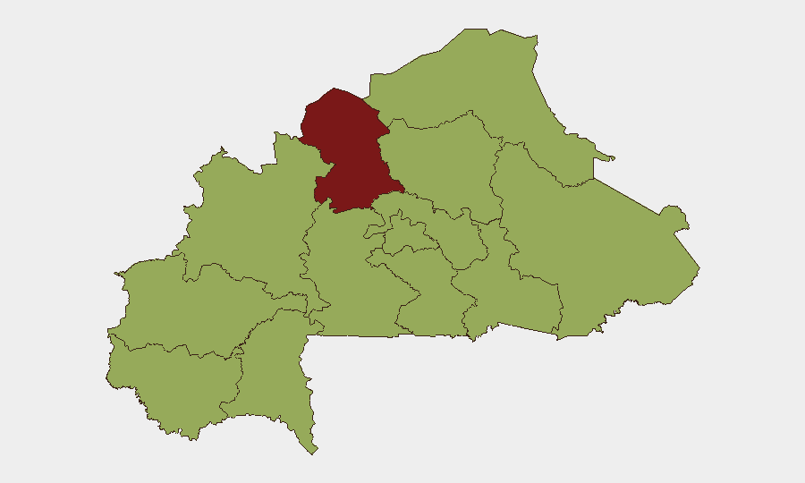
Situation Summary
Burkina Faso remains at elevated risk (global rank #20, composite score 72) driven primarily by active insurgency across multiple regions. The security environment is characterized by fragmented militant activity, periodic civil-military tensions, and limited state capacity in peripheral zones. Recent diplomatic friction and internal institutional strain signal potential secondary instability vectors beyond direct conflict.
Key Developments
Diplomatic Tension (22 June 2026). Ghana and a Major General representing Burkina Faso's military issued public statements on 22 June, indicating cross-border or bilateral friction. Nature and specific location unconfirmed from available sources; requires verification against regional diplomatic channels and official statements.
Institutional Incident (20 June 2026). Physical altercation between hospital and prosecutor personnel reported on 20 June. Specific location within Burkina Faso not yet confirmed; incident suggests potential breakdown in civil-institutional coordination during security operations or casualty management.
Note on Intelligence Gap: No additional discrete, location-specific, multi-source-verified incidents from 21–22 June 2026 could be confirmed within available research. Operational teams should cross-reference live feeds (AFP, Reuters, RFI Afrique, ACLED, regional embassies) for real-time updates on armed group activity, checkpoints, or clashes in priority zones.
Highest-Risk Areas
North Region dominates risk architecture (score 80), reflecting sustained militant presence, asymmetric attack capability, and limited government control. Ouagadougou area (Centre region, score 55.7) faces secondary risk driven by spillover political and institutional tensions, as reflected in recent civil-military friction.
Remaining regions (Sahel, East, Upper-Basins, Central zones) all score 50+, indicating geographically dispersed threat across the country. Risk is not confined to the traditional Sahel-North corridor; militant networks and banditry span multiple administrative zones, requiring country-wide vigilance rather than regional concentration.
How GeoBit Would Assist
Area-of-Interest (AOI) Monitoring & Early Warning with persistent, geofenced alerts on North, Centre, and Sahel regions would provide advance notice of militant activity, checkpoints, or security force movements affecting personnel or supply routes. Multi-language OSINT & Social Monitoring (French, local languages, X/Twitter, Telegram, radio SIGINT) would capture real-time military communiqués, militant claims, and civil unrest signals 4–24 hours ahead of mainstream media. Conflict & Military Intelligence (battle mapping, force structure tracking) combined with Routing & Network Analysis would enable security teams to identify safe transit corridors and preempt exposure to active clash zones.
7-Day Outlook
Near-term trajectory remains volatile. Diplomatic friction between Ghana and Burkina Faso may create secondary instability (border tensions, resource disputes) that compounds internal security fragmentation. Militant activity is expected to persist in North and peripheral regions; no significant de-escalation indicators are evident. Corporate teams should maintain heightened posture on personnel movements, emergency protocols, and communication redundancy through 29 June pending clarification of diplomatic developments and any resulting military repositioning.
Highest-Risk Areas — Ranked
| # | State / Region | Risk |
|---|---|---|
| 1 | North | 80 |
| 2 | Centre | 55.7 |
| 3 | Upper-Basins | 50 |
| 4 | Boucle du Mouhoun | 50 |
| 5 | Central-West | 50 |
| 6 | Central-South | 50 |
| 7 | Central-East | 50 |
| 8 | Waterfalls | 50 |
| 9 | Southwest | 50 |
| 10 | Sahel | 50 |
| 11 | Central-North | 50 |
| 12 | East | 50 |
Sources
Previous Daily Briefs
A new Burkina Faso brief is written every day — each with its own risk map and downloadable CSV. Here's the last week; use the calendar to go further back.
📅 Browse every day by calendar →
Highlighted days have a brief. Tap a day for that day's map & analysis, or “csv” for that day's dataset ($5).