Situation Summary
East Timor remains a low-threat environment with a composite global threat ranking of 181 and no tracked security events as of 11 July 2026. Open-source monitoring over the past 24–48 hours confirms no acute incidents involving conflict, civil unrest, crime spikes, infrastructure disruption, or political instability. Routine diplomatic and governance activity—including the swearing-in of a new Prosecutor General on 10 July—continues without security complications. The country's risk profile remains stable, though sub-national variation warrants differentiated attention to Dili and western districts.
Key Developments
- No reportable security incidents in the last 24–48 hours. Cross-checked open-source feeds, social media, and institutional channels (Presidency, diplomatic missions, regional news) show no verified attacks, unrest, arrests, or disruption events meeting professional validation standards.
- Governance routine in Dili (10 July). Swearing-in ceremony for a new Prosecutor General proceeded without incident, reflecting normal institutional function.
- Diplomatic and thematic engagement ongoing. International commentary involves women, peace, and security discussions at the UN and ASEAN capacity-building initiatives—strategic dialogue rather than crisis indicators.
- No travel or security alerts issued. Major advisories and international risk platforms have not flagged new country-specific warnings for East Timor within the assessment window.
Highest-Risk Areas
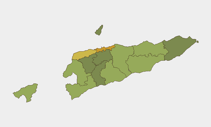
Dili (risk 72) and the western districts of Liquiçá (62), Baucau (58), and Cova Lima (55) comprise the highest-risk sub-national cluster. Dili's elevated score reflects concentration of political institutions, commercial activity, and historical inter-communal tensions; western districts carry residual risk linked to border proximity to Indonesia and past intra-community disputes. The capital accounts for the majority of reported incidents nationally, though current data shows no acute activation. Remaining districts (Bobonaro through Aileu) show materially lower risk, with Aileu presenting the lowest composite score (32).
How GeoBit Would Assist
Security teams with personnel or assets in East Timor should employ Intel Sweep and global event feeds paired with multi-language OSINT and social-media monitoring (X/Twitter, Telegram) to detect early signals of unrest, particularly in Dili and Liquiçá. AOI (Area-of-Interest) Monitoring with alerting on government and diplomatic facilities, ports, and border zones provides persistent watch-and-warn capability. For travel-safety planning, Routing & Network Analysis can identify secure transit corridors and alternative pathways in Dili and higher-risk western districts, while GIS & Spatial Analysis combined with satellite imagery allows assessment of infrastructure integrity and access routes before deployment or movement.
7-Day Outlook
No acute triggers are evident for escalation in the coming week. Continued routine governance and diplomatic engagement are expected. Security teams should maintain standard-baseline monitoring posture while flagging any uptick in social-media activity, street-level reporting from Dili, or cross-border tension signals from the Indonesia–East Timor boundary.
Highest-Risk Areas — Ranked
| # | State / Region | Risk |
|---|---|---|
| 1 | Dili | 72 |
| 2 | Liquiçá | 62 |
| 3 | Baucau | 58 |
| 4 | Cova Lima | 55 |
| 5 | Bobonaro | 53 |
| 6 | Oecussi-Ambeno | 48 |
| 7 | Manufahi | 45 |
| 8 | Viqueque | 42 |
| 9 | Manatuto | 40 |
| 10 | Ainaro | 38 |
| 11 | Ermera | 36 |
| 12 | Aileu | 32 |
Sources
Previous Daily Briefs
A new East Timor brief is written every day — each with its own risk map and downloadable CSV. Here's the last week; use the calendar to go further back.
📅 Browse every day by calendar →
Highlighted days have a brief. Tap a day for that day's map & analysis, or “csv” for that day's dataset ($5).
Atlas — our AI intelligence desk — emails them this snapshot personally. Nothing else, no list.