Situation Summary
Estonia remains a low-threat country overall (composite threat score 1), but faces elevated risk in border and migration-adjacent zones due to regional instability. The most significant near-term stressors are cross-border migration flows from Belarus/Latvia and periodic aerial incursions in the broader Baltic-NATO airspace. No major security incidents have been confirmed in the past 24–48 hours, though localized hazards (flooding) and ongoing border-management operations continue.
Key Developments
- Tõrva, Valga County (2026-07-29): Authorities evacuated 10 people following flooding; Valga County ranks fifth nationally in composite risk (55), partly reflecting exposure to environmental and border pressures.
- Tallinn migrant detention (past 3 days, reported 2026-07-29): Police detained 32 foreign nationals—most lacking identity documents, some claiming asylum—linked to Belarus/Latvia migration routes. Detainees were held at Nõmme reception center and port facilities.
- Estonia–Latvia border reinforcement (2026-07-29): Estonia announced deployment of additional Border Guard personnel to Latvia in response to recent migrant detentions, signaling sustained concern over Belarus-routed irregular migration.
- Baltic airspace precautions (2026-07-28): Regional drone incursions prompted NATO-aligned precautionary airspace restrictions across the Baltic-Finnish zone; Estonia is part of the affected frontier but no Estonia-specific new incident was independently confirmed in the reporting window.
- Russian diplomatic allegations (2026-07-25): Russia's representative in Tallinn alleged Estonia was concealing information about Ukrainian drone activity in Estonian airspace; claim remains unverified and represents diplomatic posturing rather than confirmed incident.
Highest-Risk Areas
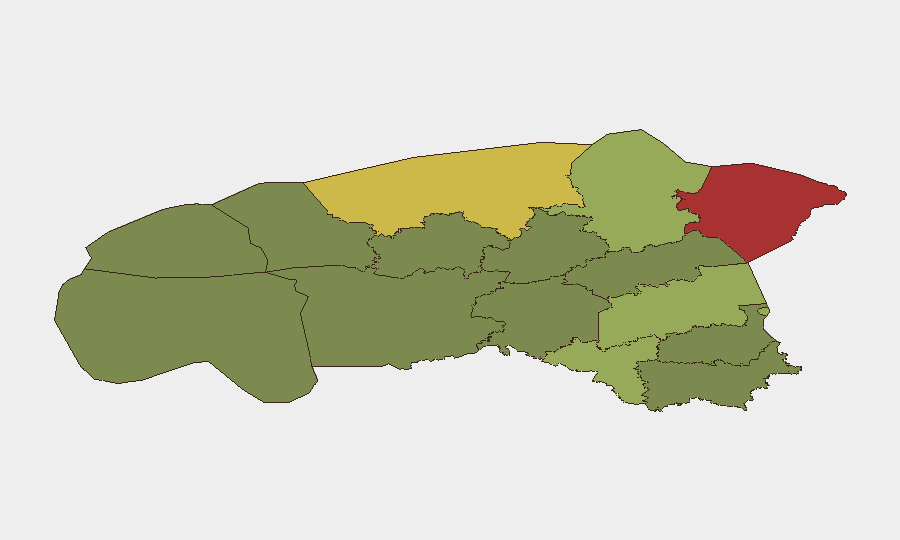
Ida-Viru County (78) and Harju County (68) dominate the national risk profile. Ida-Viru's elevated score reflects proximity to Russian territory, historical aerial incidents (e.g., March drone strike on Auvere power station), and energy-infrastructure exposure. Harju County, containing Tallinn and the capital's port and international border checkpoints, faces compounded risk from migration flows, maritime transit, and density of critical infrastructure and foreign nationals. Tartu County (58) and Valga County (55)—the latter now marked by recent flooding—round out the top tier, with Valga's risk driven partly by its position on the Belarus/Latvia migration corridor and exposure to cross-border instability. Lower-ranked counties (Põlva, Võru) show substantially reduced composite scores and are suitable for lower-vigilance posturing.
How GeoBit Would Assist
Security teams operating in Estonia should employ AOI (Area of Interest) Monitoring & Early Warning on Ida-Viru and Harju counties to detect aerial, maritime, or border-crossing anomalies in near-real time. Intel Sweep and multi-language OSINT (including Estonian and Russian sources) would provide early signals of diplomatic escalation, migration surge, or airspace violations. GIS & Spatial Analysis and alternative route planning help corporate teams optimize personnel movement and facility security in high-risk zones (Tallinn port, Tapa, energy installations).
7-Day Outlook
No imminent large-scale security event is indicated. Migration pressure and diplomatic friction along the Belarus–Estonia–Latvia frontier will likely persist, with Estonia sustaining elevated border vigilance. Aerial incursion risk remains ambient in the broader NATO-Russia context but has not materialized into confirmed Estonian territory incidents in recent weeks. Environmental hazards (flooding, seasonal weather) warrant continued monitoring in rural/coastal zones.
Highest-Risk Areas — Ranked
| # | State / Region | Risk |
|---|---|---|
| 1 | Ida-Viru County | 78 |
| 2 | Harju County | 68 |
| 3 | Tartu County | 58 |
| 4 | Valga County | 55 |
| 5 | Lääne-Viru County | 52 |
| 6 | Pärnu County | 35 |
| 7 | Rapla County | 32 |
| 8 | Jõgeva County | 30 |
| 9 | Järva County | 28 |
| 10 | Viljandi County | 25 |
| 11 | Põlva County | 22 |
| 12 | Võru County | 18 |
Sources
Previous Daily Briefs
A new Estonia brief is written every day — each with its own risk map and downloadable CSV. Here's the last week; use the calendar to go further back.
📅 Browse every day by calendar →
Highlighted days have a brief. Tap a day for that day's map & analysis, or “csv” for that day's dataset ($5).
Atlas — our AI intelligence desk — emails them this snapshot personally. Nothing else, no list.