Situation Summary
Grenada remains at low overall security risk (global rank #167, composite score 5) with no verified security incidents reported in the last 24–48 hours across available news sources. Sub-national risk concentration in Saint George (92) and Saint Andrew (78) reflects endemic urban crime patterns typical of the Eastern Caribbean, but no acute destabilizing events are evident. The security environment is stable with no signals of imminent civil unrest, infrastructure disruption, or cross-border spillover from neighboring jurisdictions.
Key Developments
No verified security, crime, civil-unrest, political-instability, or infrastructure incidents were reported in Grenada during 23–24 August 2026 in available public sources. Web research covering local media (Grenada Broadcasting Network, Now Grenada, The New Today) and regional reporting produced no corroborated events meeting the 24–48-hour window. A Cuban national reported missing on 19 August 2026 was subsequently located safe in hospital; this falls outside the current reporting period. Recent incidents identified in search results were geographically misattributed to Saint Vincent and the Grenadines (a separate nation), not Grenada. Absence of reported incidents does not preclude security activity; limitations in real-time source access and local reporting lag mean minor incidents may not yet surface in indexed media.
Highest-Risk Areas
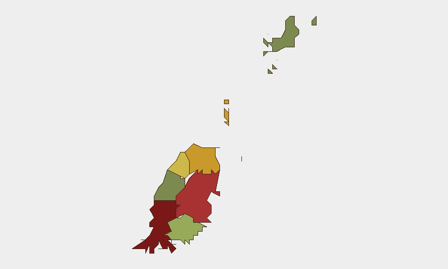
Saint George (composite risk 92) and Saint Andrew (78) account for the majority of documented sub-national threat concentration, consistent with urban gang activity, narcotics trafficking, and property crime endemic to the capital and northern residential zones. Saint Patrick (71) and Saint Mark (64) show elevated secondary risk, likely linked to transport corridors and informal settlement areas. Carriacou and Petite Martinique (12) register minimal risk, reflecting lower population density and institutional capacity. Risk drivers in the top-ranked parishes reflect persistent Caribbean patterns of organized crime and urban violence rather than political instability or state failure; duty-of-care teams should prioritize movement protocols and asset placement in lower-ranked rural and island districts.
How GeoBit Would Assist
Intel Sweep and multi-language search capabilities, combined with OSINT fusion & corroboration, enable continuous monitoring of local news, social media (X, Telegram), and Grenada Broadcasting Network for early signals of crime clusters, gang activity, or infrastructure disruption. AOI Monitoring & Early Warning with persistent geographic alerting on Saint George and Saint Andrew would flag emerging incidents within hours of local reporting, allowing security teams to adapt travel routing and asset protection in real time. Network & Actor Analysis linked to regional maritime and narcotics-trafficking data provides context on criminal networks transiting the Grenadine islands, supporting risk stratification for personnel and supply chains.
7-Day Outlook
No acute escalation drivers are evident; Grenada's security trajectory remains stable barring external shocks (e.g., significant narcotics seizures triggering gang retaliation, regional conflict spillover). Seasonal hurricane season (through November) presents infrastructure vulnerability; monitoring of weather alerts and port/airport operational status is recommended. Continued reliance on real-time local reporting and official government advisories is essential for detection of emerging incidents that may not immediately surface in English-language news aggregators.
Highest-Risk Areas — Ranked
| # | State / Region | Risk |
|---|---|---|
| 1 | Saint George | 92 |
| 2 | Saint Andrew | 78 |
| 3 | Saint Patrick | 71 |
| 4 | Saint Mark | 64 |
| 5 | Saint David | 52 |
| 6 | Saint John | 38 |
| 7 | Carriacou and Petite Martinique | 12 |
Sources
Previous Daily Briefs
A new Grenada brief is written every day — each with its own risk map and downloadable CSV. Here's the last week; use the calendar to go further back.
- August 22, 2026
- August 20, 2026
- August 18, 2026
- August 16, 2026
- August 14, 2026
- August 12, 2026
- August 10, 2026
📅 Browse every day by calendar →
Highlighted days have a brief. Tap a day for that day's map & analysis, or “csv” for that day's dataset ($5).
Atlas — our AI intelligence desk — emails them this snapshot personally. Nothing else, no list.