Situation Summary
Guinea-Bissau remains at composite threat level #137 globally with no acute security incidents reported in the last 24–48 hours. However, the country faces elevated political risk stemming from opposition boycott calls ahead of a constitutional referendum scheduled for 30 August 2026, combined with a newly confirmed mpox outbreak affecting an estimated 46 suspected cases. The security environment is shaped more by political friction and public-health concern than by active violence or infrastructure collapse at present, though the referendum vote carries material risk of domestic unrest.
Key Developments
- 24 Aug 2026 · Public Health · Countrywide – Guinea-Bissau authorities and WHO confirm ongoing mpox outbreak with approximately 46 suspected cases, including seven laboratory-confirmed adult cases and roughly half affecting children; no deaths reported to date. This marks the country's first recorded mpox outbreak and introduces health-related travel and operational risk.
- 23 Aug 2026 · Political Protest · Lisbon, Portugal – Guinea-Bissau diaspora members demonstrated in central Lisbon against the upcoming constitutional referendum, characterizing it as "golpista" (coup-linked) and criticizing the military-backed authorities in power since November 2025. While outside Guinea-Bissau, this signals heightened political mobilization with potential to translate into domestic demonstrations closer to the 30 August vote.
- 21–24 Aug 2026 · Political Crisis · Countrywide (ongoing) – Opposition parties, including PAIGC, maintain public calls for boycott of the 30 August constitutional referendum, citing exclusionary process and criticism of expanded presidential powers. Boycott messaging and political tension remain active and referenced across multiple sources through 24 August.
- 18 Aug 2026 · Trade Dispute · Cross-border (Senegal–Guinea-Bissau) – Senegalese transport operators suspended journeys to Guinea-Bissau following an unresolved dispute with Bissau-Guinean counterparts, affecting regional logistics and cross-border movement. Status of dispute resolution remains unclear.
Highest-Risk Areas
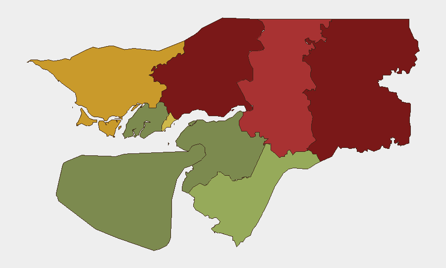
Gabu Region (risk 92) and Oio Region (risk 85) present the sharpest sub-national threat profile, likely driven by proximity to Senegal, historical armed-group activity, and porous borders. Bafatá (risk 78) and Cacheu (risk 72) regions follow, while Bissau Autonomous Sector (risk 68)—the capital and administrative hub—carries significant risk tied to political institutions, security-force concentration, and protest flashpoints. Southern and eastern regions show materially lower risk, with Bolama Region (risk 15) representing the least acute threat zone.
How GeoBit Would Assist
Security teams should deploy AOI (Area-of-Interest) Monitoring & Early Warning focused on Bissau and Gabu Region to detect protest mobilization, security-force activity, and civil unrest around the 30 August referendum. OSINT Fusion & Corroboration (X/Twitter, Telegram, local media feeds, multi-language search) will track opposition messaging, diaspora coordination, and on-ground sentiment shifts. Election Monitoring capabilities can provide real-time situational awareness of turnout, reported incidents, and post-vote stability, while Routing & Network Analysis supports contingency travel planning should road closures or border restrictions occur around key political dates.
7-Day Outlook
The 30 August referendum represents the near-term focal point for domestic risk escalation. Opposition boycott campaigns and diaspora mobilization suggest potential for organized demonstrations or civil disobedience around the vote, though no large-scale violence has been forecast or confirmed. mpox surveillance and cross-border trade friction will remain secondary but persistent operational concerns; monitoring should intensify through the referendum and into early September to assess post-vote stability and any spillover political friction ahead of December elections.
Highest-Risk Areas — Ranked
| # | State / Region | Risk |
|---|---|---|
| 1 | Gabu Region | 92 |
| 2 | Oio Region | 85 |
| 3 | Bafatá Region | 78 |
| 4 | Cacheu Region | 72 |
| 5 | Bissau Autonomous Sector | 68 |
| 6 | Tombali Region | 45 |
| 7 | Quinara Region | 38 |
| 8 | Biombo Region | 32 |
| 9 | Bolama Region | 15 |
Sources
Previous Daily Briefs
A new Guinea-Bissau brief is written every day — each with its own risk map and downloadable CSV. Here's the last week; use the calendar to go further back.
- August 22, 2026
- August 20, 2026
- August 17, 2026
- August 15, 2026
- August 13, 2026
- August 11, 2026
- August 10, 2026
📅 Browse every day by calendar →
Highlighted days have a brief. Tap a day for that day's map & analysis, or “csv” for that day's dataset ($5).
Atlas — our AI intelligence desk — emails them this snapshot personally. Nothing else, no list.