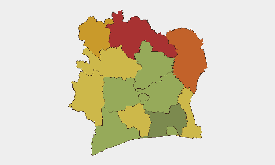
Situation Summary
Ivory Coast remains ranked #82 globally on GeoBit's threat index, with composite risk driven primarily by persistent insurgency and terrorism threats in its northern border zones rather than active domestic instability or unrest in major urban centers. No discrete security incidents have been recorded in the 24–48 hour window; the threat environment reflects chronic, rather than acute, escalation. The country's risk profile is heavily concentrated in the savanna and forested districts abutting Mali and Burkina Faso, where cross-border militant activity and arms trafficking create sustained vulnerability.
Key Developments
- No discrete events recorded in the past 24–48 hours. GeoBit's live research sweep identified no new incidents, attacks, civil unrest, infrastructure failures, or travel disruptions with verified timestamps within this window.
- Background context (4–5 Aug, Kossandji/Alépé area): Older reporting indicates localized violence in the southeast, but this falls outside the current 48-hour window and does not reflect an emerging trend.
- Persistent infrastructure strain (non-time-specific): Water supply disruptions affecting Yopougon's industrial zone have persisted for weeks, reflecting fragile utility resilience but not an acute crisis.
- Standing advisory: Northern border zones remain high-risk. Germany's Foreign Office and comparable travel agencies continue to warn against non-essential travel to the far northeast and immediate borders with Mali and Burkina Faso, citing terrorism and armed violence as persistent threats; this reflects stable (not new) risk classification.
Highest-Risk Areas
The top five districts—Savanes, Zanzan, Denguélé, Comoé, and Montagnes (composite risk scores 78–68)—collectively form Ivory Coast's northern and northeastern frontier. All border Mali and/or Burkina Faso, regions with active al-Qaeda and Islamic State affiliates, trafficking networks, and transnational militant operations. These zones experience sporadic but recurring armed clashes, abductions, and roadside attacks; civilian movement is significantly constrained. Mid-tier risk areas (Woroba, Gôh-Djiboua, Sassandra-Marahoué) extend the vulnerable band westward and southwestward along remote, sparsely governed corridors. By contrast, Abidjan, the commercial capital, registers substantially lower risk (45), reflecting tighter state security presence and urban infrastructure, though petty crime, gang activity, and opportunistic kidnapping remain baseline concerns for expatriate and corporate populations.
How GeoBit Would Assist
Security and risk teams operating in Ivory Coast should deploy AOI (Area-of-Interest) Monitoring & Early Warning on Savanes, Zanzan, and Denguélé districts to capture emerging militant activity, roadside incidents, and cross-border movement before they escalate. Intel Sweep and multi-language OSINT fusion (including X, Telegram, and local radio SIGINT) enable real-time detection of armed group announcements, recruitment, or attack claims that precede or accompany incidents. For personnel routing and supply-chain resilience, Routing & Network Analysis identifies alternative routes and safe transit corridors away from highest-risk zones, while Satellite & Imagery analysis provides persistent visual intelligence on military concentrations, checkpoints, and road conditions in remote areas.
7-Day Outlook
No escalation is forecast for the immediate week; risk remains chronic rather than cyclical. Monitoring should remain focused on the northern frontier for early signals of cross-border incursions, al-Qaeda or ISIS-affiliated activity, or new roadblocks. Abidjan and southern commercial zones are expected to remain relatively stable, though routine urban crime and civil-order incidents should continue to be factored into duty-of-care protocols.
Highest-Risk Areas — Ranked
| # | State / Region | Risk |
|---|---|---|
| 1 | Savanes District | 78 |
| 2 | Zanzan District | 75 |
| 3 | Denguélé District | 72 |
| 4 | Comoé District | 70 |
| 5 | Montagnes District | 68 |
| 6 | Woroba District | 65 |
| 7 | Gôh-Djiboua District | 60 |
| 8 | Sassandra-Marahoué District | 58 |
| 9 | Vallée du Bandama District | 55 |
| 10 | Bas-Sassandra District | 52 |
| 11 | Lacs District | 48 |
| 12 | Abidjan | 45 |
Sources
Previous Daily Briefs
A new Ivory Coast brief is written every day — each with its own risk map and downloadable CSV. Here's the last week; use the calendar to go further back.
📅 Browse every day by calendar →
Highlighted days have a brief. Tap a day for that day's map & analysis, or “csv” for that day's dataset ($5).
Atlas — our AI intelligence desk — emails them this snapshot personally. Nothing else, no list.