Situation Summary
Latvia maintains a stable security environment with no verified major incidents, civil unrest, or infrastructure disruption reported in the last 24–48 hours. The country's composite threat score of 5 (global rank #149) reflects a low-threat baseline, though sub-national risk concentration in the eastern border regions—particularly Rēzekne, Daugavpils, and adjacent municipalities—warrants focused monitoring. Two tracked event signals dated 2026-07-15 (aerial weapons activity and diplomatic disapproval) remain under assessment and do not currently indicate acute domestic security degradation. The operating environment for corporate personnel and assets remains within normal safety parameters.
Key Developments
Open-source monitoring and multi-language search across Latvia over the last 24–48 hours have not yielded documented, time-stamped security incidents meeting threshold criteria (armed conflict, terrorist activity, civil unrest, major crime events, infrastructure failure, or travel-risk escalation). The most recent structured security assessment (GeoBit Latvia Security Brief, 2026-07-13) confirmed no major incidents in the prior 24–48-hour window; no corroborated new reports have emerged since that publication date. Accordingly, no discrete incident bullets are presented. Organizations should note that the absence of reported events does not eliminate residual risks in high-risk eastern regions or the need for standard duty-of-care protocols.
Highest-Risk Areas
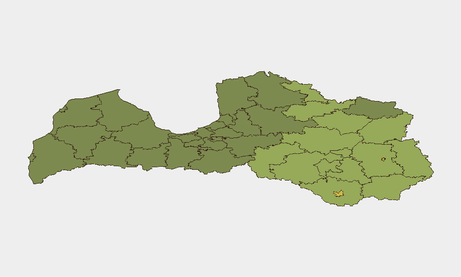
Eastern Latvia—spanning Rēzekne (risk 68), Daugavpils (65), and surrounding municipalities (Rēzeknes novads 58, Ludzas novads 55, Balvu novads 52)—concentrates the majority of the country's sub-national risk. These regions, located near the Russian and Belarus borders, have historically elevated exposure to cross-border tensions, smuggling activity, and dual-use trade concerns. Risk scores decline progressively westward; central and western municipalities (Aizkraukles, Varakļānu, Līvānu) register substantially lower composite scores. The risk gradient reflects geopolitical proximity rather than active current incidents, but corporate teams with operations or personnel in the east should maintain heightened situational awareness and liaison with local authorities.
How GeoBit Would Assist
Security teams managing Latvia exposure should employ AOI Monitoring & Early Warning on eastern border municipalities to detect emerging civil unrest, cross-border activity, or infrastructure disruption in real time. Intel Sweep (global event feeds, X/Telegram OSINT, multi-language search) provides continuous tracking of political statements, diplomatic incidents, and security-relevant developments affecting Latvia's NATO standing and border stability. For personnel routing and contingency planning, Routing & Network Analysis capabilities can model alternative transport corridors and safe zones in high-risk eastern regions, integrating current conflict and security data into journey-risk assessment.
7-Day Outlook
Latvia's near-term trajectory remains stable absent new external shocks or border escalation. Continued NATO presence and bilateral defense commitments maintain baseline deterrence in eastern regions. Corporate risk teams should sustain standard security protocols, monitor the two tracked event signals for resolution or escalation, and refresh internal travel guidance for eastern municipalities if conditions shift. No material change in threat level is currently forecast.
Highest-Risk Areas — Ranked
| # | State / Region | Risk |
|---|---|---|
| 1 | Rēzekne | 68 |
| 2 | Daugavpils | 65 |
| 3 | Rēzeknes novads | 58 |
| 4 | Ludzas novads | 55 |
| 5 | Balvu novads | 52 |
| 6 | Preiļu novads | 50 |
| 7 | Krāslavas novads | 48 |
| 8 | Jēkabpils novads | 47 |
| 9 | Augšdaugavas novads | 46 |
| 10 | Aizkraukles novads | 45 |
| 11 | Varakļānu novads | 44 |
| 12 | Līvānu novads | 43 |
Sources
Previous Daily Briefs
A new Latvia brief is written every day — each with its own risk map and downloadable CSV. Here's the last week; use the calendar to go further back.
📅 Browse every day by calendar →
Highlighted days have a brief. Tap a day for that day's map & analysis, or “csv” for that day's dataset ($5).
Atlas — our AI intelligence desk — emails them this snapshot personally. Nothing else, no list.