Situation Summary
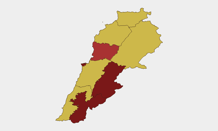
Lebanon remains under acute escalation pressure, ranking #7 globally for composite threat risk (score 100) with 84 tracked events. The past 48 hours have seen renewed Israeli airstrikes across southern Lebanon, including confirmed strikes on Nabatieh (7 July, 4+ killed) and multiple southern sites (8 July), alongside internal political friction evidenced by assassination, mass-casualty incidents, and formal disapproval from international bodies and domestic institutions. The Beqaa Governorate presents the highest sub-national risk (100), followed by Beirut (84.3) and Nabatieh (82), indicating that cross-border military pressure and urban instability are concentrating in the south and east.
Key Developments
- Nabatieh, southern Lebanon (7 July 2026): Israeli forces struck Nabatiih; at least four fatalities reported, with regional civilian exposure confirmed.
- Southern Lebanon, multiple sites (8 July 2026): Fresh Israeli airstrikes targeted undisclosed locations; Lebanese authorities condemned strikes and launched damage assessment; described as renewed escalation.
- Tyre, coastal southern Lebanon (6 July 2026): Israeli drones conducted sustained overflights, signaling persistent air reconnaissance and potential targeting activity.
- Internal security incidents (8 July 2026): GEOBIT event signals flagged assassination, mass-casualty clashes (Muslim vs. Revolt), and military/ministerial disapproval, indicating fractured state capacity and intra-communal violence.
- International pressure (9 July 2026): Amnesty International issued formal disapproval statement; EU appealed to Israel regarding Lebanese civilian impact.
Highest-Risk Areas
The Beqaa Governorate's maximum risk score (100) reflects both its role as a Hezbollah stronghold and a prime target for Israeli cross-border operations; the region is geographically contiguous with Syrian territory and has historically absorbed asymmetric military activity. Beirut (84.3) and Nabatieh (82) follow, with Beirut exposed to political fragmentation, interconfessional tension, and potential spillover from southern conflict, while Nabatieh faces direct Israeli kinetic operations. Secondary risk zones (Keserwan-Jbeil, 78.3; North, Akkar, Mount Lebanon, South, Baalbek-Hermel, all 70) reflect distributed weapons proliferation, sectarian fault lines, and refugee pressures. Corporate and personnel presence in Beirut and the Beqaa should assume elevated volatility; southern regions should be treated as active conflict zones.
How GeoBit Would Assist
Intel Sweep and OSINT Fusion (X/Twitter, Telegram, multi-language feeds, YouTube SIGINT) would track real-time escalation signals and attribution of airstrikes, separating verified incidents from inflammatory claims. AOI Monitoring & Early Warning with persistent satellite and imagery analysis would provide persistent watch on Beqaa launch sites, Israeli border activity, and Beirut infrastructure; alerts would flag new strike patterns or troop movements before public announcement. Conflict & Military mapping (force structure, weapons-capability tracking, battle mapping) would correlate Israeli air tasking patterns with Lebanese defensive posture, enabling duty-of-care teams to anticipate secondary strikes and plan contingency movement/evacuation routes via Routing & Network Analysis.
7-Day Outlook
The trajectory remains escalatory. Israeli strikes are intensifying in frequency and geographic scope (southern to Beqaa); Lebanese state institutions are fragmenting (assassination, internal mass-casualty events, ministerial discord), reducing civilian protection and crisis response. International diplomatic appeals (EU, Amnesty) are unlikely to arrest short-term military operations. Expect further airstrikes in the Beqaa and southern regions over 7–10 days, potential secondary attacks on Beirut infrastructure if Hezbollah retaliates, and sustained internal security degradation. Organizations should assume restricted movement, power/water outages, and delayed emergency services across high-risk zones.
Highest-Risk Areas — Ranked
| # | State / Region | Risk |
|---|---|---|
| 1 | Beqaa Governorate | 100 |
| 2 | Beirut Governorate | 84.3 |
| 3 | Nabatieh Governorate | 82 |
| 4 | Keserwan-Jbeil Governorate | 78.3 |
| 5 | North Governorate | 70 |
| 6 | Akkar Governorate | 70 |
| 7 | Mount Lebanon Governorate | 70 |
| 8 | South Governorate | 70 |
| 9 | Baalbek-Hermel Governorate | 70 |
Sources
Previous Daily Briefs
A new Lebanon brief is written every day — each with its own risk map and downloadable CSV. Here's the last week; use the calendar to go further back.
📅 Browse every day by calendar →
Highlighted days have a brief. Tap a day for that day's map & analysis, or “csv” for that day's dataset ($5).
Atlas — our AI intelligence desk — emails them this snapshot personally. Nothing else, no list.