Situation Summary
Lesotho remains a low-threat environment overall (global rank #150, composite score 6), with no documented security incidents, civil unrest, or armed conflict recorded in the last 24–48 hours. The primary near-term risk stems from severe weather disruption—snowfall and high winds affecting mountainous and border regions as of mid-August—which has degraded infrastructure, road access, and emergency-service capacity in affected areas. Indirect humanitarian stress in rural communities may elevate petty crime risk, though no organized criminal or political instability has materialized. The national threat posture remains stable.
Key Developments
• Maseru and mountain districts, Lesotho (August 12, ongoing): Severe snowfall and strong winds continue to disrupt cross-border travel, damage housing, and kill livestock in high-altitude zones. Road closures and infrastructure strain are expected to persist through mid-August, constraining emergency-service access and humanitarian logistics in affected rural communities.
• National cyber-security capacity improvement (July 29, reported early August): Lesotho's government launched a national Computer Security Incident Response Team (CSIRT), enhancing the country's ability to detect, report, and coordinate response to digital-security incidents. No incidents have been triggered, but institutional capability for future cyber-event handling has been strengthened.
• Regional context—Lesotho nationals in South African mining accident (August 10–11, outside Lesotho territory): A rock fall at an illegal chrome mine near Marikana, South Africa killed 14 miners, the majority Lesotho nationals. This reflects elevated personal-safety risk for Lesotho nationals engaged in high-risk informal-sector work abroad, but does not indicate instability within Lesotho itself.
Highest-Risk Areas
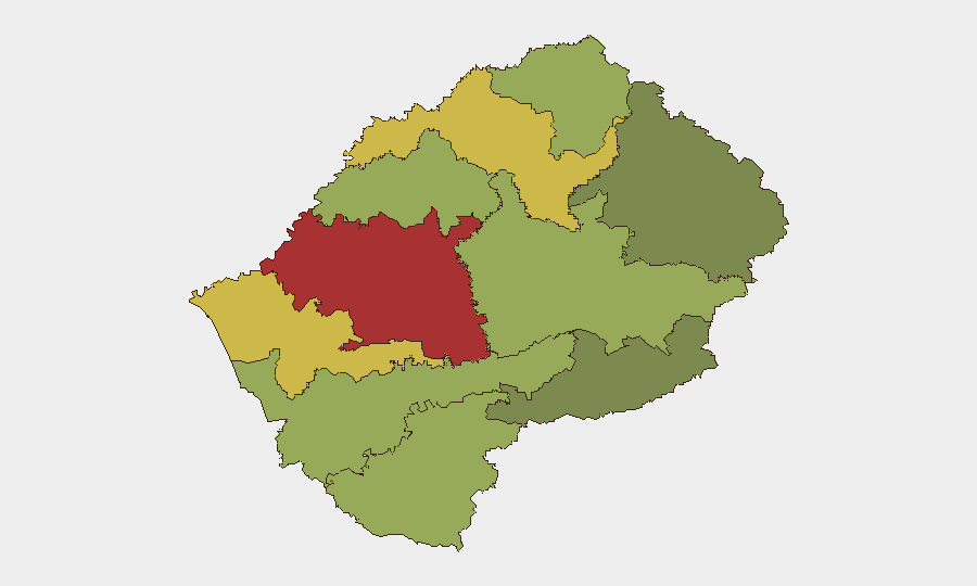
Maseru District (risk 78) and Mafeteng District (risk 65) drive the sub-national ranking, reflecting concentrated exposure to petty crime, economic stress, and now weather-related infrastructure vulnerability. Leribe and Berea districts (risks 62 and 58) face similar pressures. The mountain districts (Butha-Buthe, Thaba-Tseka, Mokhotlong) rank lower in absolute risk but are acutely exposed to current weather disruption and have limited emergency-service capacity. Urban Maseru concentrates population, administrative assets, and economic activity, whereas rural mountain zones face seasonal isolation and resource scarcity that weather events amplify.
How GeoBit Would Assist
A security team protecting people or assets in Lesotho would deploy AOI Monitoring & Early Warning on Maseru District and key border crossings to track weather-related closures and civil-order developments in real time. Intel Sweep and multi-language OSINT across Lesotho-focused news, social media, and regional feeds would provide early detection of protest activity, crime spikes, or political instability that could affect operations. Routing & Network Analysis would enable alternative-route planning for personnel and supply chains during infrastructure disruption, particularly in mountainous zones.
7-Day Outlook
Weather disruption is expected to ease by late August as seasonal patterns shift, gradually restoring road access and reducing infrastructure strain. No indicators suggest political upheaval, organized crime escalation, or cross-border conflict in the near term. Security teams should maintain heightened awareness of road conditions and humanitarian access constraints in rural districts until weather-impact reporting normalizes.
Highest-Risk Areas — Ranked
| # | State / Region | Risk |
|---|---|---|
| 1 | Maseru District | 78 |
| 2 | Mafeteng District | 65 |
| 3 | Leribe District | 62 |
| 4 | Berea District | 58 |
| 5 | Mohale's Hoek District | 52 |
| 6 | Butha-Buthe District | 48 |
| 7 | Thaba-Tseka District | 45 |
| 8 | Quthing District | 42 |
| 9 | Mokhotlong District | 38 |
| 10 | Qacha's Nek District | 28 |
Sources
Previous Daily Briefs
A new Lesotho brief is written every day — each with its own risk map and downloadable CSV. Here's the last week; use the calendar to go further back.
- August 13, 2026
- August 11, 2026
- August 9, 2026
- August 7, 2026
- August 5, 2026
- August 4, 2026
- August 3, 2026
📅 Browse every day by calendar →
Highlighted days have a brief. Tap a day for that day's map & analysis, or “csv” for that day's dataset ($5).
Atlas — our AI intelligence desk — emails them this snapshot personally. Nothing else, no list.