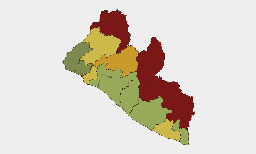
Situation Summary
Liberia remains a low-threat environment at the national level (composite score 9; #151 globally), with no confirmed widespread security events in the current reporting period. However, sub-national risk remains concentrated in the northeastern border counties—Nimba, Lofa, and Grand Gedeh—where persistent governance gaps, porous borders, and limited state presence create vulnerability to transnational crime and informal armed activity. The country's security picture is stable but fragmented, with significant variance by county and limited institutional capacity for rapid incident response.
Key Developments
- Kakata, Margibi County — September 20, 2026: A mass jailbreak at Kakata Central Prison resulted in the escape of more than 50 inmates. Security forces mounted search and recapture operations; the exact number remaining at large had not been officially confirmed by week's end. This incident highlights detention infrastructure vulnerabilities and raises questions about facility security protocols.
Highest-Risk Areas
The northeastern corridor—Nimba (92), Lofa (88), and Grand Gedeh (85)—accounts for the majority of structural risk, driven by limited state administrative presence, cross-border trafficking networks, and historical group-based tensions. Bong County (72) and Gbarpolu County (68) show elevated risk from similar factors. By contrast, Montserrado County (64), which contains the capital Monrovia, remains more stable due to higher security force density and international presence, though organized crime remains a concern. Risk in the southern counties (Sinoe, Grand Bassa, Margibi) is lower but not negligible; the Kakata incident underscores that localized capacity gaps can generate acute incidents even in moderate-risk zones.
How GeoBit Would Assist
Security teams with personnel or assets in Liberia should employ AOI Monitoring & Early Warning on the northeastern counties (Nimba, Lofa, Grand Gedeh) and on Monrovia's key infrastructure nodes to detect emerging incidents in near-real time. Network & Actor Analysis and OSINT fusion (Intel Sweep, X/Telegram feeds, multi-language search) can track informal armed groups, trafficking networks, and prison security developments. GIS & Spatial Analysis combined with Routing & Network Analysis supports contingency planning and identification of safe transit corridors and alternate routes for mobile teams, particularly in high-risk counties.
7-Day Outlook
No major security escalation is anticipated in the immediate term; the Kakata jailbreak appears to be a localized incident without broader institutional connotations. However, the northeastern border region will continue to require sustained monitoring for cross-border trafficking, informal group activity, and resource-driven tensions. Risk levels are unlikely to shift significantly in the next 7–10 days absent a major political or security shock.
Highest-Risk Areas — Ranked
| # | State / Region | Risk |
|---|---|---|
| 1 | Nimba County | 92 |
| 2 | Lofa County | 88 |
| 3 | Grand Gedeh County | 85 |
| 4 | River Gee County | 83 |
| 5 | Bong County | 72 |
| 6 | Gbarpolu County | 68 |
| 7 | Grand Kru County | 65 |
| 8 | Montserrado County | 64 |
| 9 | Rivercess County | 58 |
| 10 | Sinoe County | 55 |
| 11 | Margibi County | 52 |
| 12 | Grand Bassa County | 48 |
Sources
Previous Weekly Briefs
A new Liberia brief is written every Monday, covering the week — each with its own risk map and downloadable CSV. Use the calendar to go further back.
- September 15, 2026
- September 8, 2026
- September 2, 2026
- August 31, 2026
- August 28, 2026
- August 26, 2026
- August 24, 2026
📅 Browse past briefs by calendar →
Highlighted days have a brief. Tap a day for that day's map & analysis, or “csv” for that day's dataset ($5).
Atlas — our AI intelligence desk — emails them this snapshot personally. Nothing else, no list.