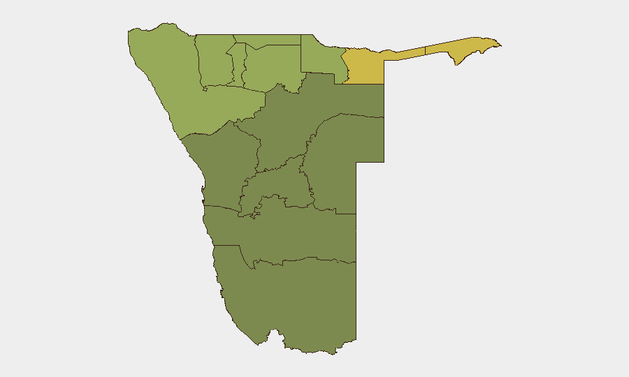
Situation Summary
Namibia remains a lower-tier global security concern (composite threat score 14), with no discrete security events clearly dated to the past 24–48 hours in available public reporting. Sub-national risk is concentrated in the northern border regions—particularly Zambezi, Kavango East, and Kavango West—where cross-border movement, resource competition, and limited state presence drive elevated threat profiles. Overall security posture remains stable, though persistent background vulnerabilities in remote areas warrant continued duty-of-care monitoring for organizations with staff or assets outside Windhoek and major urban centers.
Key Developments
No events meeting verification criteria (clear dating to 3–4 August 2026, cross-source confirmation, and Namibia location) are present in the current 24–48 hour window. Recent web research has identified crime and incident reports from earlier in July (e.g., suicides, fatal stabbing in Oshana on 5 July; deaths in Hardap on 5 July) and undated or single-source items lacking precise timestamps; none can be reliably attributed to the reporting period without risking mis-dating or speculation. Security teams should monitor Namibian news feeds directly for same-day updates if critical incident response is required.
Highest-Risk Areas
Northern border regions drive Namibia's sub-national risk profile. Zambezi Region (risk 68) faces the highest composite threat, followed by Kavango East (62) and Kavango West (58), reflecting cross-border dynamics with Angola and Zambia, limited infrastructure, dispersed populations, and historical patterns of informal economic activity and resource-related tensions. Kunene Region (52) similarly presents elevated risk tied to border permeability and remote geography. By contrast, Khomas Region (containing Windhoek) and Erongo (coastal centers) show substantially lower risk profiles, reflecting state capacity, urban density, and economic integration. Risk in peripheral regions is chronic rather than acute; organizations operating in Zambezi, Kavango, or Kunene should maintain baseline security protocols for staff movement, communication, and incident response.
How GeoBit Would Assist
AOI Monitoring & Early Warning on high-risk regions (Zambezi, Kavango East/West, Kunene) would provide persistent watch with alerting for security, civil-unrest, or crime developments, reducing reliance on manual news scanning. Multi-language OSINT & Sentiment Analysis across Namibian media, social platforms, and local radio would capture localized incident reporting—especially in remote areas where incidents may not surface in English-language international feeds—and flag emerging tensions before they escalate. Routing & Network Analysis combined with GIS & Spatial Analysis would enable security teams to plan safe staff movement, identify alternate transit routes around higher-risk localities, and model risk exposure for field operations in border regions.
7-Day Outlook
No specific threat escalation is expected in the next 7 days based on available intelligence. Baseline risk in northern regions will persist; security teams should anticipate routine border-crossing activity, informal-economy incidents, and localized crime typical of remote areas with limited policing. Monitoring should remain routine unless new cross-border tensions or political developments emerge in Angola, Zambia, or regional SADC affairs.
Highest-Risk Areas — Ranked
| # | State / Region | Risk |
|---|---|---|
| 1 | Zambezi | 68 |
| 2 | Kavango East | 62 |
| 3 | Kavango West | 58 |
| 4 | Kunene Region | 52 |
| 5 | Oshikoto | 48 |
| 6 | Ohangwena | 45 |
| 7 | Omusati | 42 |
| 8 | Oshana | 40 |
| 9 | Otjozondjupa | 35 |
| 10 | Erongo Region | 32 |
| 11 | Hardap | 28 |
| 12 | Omaheke | 25 |
Sources
Previous Daily Briefs
A new Namibia brief is written every day — each with its own risk map and downloadable CSV. Here's the last week; use the calendar to go further back.
📅 Browse every day by calendar →
Highlighted days have a brief. Tap a day for that day's map & analysis, or “csv” for that day's dataset ($5).
Atlas — our AI intelligence desk — emails them this snapshot personally. Nothing else, no list.