Situation Summary
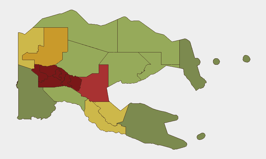
Papua New Guinea maintains a composite threat score of 21, reflecting endemic criminality, gang violence, and localized intercommunal conflict rather than a national security emergency. No discrete security incidents meeting verification criteria (specific date, location, cross-confirmation) have been reliably documented in the past 24–48 hours across open sources. The threat landscape remains concentrated in the Highlands provinces, where gun ownership, tribal disputes, and weak state presence sustain persistent violence; structural risks—including upcoming electoral processes, informal-sector weaponry, and limited police capacity—continue to shape medium-term outlook.
Key Developments
No incidents with verified dates of 4–5 August 2026 and cross-source confirmation are currently visible in open-source intelligence feeds.
Recent reporting gaps do not indicate security improvement; rather, they reflect the baseline difficulty of real-time incident confirmation in remote and under-resourced provinces. Security teams should note that absence of reporting often precedes discovery of significant incidents, particularly in the Highlands and in Port Moresby's informal settlements where communications infrastructure is limited.
Historical context (for situational awareness, not current developments):
- 11 June 2026: Armed disturbance involving Bomana Correctional Service personnel and firearms distribution into Port Moresby; 20 officers held without bail.
- 27 June 2026: Police Tactical Group "Operation KUMUL 23" conducted Enga Province patrols targeting illegal firearms and violent offenders.
- Late July 2026: Gun amnesty and policing initiatives in Enga Province continued; outcomes not yet formally reported.
Highest-Risk Areas
The top four provinces—Southern Highlands (risk 98), Enga (96), Hela (94), and Eastern Highlands (92)—account for the majority of documented tribal violence, gun-related incidents, and conflict-driven displacement in Papua New Guinea. These regions share common drivers: limited state presence, customary law enforcement competing with formal police, informal small-arms circulation, and intercommunal land and tribal disputes that frequently escalate to lethal force. The National Capital District (risk 85), while lower-ranked than the Highlands cluster, concentrates gang activity, organized crime, and informal-settlement violence affecting Port Moresby's business and expatriate communities. Morobe (78) and East Sepik (72) present secondary elevated risk, primarily linked to criminal networks and localized gang activity rather than tribal conflict.
How GeoBit Would Assist
Corporate security and duty-of-care teams in Papua New Guinea should employ AOI Monitoring & Early Warning (persistent watch on Highlands provinces and Port Moresby with near-real-time alerting on unrest, displacement, or police operations), Intel Sweep (daily fusion of local media, radio SIGINT, and social-media signals to detect nascent incidents before mainstream reporting), and Routing & Network Analysis (alternative journey planning and supply-chain resilience for operations in Enga, Hela, and Eastern Highlands). These capabilities collectively reduce the lag between incident onset and corporate awareness, enabling faster protective action for personnel and assets.
7-Day Outlook
Threat levels in the Highlands provinces are expected to remain elevated and stable over the next seven days, with no indicators of immediate, large-scale escalation or de-escalation. Electoral preparations and ongoing police operations (Operation KUMUL, Enga gun amnesty) may generate localized friction and temporary movement disruptions. Security teams should maintain heightened vigilance in Southern Highlands and Enga, where tribal tensions and informal weaponry create conditions for rapid incident onset with minimal warning.
Highest-Risk Areas — Ranked
| # | State / Region | Risk |
|---|---|---|
| 1 | Southern Highlands | 98 |
| 2 | Enga | 96 |
| 3 | Hela | 94 |
| 4 | Eastern Highlands | 92 |
| 5 | Western Highlands | 90 |
| 6 | Jiwaka | 88 |
| 7 | National Capital District | 85 |
| 8 | Simbu | 82 |
| 9 | Morobe | 78 |
| 10 | East Sepik | 72 |
| 11 | Sandaun | 68 |
| 12 | Oro | 66 |
Sources
Previous Daily Briefs
A new Papua New Guinea brief is written every day — each with its own risk map and downloadable CSV. Here's the last week; use the calendar to go further back.
📅 Browse every day by calendar →
Highlighted days have a brief. Tap a day for that day's map & analysis, or “csv” for that day's dataset ($5).
Atlas — our AI intelligence desk — emails them this snapshot personally. Nothing else, no list.