Situation Summary
Solomon Islands remains in a low-incident security environment with no corroborated reports of civil unrest, armed conflict, major crime spikes, or critical infrastructure failures in the last 24–48 hours. The country's composite threat score of 7 (ranked #146 globally) reflects baseline risks centered in the capital region and surrounding provinces rather than acute, active crises. Seismic activity and maritime crime remain the primary persistent hazards; neither has generated immediate operational disruption as of 24 August 2026.
Key Developments
- Offshore, Temotu Province (127 km west of Lata) – 24 Aug 2026, 08:32 local time: A magnitude 5.3 earthquake at 10 km depth was recorded. No reports of tsunamis, casualties, or infrastructure damage have been confirmed in available open sources.
- Exclusive Economic Zone, offshore Solomon Islands – 19 Aug 2026 (updated 24 Aug 2026): Australian Defence Force participation in Operation Island Chief, a Pacific fisheries surveillance operation, identified 19 vessels of interest and reported suspicious maritime activity to regional authorities as part of routine enforcement against illegal, unreported, and unregulated (IUU) fishing and transnational maritime crime. No civilian impact or escalation reported.
- Country-wide – 23–24 Aug 2026: Open-source security monitoring confirms low incident activity with no corroborated reports of unrest, clashes, crime spikes, or infrastructure failures during the 24–48-hour window.
Highest-Risk Areas
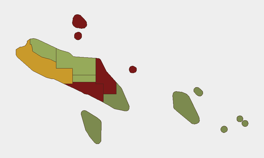
Honiara (risk score 92) and Guadalcanal Province (88) drive the country's elevated sub-national risk profile, followed by Malaita (85). These three regions account for the majority of historical civil unrest, gang-related violence, and criminal activity in Solomon Islands. Risk declines sharply in peripheral provinces; Temotu, Rennell and Bellona, and Makira-Ulawa present significantly lower threat scores. The concentration of risk in the capital and central provinces reflects urbanization, population density, and historical flashpoints around resource competition and tribal tensions, though no acute incidents are currently active.
How GeoBit Would Assist
Security teams with personnel or assets in Solomon Islands should leverage AOI Monitoring & Early Warning to establish persistent surveillance of Honiara and Guadalcanal, with alerts configured for civil unrest, protest activity, or gang violence. Maritime & Aviation Tracking combined with OSINT Fusion & Corroboration (including X/Twitter, open-source feeds, and multi-language search) would enable continuous monitoring of IUU fishing activity, transnational crime networks, and maritime border incidents. GIS & Spatial Analysis and Satellite & Imagery Analysis support facility security and route planning in high-risk urban areas, while Routing & Network Analysis identifies alternative movement corridors to avoid hotspots.
7-Day Outlook
No acute security deterioration is anticipated in the near term; the security environment is expected to remain stable and low-incident over the next seven days. Routine maritime enforcement, seismic monitoring, and baseline crime prevention should continue. Teams should maintain standard duty-of-care protocols for Honiara and Guadalcanal and monitor for any escalation linked to seasonal gang activity or political developments.
Highest-Risk Areas — Ranked
| # | State / Region | Risk |
|---|---|---|
| 1 | Honiara | 92 |
| 2 | Guadalcanal | 88 |
| 3 | Malaita | 85 |
| 4 | Western | 72 |
| 5 | Choiseul | 58 |
| 6 | Isabel | 52 |
| 7 | Central Province | 48 |
| 8 | Makira-Ulawa | 38 |
| 9 | Rennell and Bellona | 22 |
| 10 | Temotu | 18 |
Sources
Previous Daily Briefs
A new Solomon Islands brief is written every day — each with its own risk map and downloadable CSV. Here's the last week; use the calendar to go further back.
- August 22, 2026
- August 20, 2026
- August 18, 2026
- August 16, 2026
- August 14, 2026
- August 12, 2026
- August 10, 2026
📅 Browse every day by calendar →
Highlighted days have a brief. Tap a day for that day's map & analysis, or “csv” for that day's dataset ($5).
Atlas — our AI intelligence desk — emails them this snapshot personally. Nothing else, no list.