Situation Summary
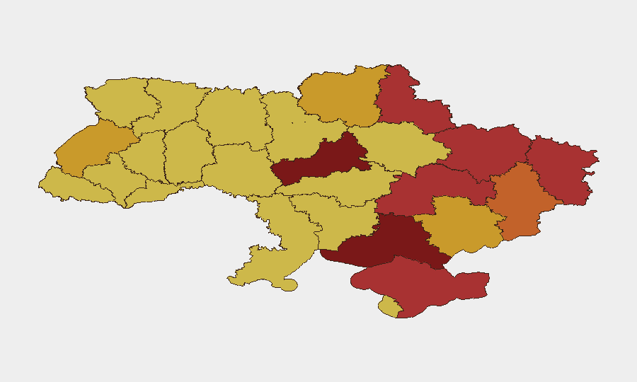
Ukraine remains at composite threat level 3 globally, driven by sustained conventional military operations across the eastern and central regions. Signal activity over the past 48 hours indicates continued high-tempo conflict, with reported strikes on civilian infrastructure in multiple population centers. The sub-national risk profile shows critical concentration in Cherkasy Oblast and Kyiv city, with secondary hotspots across the eastern corridor from Kharkiv through Donetsk and into the south.
Key Developments
- Zaporizhzhia city, 30 June 2026: Explosions reported in Ukrainian-controlled territory; EADaily/Ukrinform confirm "another explosion" in the city on 30 June with no casualty details yet available. *Risk type: infrastructure / conflict*.
- Dnipro, Dnipropetrovsk Oblast (recent, undated): Missile strike on infrastructure reported by Sky News/Independent citing Ukrainian officials; 5 killed, 29 injured. Grouped in "recent Russian strikes" cluster but precise timestamp unavailable. *Risk type: civilian casualties / critical infrastructure*.
- Zaporizhzhia city (recent, undated): Attack on civilian minibus reported; 3 killed, 6 injured including a child. Consistent with pattern of strikes on civilian transport noted by Sky News/Independent. *Risk type: civilian / transport targeting*.
- Sumy region—northeastern areas (recent, undated): Ukrainian National Police reports Russian drone attacks killing two elderly civilians (ages 69 and 77). Part of the same recent strike sequence but exact date unclear. *Risk type: rural targeting / drone threat*.
- Monaco, 29–30 June (last 48h window): Ukrainian oligarch Vadym Yermolaiev (sanctioned by Kyiv) injured in explosion along with two others including a minor, per Deutsche Welle. *Risk type: targeted violence / diaspora security*.
- Poland (timing unclear, likely recent): Polish Internal Security Agency deported nine Ukrainians and two Belarusians on suspicion of involvement in Russia-funded protests by Ukrainian refugees. *Risk type: diaspora legal / political influence*.
Highest-Risk Areas
Cherkasy Oblast and Kyiv city dominate the risk ranking (scores 100 and 97.2), reflecting both active military operations and sustained strike activity on civilian infrastructure and transport. The eastern military corridor—encompassing Kharkiv, Luhansk, Donetsk, and Dnipropetrovsk oblasts—remains persistently elevated (scores 75–79+), consistent with frontline operations and reported missile/drone targeting of critical infrastructure. Zaporizhzhia (71.4), despite lower ranking, shows recent explosive activity and civilian targeting, indicating concentrated near-term threat density in that city specifically. Southern regions including Kherson (80.7) and occupied Crimea (77) remain elevated due to ongoing conventional military pressure and cross-regional strike patterns.
How GeoBit Would Assist
Corporate security teams with personnel or assets in Ukraine would employ AOI Monitoring & Early Warning on high-risk oblasts (Cherkasy, Kyiv, Zaporizhzhia) to track real-time conflict activity and strike patterns; Battle Mapping and Force Structure tracking to understand tactical movement and frontline proximity; and Conflict & Military intelligence feeds for verified incident timestamps and damage assessment. Routing & Network Analysis supports alternative journey planning for staff movement, while OSINT Fusion (X/Telegram monitoring, news corroboration) accelerates verification of unconfirmed strikes and casualty reports when mainstream timestamps lag.
7-Day Outlook
Conventional military activity and strikes on civilian infrastructure are likely to continue at current or elevated tempo through early July. Risk concentration in Cherkasy and Kyiv suggests those locations warrant heightened monitoring protocols for corporate presence; transport and supply-chain routing should assume infrastructure degradation in regional hubs (Dnipro, Zaporizhzhia). No near-term de-escalation signals are evident in current event signals or public statements.
Highest-Risk Areas — Ranked
| # | State / Region | Risk |
|---|---|---|
| 1 | Cherkasy Oblast | 100 |
| 2 | Kyiv | 97.2 |
| 3 | Kherson Oblast | 80.7 |
| 4 | Luhansk Oblast | 79.7 |
| 5 | Dnipropetrovsk Oblast | 79.5 |
| 6 | Kharkiv Oblast | 79.1 |
| 7 | Autonomous Republic of Crimea | 77 |
| 8 | Sumy Oblast | 76.4 |
| 9 | Donetsk Oblast | 75.1 |
| 10 | Lviv Oblast | 72.1 |
| 11 | Chernihiv Oblast | 72.1 |
| 12 | Zaporizhia Oblast | 71.4 |
Sources
Previous Daily Briefs
A new Ukraine brief is written every day — each with its own risk map and downloadable CSV. Here's the last week; use the calendar to go further back.
📅 Browse every day by calendar →
Highlighted days have a brief. Tap a day for that day's map & analysis, or “csv” for that day's dataset ($5).