Situation Summary
Uruguay remains a relatively stable jurisdiction globally (rank #158, composite threat score 5), but a sharp cluster of violent crime—including multiple homicides, armed robberies, and ATM explosions—has emerged across the Montevideo metropolitan area and select interior departments over the past 72 hours. The violence has involved organized tactics (explosives, firearms coordination, group attacks) and geographically concentrated incidents in high-density neighborhoods and commercial zones. The current trajectory shows sustained rather than de-escalating activity, with law enforcement responding actively but incidents continuing.
Key Developments
- Montevideo, Flor de Maroñas (2026-08-12): A 59-year-old man killed in a shooting; part of a cluster of homicides within a 24-hour window.
- Montevideo, Peñarol (2026-08-12): A 20-year-old man fatally shot in an attack involving approximately 30 gunshots; one of several fatal incidents reported simultaneously.
- Montevideo, Ciudad Vieja (2026-08-12): Two men shot near Maciel Hospital; one target was reportedly attacked a third time, indicating targeted repeat violence.
- Carmelo, Colonia (2026-08-11–12): A 27-year-old man fatally shot in the chest in a late-night incident; extends violence beyond the capital.
- Montevideo–Canelones (2026-08-10–11): Approximately 50 Cerro FC supporters allegedly boarded a UCOT bus; two men threatened the driver with a firearm and forced the vehicle to Intercambiador Belloni, indicating organized group coercion and weapon-use.
- Parque Miramar, Montevideo (2026-08-08–09): Four suspects arrested following an ATM explosion on Avenida de las Américas; police recovered explosives and weapons; one suspect is Uruguayan rapper Nahuel Montero and two are Chilean nationals.
- Rivera (2026-08-12): An 8-year-old boy died after being struck in the eye with a pellet from an air rifle; investigation ongoing.
Highest-Risk Areas
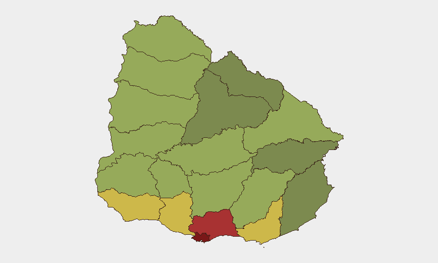
Montevideo (risk 92) and its adjacent department Canelones (78) account for the majority of current violent incidents and represent the primary risk corridor. Maldonado, San José, and Colonia (scores 68–62) show secondary but significant activity, with Colonia's Carmelo recording a recent homicide. The concentration in Montevideo reflects both population density and criminal organization presence; the geographic spread to interior departments (Colonia, Rivera) and inter-departmental coordination (Canelones–Montevideo) suggests organized activity extending beyond the capital. Commercial zones, transit hubs, and lower-income neighborhoods show elevated incident clustering.
How GeoBit Would Assist
Security teams with personnel or assets in Uruguay should deploy AOI Monitoring & Early Warning on high-risk zones (Montevideo neighborhoods, Canelones transit corridors, Colonia) to detect emerging incident patterns in real time. Network & Actor Analysis and OSINT fusion (X, Telegram, local news feeds) would identify organized criminal cells, their operational tactics (explosives, group tactics, targeted repeats), and cross-border involvement (Chilean nationals linked to recent robberies). Routing & Network Analysis would support duty-of-care teams in planning safer routes and identifying temporal/geographic "hot windows" for staff movements in Montevideo and Canelones.
7-Day Outlook
The 72-hour violence cluster and active law enforcement response suggest either a discrete criminal operation cycle or emerging gang/organizational activity. If the pattern sustains or spreads to secondary departments (Maldonado, Salto, Paysandú), risk scoring may warrant upward revision. Continued monitoring of arrest outcomes, weapons seizures, and cross-border coordination with Chilean authorities will clarify intent and likely duration.
Highest-Risk Areas — Ranked
| # | State / Region | Risk |
|---|---|---|
| 1 | Montevideo | 92 |
| 2 | Canelones | 78 |
| 3 | Maldonado | 68 |
| 4 | San José | 64 |
| 5 | Colonia | 62 |
| 6 | Soriano | 58 |
| 7 | Río Negro | 56 |
| 8 | Salto | 54 |
| 9 | Artigas | 52 |
| 10 | Paysandú | 50 |
| 11 | Florida | 48 |
| 12 | Flores | 46 |
Sources
Previous Daily Briefs
A new Uruguay brief is written every day — each with its own risk map and downloadable CSV. Here's the last week; use the calendar to go further back.
- August 12, 2026
- August 11, 2026
- August 10, 2026
- August 9, 2026
- August 8, 2026
- August 7, 2026
- August 6, 2026
📅 Browse every day by calendar →
Highlighted days have a brief. Tap a day for that day's map & analysis, or “csv” for that day's dataset ($5).
Atlas — our AI intelligence desk — emails them this snapshot personally. Nothing else, no list.