Situation Summary
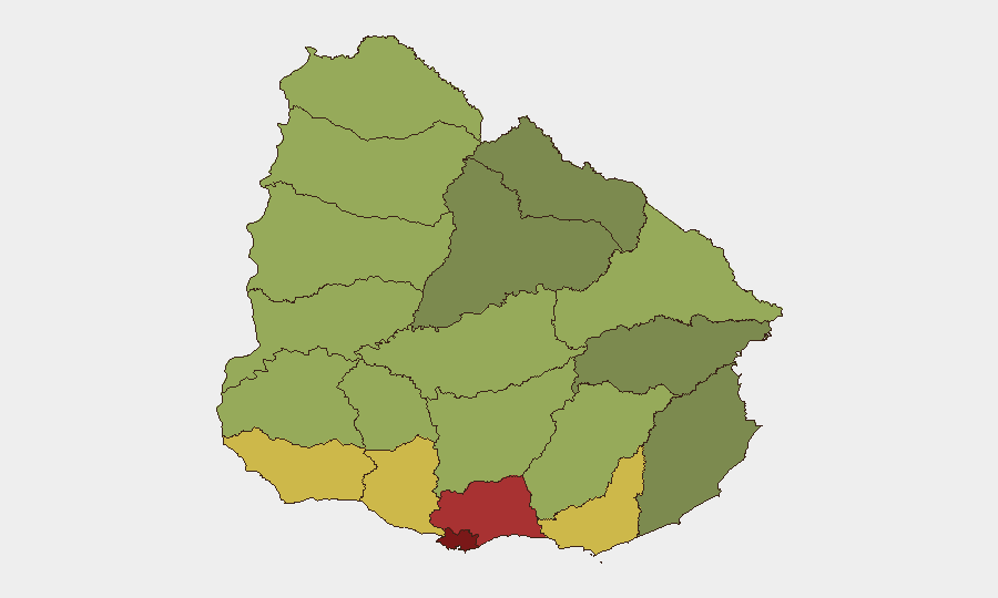
Uruguay remains a relatively low-threat environment globally (rank #164), but concentrated violence in Montevideo and adjacent departments signals a deteriorating micro-security picture in urban cores. Over 48 hours (28–29 August), multiple homicides and a fatal residential fire indicate a localised spike in civilian casualties. While the national composite threat score remains 6, departmental concentration—particularly Montevideo (risk 92)—demands heightened vigilance in corporate operations and employee movements within the capital and greater metropolitan area.
Key Developments
- 28 August, Barrio Ituzaingó (Montevideo). A 29-year-old male fatally shot in the head during early morning hours; investigation ongoing. Circumstances and motive under review.
- 28 August, Barrio Los Sueños (Montevideo). A 15-year-old killed by multiple gunshot wounds, part of a three-victim violence cluster within 24 hours across adjacent barrios. Incident pattern suggests possible territorial or gang-related activity.
- 28 August, Parque Guaraní (Montevideo). An adult male found dead from gunshot wounds on a public street; third homicide in the cluster spanning adjacent neighbourhoods on the same date.
- 28 August, Barrio 40 Semanas (Montevideo). Residential fire claimed two lives; emergency services responded. Cause and circumstances under investigation.
- 29 August, Rambla Euskal Erria / Mataojo intersection (Montevideo). A 40-year-old male allegedly under the influence of alcohol stepped into roadway; incident under investigation. (Severity and outcome not yet fully clarified in available data.)
Highest-Risk Areas
Montevideo dominates the risk landscape at score 92, reflecting the three homicides and fire fatalities documented over 48 hours and an apparent escalation in street violence. Canelones (78) and Maldonado (68) follow, but Montevideo accounts for the majority of recent event clustering. The concentration of corporate offices, residential expatriate communities, and transportation hubs in Montevideo means that even localised barrio-level violence—if it expands or shifts toward commercial zones—poses duty-of-care and operational continuity risks. San José, Colonia, and Soriano show elevated secondary risk; however, the northern border departments (Artigas, Salto, Paysandú) remain below 55, suggesting limited cartel or cross-border criminal activity at present.
How GeoBit Would Assist
Intel Sweep and X/Twitter OSINT would provide real-time confirmation of barrio-level incidents, gang affiliations, and territorial claims, allowing security teams to map no-go zones and adjust routing dynamically. AOI (Area-of-Interest) Monitoring & Early Warning on Montevideo's highest-risk barrios—Ituzaingó, Los Sueños, Parque Guaraní, 40 Semanas—with persistent alerting would flag further violence spikes, fires, or police operations before they impact corporate facilities or commuter routes. Routing & Network Analysis would generate alternative journey plans for employees avoiding identified hotspots, reducing exposure during periods of escalation.
7-Day Outlook
If the 28–29 August cluster represents a localised dispute or gang consolidation rather than systemic escalation, violence may stabilise within days once territorial boundaries are re-established. However, absence of official statements or arrests suggests investigation is incomplete; ongoing retaliation or related incidents in adjacent barrios remain possible over the next 5–7 days. Corporate teams should maintain heightened situational awareness in Montevideo and defer non-essential movement into affected barrios pending clarification of motive and scope.
Highest-Risk Areas — Ranked
| # | State / Region | Risk |
|---|---|---|
| 1 | Montevideo | 92 |
| 2 | Canelones | 78 |
| 3 | Maldonado | 68 |
| 4 | San José | 64 |
| 5 | Colonia | 62 |
| 6 | Soriano | 58 |
| 7 | Río Negro | 56 |
| 8 | Salto | 54 |
| 9 | Artigas | 52 |
| 10 | Paysandú | 50 |
| 11 | Florida | 48 |
| 12 | Flores | 46 |
Sources
Previous Daily Briefs
A new Uruguay brief is written every day — each with its own risk map and downloadable CSV. Here's the last week; use the calendar to go further back.
- August 30, 2026
- August 29, 2026
- August 28, 2026
- August 27, 2026
- August 26, 2026
- August 25, 2026
- August 24, 2026
📅 Browse every day by calendar →
Highlighted days have a brief. Tap a day for that day's map & analysis, or “csv” for that day's dataset ($5).
Atlas — our AI intelligence desk — emails them this snapshot personally. Nothing else, no list.