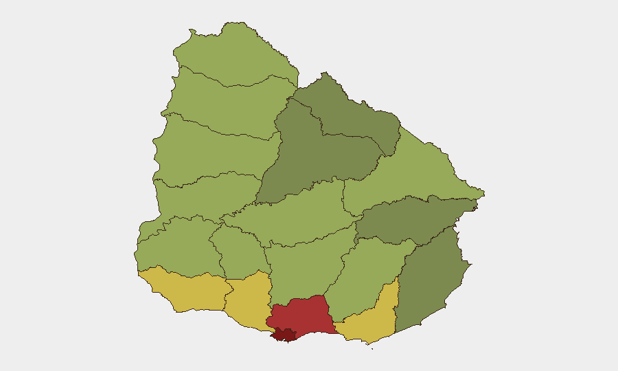
Situation Summary
Uruguay remains a relatively low-threat environment globally (rank #165), but Montevideo is experiencing a sharp spike in homicidal violence over the past week, with at least six confirmed deaths in the past 48 hours across multiple neighborhoods. Gang-related activity, armed robbery, and inter-cartel conflict appear to be driving elevated lethality in the capital and surrounding Canelones department. Police operations (Operativo Atenea, Operation Masivo) targeting Los Colorados and Los Suárez gangs suggest enforcement is active, but the pace of civilian fatalities indicates operational containment remains incomplete.
Key Developments
- Montevideo, Barrio Marconi (Enrique Castro y Burgueño) – 28–29 Aug: A 17-year-old male died at Hospital Pasteur from injuries sustained in a drive-by shooting on Friday afternoon; multiple shell casings recovered at scene.
- Montevideo, Barrio Ituzaingó – early 28 Aug: A 29-year-old man shot in the head and killed; homicide investigation ongoing.
- Montevideo, Barrio Los Sueños – 28 Aug: A 15-year-old fatally shot multiple times; separate incident same day.
- Montevideo, Parque Guaraní – 28 Aug: Adult male found dead from gunshot wounds in public street; distinct investigation.
- Montevideo, Barrio 40 Semanas – 28 Aug: Two deaths confirmed in a residential fire; emergency services responded and police initiated investigation.
- Montevideo, Barrio Reus – 26 Aug (reported within 48h): Man and woman found dead in same residence; active investigation by Jefatura de Policía.
- Montevideo, Barrio Marconi (midday 28 Aug): ShotSpotter detected gunfire; four shell casings and two cartridges recovered; no reported injuries or arrests.
Highest-Risk Areas
Montevideo (risk 92) dominates the threat landscape, accounting for all confirmed deaths in the past 48 hours and the majority of recent armed incidents. The capital's vulnerability reflects gang presence, turf competition, and a concentration of commercial targets (bank robberies on 25 Aug). Canelones (risk 78), bordering Montevideo, is the secondary hotspot, likely serving as both a spillover zone and operational base for criminal networks. Together, these two departments account for the majority of lethal violence; the remaining ten departments show substantially lower incident density and fatality rates, suggesting risk is highly concentrated in the metropolitan core.
How GeoBit Would Assist
Corporate security teams operating in or transiting through Montevideo should deploy AOI Monitoring & Early Warning on high-risk neighborhoods (Barrio Marconi, Los Sueños, Ituzaingó, Parque Guaraní) to capture real-time ShotSpotter activity, police deployments, and incident clusters. Network & Actor Analysis on Los Colorados and Los Suárez gang structures and conflict drivers would inform route planning and facility-security adjustments. Routing & Network Analysis (alternative journey planning) is critical for staff commuting or site visits in Montevideo, enabling avoidance of active conflict zones during peak-violence windows.
7-Day Outlook
The cluster of six homicides in 48 hours suggests either an escalation in inter-gang conflict or a temporary surge in police enforcement spillover; both scenarios typically exhibit 5–10 day secondary peaks as rival networks retaliate or consolidate territory. Canelones and outer Montevideo neighborhoods should be monitored for displacement violence. Unless sustained police presence (Operation Masivo scale) remains active, lethal-violence levels are likely to remain elevated through early September.
Highest-Risk Areas — Ranked
| # | State / Region | Risk |
|---|---|---|
| 1 | Montevideo | 92 |
| 2 | Canelones | 78 |
| 3 | Maldonado | 68 |
| 4 | San José | 64 |
| 5 | Colonia | 62 |
| 6 | Soriano | 58 |
| 7 | Río Negro | 56 |
| 8 | Salto | 54 |
| 9 | Artigas | 52 |
| 10 | Paysandú | 50 |
| 11 | Florida | 48 |
| 12 | Flores | 46 |
Sources
Previous Daily Briefs
A new Uruguay brief is written every day — each with its own risk map and downloadable CSV. Here's the last week; use the calendar to go further back.
- August 28, 2026
- August 27, 2026
- August 26, 2026
- August 25, 2026
- August 24, 2026
- August 23, 2026
- August 22, 2026
📅 Browse every day by calendar →
Highlighted days have a brief. Tap a day for that day's map & analysis, or “csv” for that day's dataset ($5).
Atlas — our AI intelligence desk — emails them this snapshot personally. Nothing else, no list.