Situation Summary
Burkina Faso remains at elevated security risk (global rank #20, composite score 64) driven primarily by ongoing insurgency activity in northern and Sahel regions. Recent 24–48-hour developments reflect a mix of diplomatic friction with neighbours, localised military pressure on junta forces, and infrastructure hardening measures, but no confirmed major attacks in the immediate past two days. The threat environment is characterised by sustained militant pressure rather than acute escalation, though border-zone volatility and cross-border tensions with Ghana warrant close monitoring.
Key Developments
- Ouagadougou, 22 June 2026: Burkina Faso's foreign ministry summoned the EU representative to lodge a formal protest against what the government characterised as "false statements" and external interference in internal affairs, signalling heightened diplomatic sensitivity and potential erosion of Western diplomatic relations.
- Bilateral tensions (national level), 22 June 2026: A Burkina Faso Major General and Ghanaian authorities issued public statements reflecting heightened friction and potential border-security concerns, indicating fresh bilateral tension that may affect cross-border movement and regional security cooperation.
- Military positions (peripheral/unspecified regions), 22–23 June 2026: Social media reports documented recent attacks on Burkina Faso military installations, reflecting sustained militant pressure on junta forces in secondary operational areas.
- Border corridors (external frontiers), 22–23 June 2026: Burkina Faso has deployed modern surveillance towers along key border sectors as part of an active security hardening campaign; Côte d'Ivoire simultaneously called for joint border patrols, indicating shared regional concern over cross-border threat transit.
- Energy infrastructure (national), 22–23 June 2026: Government announcement of a planned 200 MW power plant framed as a strategic "energy sovereignty" initiative, relevant to medium-term infrastructure resilience and potential asset-protection planning.
- Security posture assessment (21–22 June 2026): No verifiable, location-specific armed clashes or major civil unrest documented in the past 24–48 hours despite sustained high insurgency risk, suggesting a relative operational lull rather than reduced threat.
Highest-Risk Areas
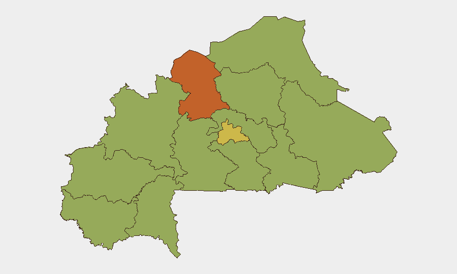
The North region (risk score 74.6) and Centre (61.5) dominate the sub-national risk hierarchy and are the primary drivers of Burkina Faso's global threat ranking. The North's elevated score reflects persistent insurgent presence and militant infrastructure; the Centre's score, while lower, signals spill-over risk affecting the capital region and major transport corridors. The remaining ten regions cluster at 44.6, indicating a broad but secondary baseline of exposure across the country. For duty-of-care purposes, North and Centre regions require heightened travel restrictions, asset monitoring, and incident-response readiness; activities in lower-ranked regions remain feasible with standard precautions but are not risk-free.
How GeoBit Would Assist
Security teams should deploy AOI Monitoring & Early Warning on North and Centre regions to detect new militant activity, checkpoints, or force movements in near-real time. Network & Actor Analysis combined with OSINT fusion (X/Twitter, Telegram, local media cross-reference) would enable rapid corroboration of unconfirmed attack reports and assessment of diplomatic friction escalation patterns. Routing & Network Analysis would support alternative route planning for personnel and cargo transiting between Ouagadougou, Ghana, and Côte d'Ivoire in light of current border tensions.
7-Day Outlook
Insurgent pressure on military positions is likely to remain elevated in the North and eastern periphery; no imminent major escalation is indicated, but the diplomatic tensions with Ghana and EU friction may create secondary complications for cross-border operations and humanitarian/diplomatic access. Continued border infrastructure deployment and heightened Ghana–Burkina Faso bilateral friction suggest a consolidation of fragmented security postures rather than a move toward stability. Live monitoring for any location-specific clashes, checkpoint establishment, or further diplomatic incidents is essential.
Highest-Risk Areas — Ranked
| # | State / Region | Risk |
|---|---|---|
| 1 | North | 74.6 |
| 2 | Centre | 61.5 |
| 3 | Upper-Basins | 44.6 |
| 4 | Boucle du Mouhoun | 44.6 |
| 5 | Central-West | 44.6 |
| 6 | Central-South | 44.6 |
| 7 | Central-East | 44.6 |
| 8 | Waterfalls | 44.6 |
| 9 | Southwest | 44.6 |
| 10 | Sahel | 44.6 |
| 11 | Central-North | 44.6 |
| 12 | East | 44.6 |
Sources
Previous Daily Briefs
A new Burkina Faso brief is written every day — each with its own risk map and downloadable CSV. Here's the last week; use the calendar to go further back.
📅 Browse every day by calendar →
Highlighted days have a brief. Tap a day for that day's map & analysis, or “csv” for that day's dataset ($5).