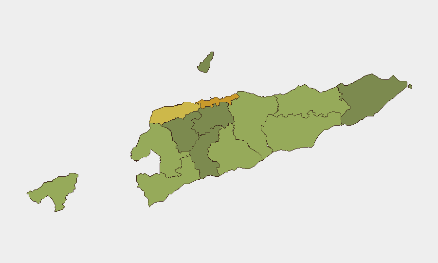
Situation Summary
East Timor remains a low-threat environment with no documented security incidents, civil unrest, or infrastructure disruptions in the last 24–48 hours. The country's composite threat score of 4 reflects stable conditions across most districts. Routine diplomatic engagement between Timor‑Leste and Indonesia continues without security implications. The security posture is expected to remain stable in the near term absent major external or domestic political shocks.
Key Developments
- Jakarta, 13 July 2026: Ambassador Roberto Sarmento de Oliveira Soares (Timor‑Leste) held multilateral discussions with Indonesian counterparts on regional cooperation and shared diplomatic priorities. This is routine diplomatic activity with no security risk indicators.
- No acute incidents reported: Open-source monitoring and humanitarian event datasets confirm zero political violence, demonstrations, civilian-targeting events, or security crises in Timor‑Leste during the 24–48-hour window.
- No infrastructure or services disruptions: Water, power, telecommunications, and transport networks remain functional nationwide. No travel restrictions or checkpoints have been established.
Highest-Risk Areas
Dili (risk 72), Liquiçá (62), and Baucau (58) drive the national risk profile, reflecting the capital's higher population density, commercial activity, and historical vulnerability to localized gang and petty-crime dynamics. Liquiçá's elevated score reflects its proximity to the Oecussi-Ambeno enclave and legacy tensions; Baucau represents the eastern region's structural vulnerabilities. Remaining districts (Cova Lima through Aileu) show substantially lower composite risk, with rural and less-urbanized areas registering minimal current threat signatures. The risk gradient correlates with urbanization, population concentration, and historical crime/instability patterns rather than acute conflict or civil unrest.
How GeoBit Would Assist
Security and duty-of-care teams operating in Timor‑Leste would benefit from AOI Monitoring & Early Warning on high-risk municipalities (Dili, Liquiçá, Baucau) to flag emerging protest activity, gang violence, or civil unrest before it escalates. Intel Sweep and multi-language OSINT fusion across local media, social platforms, and event feeds would provide continuous low-noise situational awareness and early warning of political instability or infrastructure disruptions. Routing & Network Analysis can identify safe transit corridors in urban areas and alternative travel paths in case of localized incidents or checkpoint activity.
7-Day Outlook
No acute security triggers or political events are forecast for the next 7 days. Conditions are expected to remain stable, with routine government and diplomatic activity continuing. Monitor for any escalation in gang-related activity in Dili or secondary cities, though current indicators do not suggest imminent risk elevation.
Highest-Risk Areas — Ranked
| # | State / Region | Risk |
|---|---|---|
| 1 | Dili | 72 |
| 2 | Liquiçá | 62 |
| 3 | Baucau | 58 |
| 4 | Cova Lima | 55 |
| 5 | Bobonaro | 53 |
| 6 | Oecussi-Ambeno | 48 |
| 7 | Manufahi | 45 |
| 8 | Viqueque | 42 |
| 9 | Manatuto | 40 |
| 10 | Ainaro | 38 |
| 11 | Ermera | 36 |
| 12 | Aileu | 32 |
Sources
Previous Daily Briefs
A new East Timor brief is written every day — each with its own risk map and downloadable CSV. Here's the last week; use the calendar to go further back.
📅 Browse every day by calendar →
Highlighted days have a brief. Tap a day for that day's map & analysis, or “csv” for that day's dataset ($5).
Atlas — our AI intelligence desk — emails them this snapshot personally. Nothing else, no list.