Situation Summary
Guyana remains a stable, low-threat environment globally (rank #64 composite threat score 18) with no discrete security incidents reported in the last 24–48 hours. Sub-national risk concentration in the northern coastal regions—particularly Demerara-Mahaica and Cuyuni-Mazaruni—reflects underlying patterns of organized crime, trafficking, and resource-competition dynamics rather than active destabilization. The absence of tracked events in the current window does not indicate risk reduction; rather, it signals a period of operational dormancy typical of mid-year patterns in the region.
Key Developments
- No discrete security, crime, civil-unrest, or infrastructure incidents were verified in Guyana during the last 24–48 hours. Web research returned no corroborated incident reports from in-country sources.
- Regional geopolitical activity (Iran–U.S. tensions, UN Security Council scheduling) is monitored but does not constitute a direct Guyana-specific threat vector at this time.
- Personnel and asset-holders in-country should maintain routine situational awareness; the absence of current incidents does not reduce the baseline risk profile of high-risk districts.
Highest-Risk Areas
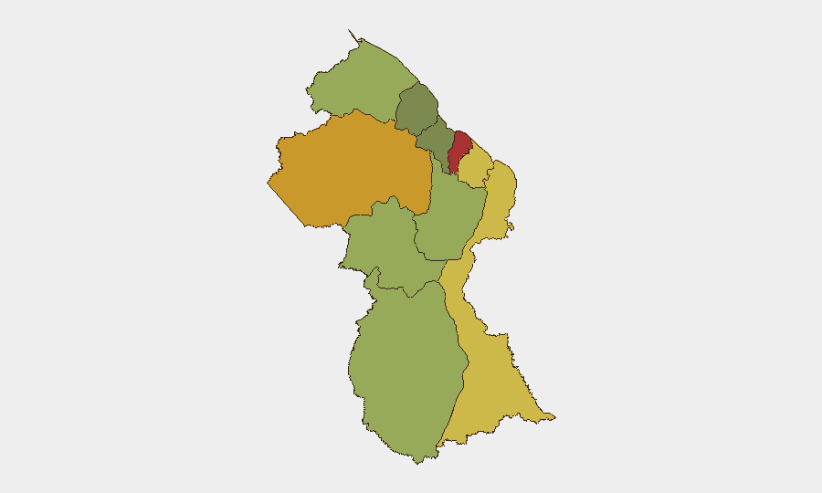
Demerara-Mahaica (risk 78) and Cuyuni-Mazaruni (risk 72) drive the sub-national risk ranking, reflecting concentrated human, trafficking, and organized-crime activity corridors. Demerara-Mahaica encompasses Georgetown and the coastal commercial zone—high population density, port activity, and informal-economy vulnerabilities create persistent exposure to petty crime, armed robbery, and narcotics transit. Cuyuni-Mazaruni, a remote hinterland region with mining and artisanal-gold extraction activity, is associated with turf competition, informal armed groups, and weak state presence. Mahaica-Berbice and East Berbice-Corentyne (risk 65 and 62 respectively) extend this risk profile along the coast and into the interior, where border-proximate vulnerabilities and river-based trafficking routes elevate threat density. Risk degradation with distance from these nodes is evident in the ranking; upper-interior and western regions (Potaro-Siparuni, Upper Takutu-Upper Essequibo) show substantially lower scores.
How GeoBit Would Assist
AOI Monitoring & Early Warning would track Demerara-Mahaica and Cuyuni-Mazaruni with persistent satellite and OSINT feeds to detect emergent incidents, unusual security force deployments, or informal-group activity before they escalate. Network & Actor Analysis combined with Intel Sweep (X/Twitter, Telegram, local media OSINT) would maintain real-time visibility on criminal and trafficking-group movements, leadership changes, and territorial disputes. Routing & Network Analysis would enable security teams to plan alternative routes and safe-haven positioning for personnel operating in high-risk districts, while Risk & Threat Assessment and GIS & Spatial Analysis tools would support duty-of-care planning and asset-protection protocols tailored to district-level and neighborhood risk variation.
7-Day Outlook
No imminent security escalation is forecast. The current low-incident reporting window is consistent with seasonal and operational patterns; however, the persistent baseline risk in northern coastal and hinterland regions means that exposure to crime, trafficking disruption, and informal-group activity remains material for corporate operations. Routine vigilance and early-warning monitoring should remain active.
Highest-Risk Areas — Ranked
| # | State / Region | Risk |
|---|---|---|
| 1 | Demerara-Mahaica | 78 |
| 2 | Cuyuni-Mazaruni | 72 |
| 3 | Mahaica-Berbice | 65 |
| 4 | East Berbice-Corentyne | 62 |
| 5 | Upper Demerara-Berbice | 58 |
| 6 | Potaro-Siparuni | 48 |
| 7 | Barima-Waini | 45 |
| 8 | Upper Takutu-Upper Essequibo | 42 |
| 9 | Pomeroon-Supenaam | 38 |
| 10 | Essequibo Islands | 35 |
Sources
Previous Daily Briefs
A new Guyana brief is written every day — each with its own risk map and downloadable CSV. Here's the last week; use the calendar to go further back.
📅 Browse every day by calendar →
Highlighted days have a brief. Tap a day for that day's map & analysis, or “csv” for that day's dataset ($5).
Atlas — our AI intelligence desk — emails them this snapshot personally. Nothing else, no list.