Situation Summary
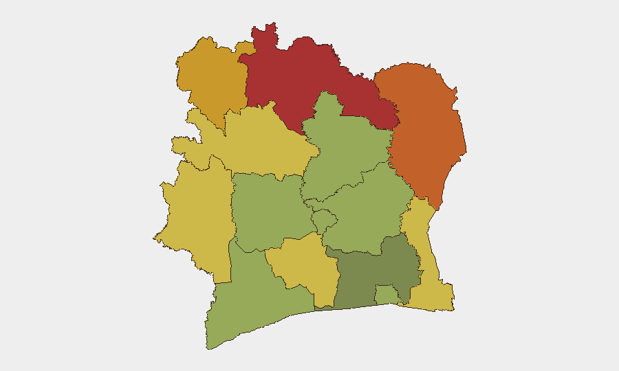
Ivory Coast remains at moderate composite threat level (#68 globally, score 25), with insurgency and terrorism as primary drivers. The country experienced a localized violent incident on 4–5 August in the southern Lagunes region; security forces responded and restored order. Northern border districts—particularly Savanes, Zanzan, and Denguélé—carry substantially elevated risk profiles (scores 78, 75, 72 respectively) due to persistent jihadist and insurgent activity, though confirmed incident reporting for the past 48 hours remains limited to the Kossandji event.
Key Developments
- Kossandji, Alépé District, Lagunes Region (4–5 August 2026) — A violent communal clash resulted in at least 3 confirmed deaths, multiple injuries, and property damage. Local security forces deployed and restabilized the area. The incident does not yet appear to be linked to organized jihadist activity but underscores localized communal tensions and security-force responsiveness.
Highest-Risk Areas
The northern tier of Ivory Coast—Savanes, Zanzan, Denguélé, and Comoé districts—dominates the risk landscape, with composite scores ranging from 78 to 70. These zones border Mali, Burkina Faso, and Guinea, where transnational jihadist and insurgent networks operate and periodically extend operations into Ivorian territory. Savanes in particular (risk 78) has been the recurring focal point for cross-border militant activity. Mid-country regions (Montagnes, Woroba, Gôh-Djiboua) present secondary but material risk (65–60), while the commercial and administrative heartland of Abidjan (risk 45) and southern coastal districts remain relatively more stable, though not immune to spillover criminal or communal violence.
How GeoBit Would Assist
Security and risk teams should deploy AOI Monitoring & Early Warning on the six highest-risk northern districts, with persistent satellite and OSINT feeds to detect force movements, camp activity, or weapons transfers before incidents occur. Intel Sweep (multi-language, X/Telegram, local news fusion) combined with sentiment & temporal analysis will provide 24–48 hour advance signals of communal or militant activity. For duty-of-care operations in central or southern zones, Routing & Network Analysis offers real-time alternative-route planning to avoid flash-violence zones and supply-chain disruption, while conflict mapping and border & disputed-territory search capabilities track active jihadist zones near staff or asset locations.
7-Day Outlook
Northern districts will remain under baseline elevated threat; no imminent mass-casualty event is evident, but cross-border militia activity typically intensifies in dry-season months (August–October). The Kossandji incident, if part of a communal-tension pattern rather than a singular clash, may see follow-on reprisal activity within 5–10 days; local monitoring is warranted. Abidjan and southern commercial corridors are forecast to remain operationally stable absent major political shock or jihadist spillover from the north.
Highest-Risk Areas — Ranked
| # | State / Region | Risk |
|---|---|---|
| 1 | Savanes District | 78 |
| 2 | Zanzan District | 75 |
| 3 | Denguélé District | 72 |
| 4 | Comoé District | 70 |
| 5 | Montagnes District | 68 |
| 6 | Woroba District | 65 |
| 7 | Gôh-Djiboua District | 60 |
| 8 | Sassandra-Marahoué District | 58 |
| 9 | Vallée du Bandama District | 55 |
| 10 | Bas-Sassandra District | 52 |
| 11 | Lacs District | 48 |
| 12 | Abidjan | 45 |
Sources
Previous Daily Briefs
A new Ivory Coast brief is written every day — each with its own risk map and downloadable CSV. Here's the last week; use the calendar to go further back.
📅 Browse every day by calendar →
Highlighted days have a brief. Tap a day for that day's map & analysis, or “csv” for that day's dataset ($5).
Atlas — our AI intelligence desk — emails them this snapshot personally. Nothing else, no list.