Situation Summary
Lebanon remains at elevated composite threat level (#16 globally, score 86) amid active Israeli–Hezbollah and Iran-linked military tensions. A deadly Israeli drone strike near Nabatieh on 2026-07-11–12 killed four civilians and marked the deadliest Israeli operation since the most recent ceasefire, signaling a material escalation in cross-border kinetic activity. Military mobilization, unconventional violence signals, and competing territorial demands across multiple state actors (Israel, Iran, Lebanon) indicate the risk environment is deteriorating rather than stabilizing.
Key Developments
- 2026-07-11–12 · Israeli Drone Strike, Nabatieh Governorate: BBC and Al Jazeera confirm a deadly Israeli airstrike near Nabatieh al-Fqa killed four civilians. Lebanese state media identified victims. Assessed as the deadliest Israeli strike since the preceding ceasefire arrangement, indicating a breach or collapse of de-escalation terms.
- 2026-07-11 · Military Mobilization and Unconventional Violence Signals: Multiple event signals logged for 2026-07-11 document Iran-linked military mobilization (IRAN vs SHIITE actors) and unconventional violence claims (LEBANON vs IRAN, ISRAEL vs IRAN), suggesting proxy and direct-action coordination across the Lebanon theater.
- 2026-07-11 · Conventional Military Force Activation: Both LEBANON vs ISRAEL and ISRAEL vs LEBANON conventional military force events logged same day, consistent with active air defense responses and reciprocal military posturing.
- 2026-07-12 · Small Arms Combat, Army Operations: ARMY vs IRAN small-arms combat logged 2026-07-12, suggesting ground-level engagement or tactical friction between Lebanese military units and Iran-backed forces.
- 2026-07-11 · Aerial Weapons Deployment: Lebanon logged aerial weapons event on 2026-07-11, indicative of rocket or drone activity by Lebanese or aligned forces; corroborated by continued Israeli airstrikes across multiple locations.
- 2026-07-11 · Territorial and Diplomatic Pressure: A demand event (LEBANON vs CYPRUS) and disapproval statement (ISRAEL vs LEBANON) logged same date; suggests concurrent maritime/EEZ disputes and formal diplomatic deterioration alongside kinetic escalation.
Highest-Risk Areas
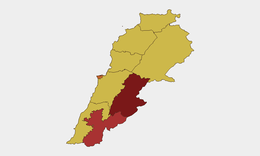
Beqaa Governorate (90.1) and Nabatieh Governorate (76.6) drive the country's composite threat ranking, reflecting concentrated Hezbollah infrastructure, Iranian military presence, and Israeli targeting. Beirut Governorate (74) reflects capital-city risk from potential retaliation, collateral effects, and political instability. North, Akkar, and Keserwan-Jbeil Governorates all register 60.1 due to diffuse sectarian tensions, arms smuggling, and proximity to Syria. The gap between top two zones and the remainder suggests threat is geographically concentrated in the Beqaa–Nabatieh corridor and capital.
How GeoBit Would Assist
Security teams should deploy AOI Monitoring & Early Warning with persistent watch on Beqaa and Nabatieh for Iranian militia movement and Israeli strike preparation; Intel Sweep and multi-language OSINT (X/Telegram, Lebanese media) for real-time event detection and cross-border messaging; and Conflict & Military mapping to track Israeli air-defense penetration patterns and Lebanese military response capacity. Routing & Network Analysis can identify safe transit corridors for personnel and assets away from high-threat zones.
7-Day Outlook
Kinetic escalation will likely continue through mid-July absent urgent diplomatic intervention. Israeli air operations in southern Lebanon and Beqaa are expected to intensify if Hezbollah or Iran-aligned forces sustain cross-border attacks. Risk of wider regional involvement (Syria, Iraq proxies) remains elevated; personnel in Beirut should prepare contingency movement plans and minimize exposure to military-sensitive locations.
Highest-Risk Areas — Ranked
| # | State / Region | Risk |
|---|---|---|
| 1 | Beqaa Governorate | 90.1 |
| 2 | Nabatieh Governorate | 76.6 |
| 3 | Beirut Governorate | 74 |
| 4 | North Governorate | 60.1 |
| 5 | Akkar Governorate | 60.1 |
| 6 | Keserwan-Jbeil Governorate | 60.1 |
| 7 | Mount Lebanon Governorate | 60.1 |
| 8 | South Governorate | 60.1 |
| 9 | Baalbek-Hermel Governorate | 60.1 |
Sources
Previous Daily Briefs
A new Lebanon brief is written every day — each with its own risk map and downloadable CSV. Here's the last week; use the calendar to go further back.
📅 Browse every day by calendar →
Highlighted days have a brief. Tap a day for that day's map & analysis, or “csv” for that day's dataset ($5).
Atlas — our AI intelligence desk — emails them this snapshot personally. Nothing else, no list.