Situation Summary
Lesotho remains a low-threat environment with a composite threat score of 6 (ranked #150 globally) and no recorded security incidents in the current monitoring window. Structural vulnerabilities—including gender-based violence, seasonal weather disruption, and ongoing judicial proceedings—persist but have not escalated into acute crisis. No major protests, civil unrest, or crime spikes have been reported in the last 24–48 hours.
Key Developments
No discrete security incidents, unrest events, or travel-risk changes in Lesotho were confirmed within the last 24–48 hours (as of 18 August 2026). Web and social content searches did not surface new protests, infrastructure failures, major crimes, or border closures in this window.
*Background context (for situational awareness):*
- Severe winter storm, 11–12 August: Heavy snow and wind caused structural damage in Berea and Mokhotlong districts and temporary closures of Qacha's Nek and Ramatseliso's Gate border crossings; both crossings have since reopened.
- Persistent gender-based violence: EU and civil-society reporting continues to flag domestic and tech-facilitated abuse as a chronic public-health and security concern.
- Regional diplomatic activity, 17 August: Lesotho's Prime Minister attended the SADC Heads of State Summit in Durban, South Africa, an event located outside Lesotho's borders.
Highest-Risk Areas
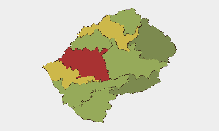
Maseru District (risk 78) and Mafeteng District (risk 65) drive the majority of in-country risk, reflecting capital-city concentrations of crime, gang activity, and inter-personal violence. Secondary risk hotspots include Leribe (62) and Berea (58), where winter weather vulnerability, informal settlement density, and limited law-enforcement presence compound baseline threats. Qacha's Nek (28) and Mokhotlong (38) show lower composite scores despite recent storm impacts, suggesting seasonal weather is not the primary risk driver in the formal threat model.
How GeoBit Would Assist
Security and duty-of-care teams with Lesotho operations should employ OSINT fusion and multi-language web/social monitoring (Intel Sweep, X/Telegram feeds, local media tracking) to detect emerging unrest, crime clusters, or border disruptions in real time. AOI (area-of-interest) monitoring with alerting on Maseru, Mafeteng, and key border crossings (Qacha's Nek, Ramatseliso's Gate, Van Rooyen's Gate) would provide early warning of renewed winter weather, road closures, or civil-order incidents. GIS and spatial analysis can be used to map safe routing and asset locations within the highest-risk districts and to model travel corridors around seasonal hazards.
7-Day Outlook
No acute escalation is expected in the next 7 days absent new weather systems or political shocks. Winter weather season (peaking July–August) is declining, reducing near-term road-closure and supply-chain risk. Routine political and judicial processes will continue; monitoring should remain passive but continuous, with focus on Maseru district and cross-border activity.
Highest-Risk Areas — Ranked
| # | State / Region | Risk |
|---|---|---|
| 1 | Maseru District | 78 |
| 2 | Mafeteng District | 65 |
| 3 | Leribe District | 62 |
| 4 | Berea District | 58 |
| 5 | Mohale's Hoek District | 52 |
| 6 | Butha-Buthe District | 48 |
| 7 | Thaba-Tseka District | 45 |
| 8 | Quthing District | 42 |
| 9 | Mokhotlong District | 38 |
| 10 | Qacha's Nek District | 28 |
Sources
Previous Daily Briefs
A new Lesotho brief is written every day — each with its own risk map and downloadable CSV. Here's the last week; use the calendar to go further back.
- August 15, 2026
- August 13, 2026
- August 11, 2026
- August 9, 2026
- August 7, 2026
- August 5, 2026
- August 4, 2026
📅 Browse every day by calendar →
Highlighted days have a brief. Tap a day for that day's map & analysis, or “csv” for that day's dataset ($5).
Atlas — our AI intelligence desk — emails them this snapshot personally. Nothing else, no list.