Situation Summary
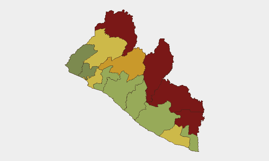
Liberia remains a low-threat environment globally (rank #151) with no significant security incidents recorded in the past week, but domestic political tensions have intensified around enforcement of a new cybercrime law and high-profile detentions. Eastern border counties—particularly Nimba, Lofa, and Grand Gedeh—carry substantially elevated risk scores (85–92) driven by historical cross-border trafficking, weak state presence, and organized-crime activity, though these remain latent rather than acute. The capital and commercial hub remain relatively stable, though recent court-ordered institutional closures and detention of political figures have triggered online dissent and renewed free-speech concerns. Overall trajectory is one of managed but fragile institutional coherence, with maritime and transnational threats acknowledged by senior government officials as a priority.
Key Developments
- Monrovia, September 23: Commercial Court ordered the National Oil Company of Liberia (NOCAL) and Ministry of Finance and Development Planning sealed and closed during sheriff-enforced proceedings in a debt case, signaling institutional strain and potential operational disruption to core government functions.
- National level, September 23: Former Foreign Minister Dee-Maxwell Saah Kemayah issued a public warning that declining public confidence and rising political mistrust could increase risk of demonstrations, clashes, and wider instability—a signals-level indicator of elite concern over social cohesion.
- Monrovia, September 24–25: Arrest of Jerry Nyantee Wrato on cybercrime charges (alleged cyberbullying of Vice-President Jeremiah Kpan Koung) triggered online protests and triggered press-freedom advocates' concerns that the cybercrime law is being applied to criminalize dissent; habeas-corpus hearing held in Monrovia.
- Monrovia Central Prison, September 24: Hundreds gathered as former President George Weah and opposition figures visited jailed former Vice-President Jewel Howard-Taylor; supporters chanted anti-government slogans and a brief scuffle was reported between Weah's security detail and police—the highest-profile show of opposition mobilization this week.
- National level, September 23–25: Dispute over the new cybercrime law's provisions on cyberbullying, false information, and offensive communications intensified between legal and political figures, with government defending it as addressing digital threats while critics warn of censorship risk.
- Gulf of Guinea maritime area, September 25: President Joseph Boakai identified transnational organized crime, cyber warfare, and illicit narcotics trafficking through maritime corridors as strategic threats and called for enhanced coast-guard surveillance and port-security technology at the United Nations.
Highest-Risk Areas
Nimba, Lofa, Grand Gedeh, and River Gee counties (risk scores 92, 88, 85, and 83 respectively) drive Liberia's sub-national threat landscape, reflecting their positions as porous border zones with Guinea and Côte d'Ivoire, weak government capacity, and historical nexus points for small-arms trafficking, drug transshipment, and cross-border banditry. Bong and Gbarpolu counties (72, 68) extend that risk corridor inland. These eastern and northern regions see minimal corporate or expatriate presence and carry elevated threat primarily from organized crime and statelessness rather than political violence; organizations with supply chains, mining interests, or staff movement in these zones should maintain enhanced due diligence. Montserrado (Monrovia, risk 64) remains the commercial and political focal point but benefits from stronger state presence and international scrutiny.
How GeoBit Would Assist
Security teams should deploy AOI Monitoring & Early Warning on Monrovia and sub-national flashpoints (prisons, courts, border crossings) to detect protest formation, detention escalation, or crowd gathering before operational impact. Intel Sweep and OSINT fusion (X/Twitter, Telegram, local media) would provide real-time sentiment tracking on the cybercrime law dispute and opposition mobilization to anticipate broader unrest. Maritime & Aviation tracking plus Network & Actor Analysis would support monitoring of Gulf of Guinea trafficking corridors and organized-crime networks active in Nimba and Lofa, informing supply-chain and travel-risk decisions.
7-Day Outlook
Near-term risk is likely to remain contained at the elite political-legal level, with cybercrime law enforcement and detention cases drawing opposition mobilization but no indication of sustained street violence or institutional breakdown. Monitor habeas-corpus outcomes and any further high-profile arrests as leading indicators of whether law enforcement is broadening beyond the Wrato case. Eastern border counties will remain chronic trafficking conduits; no acute event is forecast, but organizations dependent on those routes should expect persistent operational friction and criminal-network pressure.
Highest-Risk Areas — Ranked
| # | State / Region | Risk |
|---|---|---|
| 1 | Nimba County | 92 |
| 2 | Lofa County | 88 |
| 3 | Grand Gedeh County | 85 |
| 4 | River Gee County | 83 |
| 5 | Bong County | 72 |
| 6 | Gbarpolu County | 68 |
| 7 | Grand Kru County | 65 |
| 8 | Montserrado County | 64 |
| 9 | Rivercess County | 58 |
| 10 | Sinoe County | 55 |
| 11 | Margibi County | 52 |
| 12 | Grand Bassa County | 48 |
Sources
Previous Weekly Briefs
A new Liberia brief is written every Monday, covering the week — each with its own risk map and downloadable CSV. Use the calendar to go further back.
- September 22, 2026
- September 15, 2026
- September 8, 2026
- September 2, 2026
- August 31, 2026
- August 28, 2026
- August 26, 2026
📅 Browse past briefs by calendar →
Highlighted days have a brief. Tap a day for that day's map & analysis, or “csv” for that day's dataset ($5).
Atlas — our AI intelligence desk — emails them this snapshot personally. Nothing else, no list.