Situation Summary
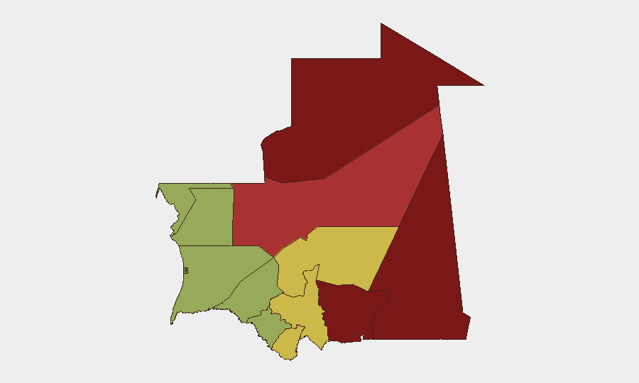
Mauritania remains a low-intensity, fragmented threat environment at the national level (composite score 7; #136 globally) with no active armed conflict or widespread civil unrest. Security incidents are predominantly localized: drug-trafficking enforcement, border-control incidents, and occasional traffic fatalities at police checkpoints. Risk is geographically concentrated in the eastern border regions—Tiris Zemmour, Hodh Ech Chargui, and Hodh El Gharbi—where weak state presence, cross-border trafficking, and potential transnational militant transit create persistent vulnerability.
Key Developments
- Néma (Hodh El Gharbi), 13 Aug 2026 – A police auxiliary principal died when a truck struck a control post on a main highway; two colleagues were injured. The vehicle was reportedly operated by ATTM, Mauritania's public-works and transport company. Circumstances remain unclear (mechanical failure vs. deliberate act).
- Néma (Hodh El Gharbi), 14 Aug 2026 – Several Mauritanian detainees were released by Malian authorities and arrived in Néma after transit from Côte d'Ivoire through Mali. The timing and context of their release warrant monitoring for potential human-trafficking or organized-crime signals.
- Atar (Adrar), 11 Aug 2026 – National Gendarmerie dismantled two drug-distribution networks, arresting 13 suspects and seizing cannabis resin and other controlled substances. This reflects ongoing enforcement capacity in the central Sahara.
Highest-Risk Areas
Tiris Zemmour (risk 95) and Hodh Ech Chargui (risk 85) dominate the national risk profile, followed by Hodh El Gharbi (80) and Adrar (78). This eastern tier—spanning the Mali, Algeria, and Western Sahara borders—experiences chronic illicit trafficking (narcotics, weapons, persons), limited government oversight, and seasonal nomadic-population movements that complicate law-enforcement and documentation. The recent incidents in Hodh El Gharbi and Adrar underscore that even nominally lower-risk regions remain vulnerable to sudden incidents and serve as transit zones for regional instability.
How GeoBit Would Assist
Security teams with personnel or supply chains in Mauritania should employ AOI Monitoring & Early Warning to track the eastern border regions and key highway checkpoints for emerging patterns (e.g., increased trafficking, control-post incidents, or cross-border militant movement). Intel Sweep and multi-language OSINT capabilities enable continuous tracking of Malian and Algerian spillover threats and drug-network activity. Routing & Network Analysis is critical for duty-of-care planning: it allows alternative journey planning that avoids high-risk checkpoints and identifies safer transit corridors, particularly for road movements through Adrar and Hodh El Gharbi.
7-Day Outlook
No major escalation is expected in the next seven days. Routine law-enforcement operations (drug busts, border control) will likely continue. However, the August 13 checkpoint fatality warrants brief elevated caution at major highway control posts in Hodh El Gharbi and southern Adrar; confirm real-time conditions before road movements through those areas. Monitor Malian cross-border developments (Mali unrest, terrorist activity near the border) as a leading indicator for downstream pressure on Mauritanian security.
Highest-Risk Areas — Ranked
| # | State / Region | Risk |
|---|---|---|
| 1 | Tiris Zemmour | 95 |
| 2 | Hodh Ech Chargui | 85 |
| 3 | Hodh El Gharbi | 80 |
| 4 | Adrar | 78 |
| 5 | Tagant | 68 |
| 6 | Guidimaka | 65 |
| 7 | Assaba | 62 |
| 8 | Gorgol | 58 |
| 9 | Trarza | 55 |
| 10 | Inchiri | 52 |
| 11 | Brakna | 48 |
| 12 | Dakhlet Nouadhibou | 45 |
Sources
Previous Daily Briefs
A new Mauritania brief is written every day — each with its own risk map and downloadable CSV. Here's the last week; use the calendar to go further back.
- August 12, 2026
- August 10, 2026
- August 8, 2026
- August 6, 2026
- August 5, 2026
- August 4, 2026
- August 3, 2026
📅 Browse every day by calendar →
Highlighted days have a brief. Tap a day for that day's map & analysis, or “csv” for that day's dataset ($5).
Atlas — our AI intelligence desk — emails them this snapshot personally. Nothing else, no list.