Situation Summary
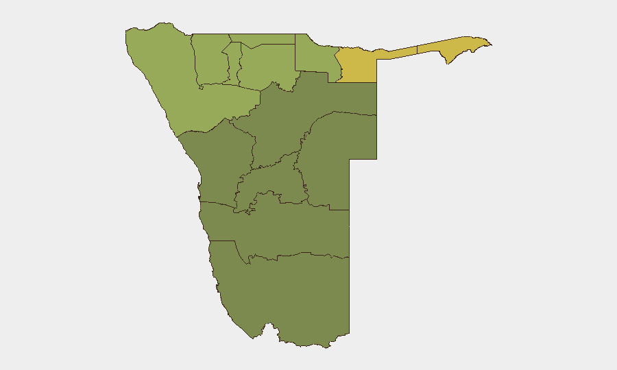
Namibia remains a low-threat environment globally (composite score 14) with no discrete security events in the current tracking window. Recent developments are largely localized and non-systemic: one serious violent crime in Windhoek, regulatory enforcement against informal liquor outlets, an alleged sexual assault at a hospital, and emerging governance/anti-corruption concerns. The northern regions—particularly Zambezi, Kavango East, and Kavango West—carry elevated composite risk scores (68, 62, 58 respectively), though current event data do not indicate acute instability in those areas.
Key Developments
- Windhoek, Katutura (Oshandumbala), 4 Aug 2026 (late evening): A 10-year-old boy was arrested for the alleged stabbing death of a 15-year-old following a domestic dispute; victim pronounced dead at Katutura Intermediate Hospital; murder case opened by police. This represents a serious but isolated violent incident in a known higher-crime township area.
- Oniipa, Oshikoto Region, 1 Aug 2026 (reported within last 48h): A 31-year-old male doctor was arrested at Onandjokwe District Hospital on suspicion of rape of a 26-year-old male patient in the doctor's consulting room; investigation ongoing.
- Gam settlement, Otjozondjupa Region, 4–5 Aug 2026: Police and local authorities closed more than ten unlicensed shebeens for liquor-licensing violations; enforcement action prompted complaints from operators and calls for regulatory clarity.
- Windhoek, Khomasdal (Ella du Plessis Secondary School), recent days (charges reported 4–5 Aug): A City of Windhoek legal adviser, Ngatatue Kandovazu, was charged with assault after allegedly striking a teacher on school premises.
- Nationwide, 4–5 Aug 2026 (governance/anti-corruption): Opposition party IPC publicly accused the government of failing to act on a completed Ernst & Young investigation into alleged fraud and theft at state-owned TransNamib rail operator, signalling governance-accountability concerns and potential reputational risk to state enterprises.
- Nationwide, 4–5 Aug 2026 (cybersecurity/governance): Home Affairs ministry emphasized that Namibia's planned digital ID roll-out will use domestic data hosting; civil-society and media discussion raised data-protection concerns, highlighting absence of robust privacy legislation and emerging cyber-risk appetite before e-ID deployment.
Highest-Risk Areas
Northern border regions drive the sub-national ranking: Zambezi (68), Kavango East (62), and Kavango West (58) reflect persistent cross-border mobility, informal trade networks, and historical governance-capacity constraints. Kunene Region (52) and Oshikoto (48) follow, correlating with remote terrain and lower state presence. Central and southern regions (Erongo, Hardap, Omaheke at 32–25) show significantly lower composite scores. Current event density does not yet show acute triggering incidents in the north, but the structural risk profile warrants heightened monitoring and contingency planning for any assets or personnel in those areas.
How GeoBit Would Assist
Security teams should deploy AOI Monitoring & Early Warning against high-risk northern regions (Zambezi, Kavango) for real-time alerting on cross-border movement, informal market disruption, or governance breakdowns. Intel Sweep and OSINT fusion (X/Twitter, Telegram, local media, sentiment analysis) will track governance narratives, anti-corruption developments, and emerging cyber-risk signals around the digital ID initiative. Alternative route/journey planning and Network & Actor Analysis support operational resilience should instability develop in border zones.
7-Day Outlook
No acute escalation is anticipated in the near term. Governance tensions around TransNamib and data-protection concerns are political/reputational rather than physical security threats. Vigilance should focus on township-level crime patterns in Windhoek and any signs of cross-border activity or administrative breakdown in the north; incidents currently remain sporadic and localized.
Highest-Risk Areas — Ranked
| # | State / Region | Risk |
|---|---|---|
| 1 | Zambezi | 68 |
| 2 | Kavango East | 62 |
| 3 | Kavango West | 58 |
| 4 | Kunene Region | 52 |
| 5 | Oshikoto | 48 |
| 6 | Ohangwena | 45 |
| 7 | Omusati | 42 |
| 8 | Oshana | 40 |
| 9 | Otjozondjupa | 35 |
| 10 | Erongo Region | 32 |
| 11 | Hardap | 28 |
| 12 | Omaheke | 25 |
Sources
Previous Daily Briefs
A new Namibia brief is written every day — each with its own risk map and downloadable CSV. Here's the last week; use the calendar to go further back.
📅 Browse every day by calendar →
Highlighted days have a brief. Tap a day for that day's map & analysis, or “csv” for that day's dataset ($5).
Atlas — our AI intelligence desk — emails them this snapshot personally. Nothing else, no list.