Situation Summary
Papua New Guinea remains a fragmented security environment with persistent tribal violence, gang activity, and localized armed conflict concentrated in the highlands. Over the past 72 hours, discrete incidents involving correctional services misconduct, tribal clashes, and gang-related violence have been documented, but no single event represents an escalation or systemic shift in the national threat picture. The composite national threat score (21/100) reflects the sub-national nature of risk: violence is geographically clustered rather than nationally coordinated, and international or transnational threats remain minimal.
Key Developments
- Enga Province — 2026-08-03: Three people killed in tribal violence between Makol and Makol Tap communities; Enga Provincial Police Commander issued public appeal for calm and warned of further escalation risk.
- Port Moresby area — 2026-08-04: Twenty Correctional Services personnel detained by police following incident involving disorderly conduct, illegal firearm discharge, and assault; circumstances and custody status remain under police investigation.
- Location unspecified, PNG — 2026-08-04: Armed robbery attempt by criminal gangs triggered community retaliation resulting in one gang member beaten to death and a second critically injured; suggests heightened neighborhood vigilante response in some urban/peri-urban areas.
Note on current incident density: Web research conducted over the preceding 24 hours identified no additional confirmed security incidents in Papua New Guinea within the last 48 hours beyond those listed above. Earlier June incidents (tribal killings in Enga, Goroka assault, Wewak homicide investigations) remain on police investigation dockets but fall outside the current reporting window.
Highest-Risk Areas
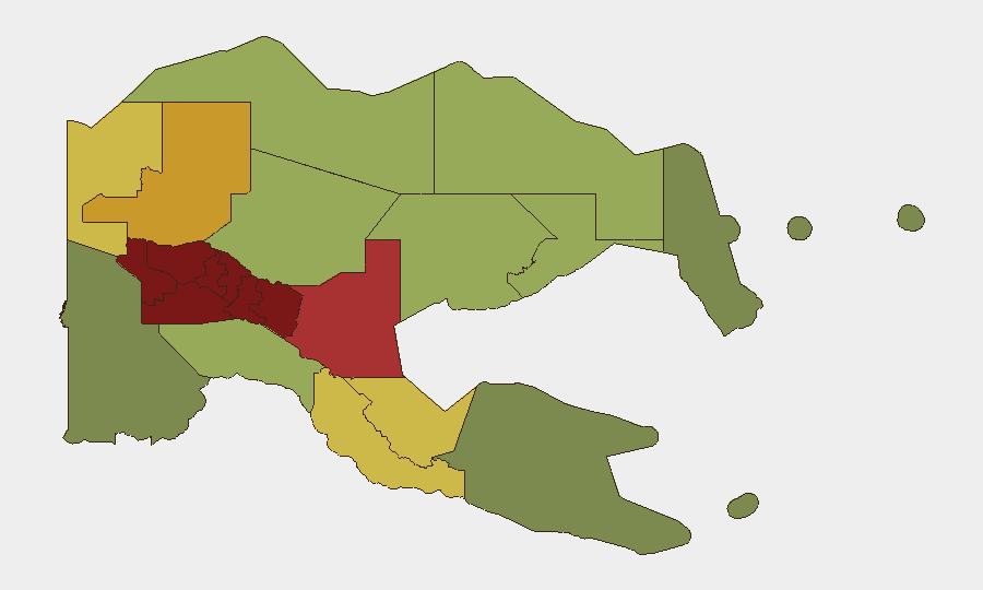
The Southern Highlands, Enga, Hela, Eastern Highlands, and Western Highlands provinces form a contiguous high-risk corridor (composite scores 90–98) driven by endemic tribal conflict, weak police presence, and proliferation of illegal firearms. Enga in particular has been the site of sustained police operations (Operation KUMUL 23, documented in June) targeting illegal weapons and violent offenders, indicating authorities recognize the severity. Port Moresby and the National Capital District rank seventh (risk 85), reflecting urban gang violence, armed robbery, and localized instability rather than organized conflict. Organizations with personnel or assets in the highlands should treat inter-community tensions as a chronic rather than acute risk, while Port Moresby-based operations face street-level crime and opportunistic armed assault.
How GeoBit Would Assist
GeoBit's AOI Monitoring & Early Warning capability, configured for high-risk provinces (particularly Enga, Southern Highlands, and NCD), enables persistent watch on emerging tribal mobilization, police operations, and gang activity with real-time alerting to duty-of-care teams. Multi-language OSINT feeds and X/Telegram intelligence tracking local police announcements, community radio, and community accounts provide granular context on localized violence and grievance escalation before media amplification. Routing & Network Analysis supports security teams planning safe transit corridors and alternative travel routes around active conflict zones, while Conflict & Military mapping clarifies the geographic and temporal pattern of incidents to inform site-hardening and personnel movement decisions.
7-Day Outlook
Tribal tensions in Enga and neighboring highlands provinces are expected to remain elevated, with police appeals for calm suggesting authorities anticipate further cycles of retaliation. Urban gang activity in Port Moresby will likely persist at current levels absent major law enforcement sweeps. No imminent national-level crisis or rapid geographic spread of violence is indicated by current signals.
Highest-Risk Areas — Ranked
| # | State / Region | Risk |
|---|---|---|
| 1 | Southern Highlands | 98 |
| 2 | Enga | 96 |
| 3 | Hela | 94 |
| 4 | Eastern Highlands | 92 |
| 5 | Western Highlands | 90 |
| 6 | Jiwaka | 88 |
| 7 | National Capital District | 85 |
| 8 | Simbu | 82 |
| 9 | Morobe | 78 |
| 10 | East Sepik | 72 |
| 11 | Sandaun | 68 |
| 12 | Oro | 66 |
Sources
Previous Daily Briefs
A new Papua New Guinea brief is written every day — each with its own risk map and downloadable CSV. Here's the last week; use the calendar to go further back.
📅 Browse every day by calendar →
Highlighted days have a brief. Tap a day for that day's map & analysis, or “csv” for that day's dataset ($5).
Atlas — our AI intelligence desk — emails them this snapshot personally. Nothing else, no list.