Situation Summary
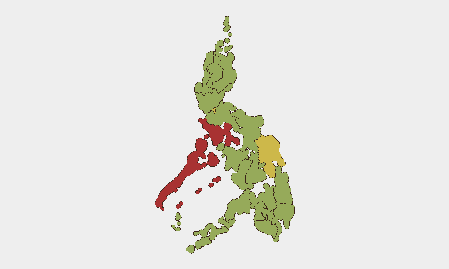
Philippines remains at moderate composite threat level (rank #29 globally, score 71/100) with 78 tracked events. The most recent signal cluster (June 23–25) indicates school-based armed confrontation, student-involved violence, arrest activity, and a US diplomatic statement, suggesting localized instability with potential interstate diplomatic dimension. The trajectory reflects persistent sub-national fragmentation rather than national destabilization, though several regions remain elevated-risk.
Key Developments
- School Armed Incident (June 23, location unconfirmed): Multiple small-arms combat signals between Philippine personnel, students, and school infrastructure, followed by physical assault, administrative sanctions, and arrest/detention activity. Nature and casualty count require verification via official PNP/AFP statements.
- US Diplomatic Response (June 25): Public statement from United States disapproving Philippine action or policy linked to the school incident cluster, signaling potential reputational or bilateral concern.
- Territory Occupation (June 23): Reported occupy-territory event involving Jewish-identified actors and Philippine state or assets; context and scale remain unclear and require corroboration.
- Public Threat Statements (June 23): Multiple public statements and threat-level declarations issued by Philippine authorities or public figures in connection with the school/student violence cluster.
Note on verification: GeoBit's event signals reflect indexed data; real-time confirmation of incident details, locations, casualty counts, and official response statements requires cross-check with Philippine National Police (PNP), Armed Forces of the Philippines (AFP), and credible news outlets (Inquirer, GMA News, ABS-CBN) publishing within the last 24–48 hours.
Highest-Risk Areas
Mimaropa (79.3) and Metro Manila (70.7) drive the composite risk ranking, together accounting for disproportionate event density. Mimaropa's elevation likely reflects maritime piracy, kidnap-for-ransom, or armed group activity in island-dispersed communities with weak state presence; Metro Manila concentrates political, infrastructure, and civilian-crowd risks including protest, electoral tension, and organized crime. Eastern Visayas (68.1) follows, indicating regional fragmentation across the central Philippines. Mindanao regions (Davao, Bangsamoro, Caraga, Northern Mindanao, Soccsksargen) cluster at 49–50, reflecting persistent low-intensity armed-group and criminal networks but not acute escalation signals at present.
How GeoBit Would Assist
Security teams with personnel or assets in Philippines should employ AOI Monitoring & Early Warning on Mimaropa, Metro Manila, and Eastern Visayas to receive automated alerts on armed confrontation, arrest/detention, and protest events within 2–4 hours of publication. Network & Actor Analysis on school-linked incidents and state security responses will identify whether violence reflects organized group activity, criminal enterprise, or isolated breakdown. Intel Sweep across PNP, AFP, and local-government-unit statements (via multi-language OSINT and Telegram/X monitoring) will confirm incident scope, official response, and protective measures in real time—essential for duty-of-care decisions on travel, site security, and personnel deployment.
7-Day Outlook
No signals presently indicate rapid national escalation. The June 23–25 cluster appears localized and reactive; if school incident is resolved through official investigation and arrest activity proceeds without secondary violence, risk should decline through early July. Monitor Mimaropa and Metro Manila for follow-on statements, court developments, or organized-group mobilization; any evidence of coordinated armed response or political weaponization would warrant 48-hour reassessment. Baseline elevated vigilance advised in Mimaropa (maritime/kidnap environment) and Metro Manila (density and symbolic targets) regardless of current headline.
Highest-Risk Areas — Ranked
| # | State / Region | Risk |
|---|---|---|
| 1 | Mimaropa | 79.3 |
| 2 | Metro Manila | 70.7 |
| 3 | Eastern Visayas | 68.1 |
| 4 | Negros Island Region | 50.2 |
| 5 | Davao Region | 49.6 |
| 6 | Cordillera Administrative Region | 49.6 |
| 7 | Bangsamoro | 49.3 |
| 8 | Caraga | 49.3 |
| 9 | Northern Mindanao | 49.3 |
| 10 | Soccsksargen | 49.3 |
| 11 | Ilocos Region | 49.3 |
| 12 | Cagayan Valley | 49.3 |
Sources
Previous Daily Briefs
A new Philippines brief is written every day — each with its own risk map and downloadable CSV. Here's the last week; use the calendar to go further back.
📅 Browse every day by calendar →
Highlighted days have a brief. Tap a day for that day's map & analysis, or “csv” for that day's dataset ($5).