Situation Summary
Serbia remains a low-threat environment globally (rank #95, composite score 19) with no tracked security incidents reported in the past seven days. However, underlying tensions tied to electoral activity and political competition continue to surface sporadically in Central Serbia, the country's highest-risk region. Recent weeks have seen isolated violence against civilians and activists, though the frequency and scale remain contained. The security picture is stable but requires continued monitoring through the election cycle.
Key Developments
- Ribarci border crossing, Serbia–Bulgaria border — 10 October: Serbian authorities denied entry to Bulgarian researcher Angel Dzhonev, citing "threat to national security." The grounds and context remain opaque and warrant further clarification from official sources.
- Subotica, Leskovac, and Vranje — 9 October: Multiple schools received bomb threats via email; Interior Ministry counter-sabotage teams conducted building searches. No explosives were reported found, and several threats were assessed as hoaxes. Evacuations proceeded as precaution.
- Background context (late September–early October): Three separate incidents involving violence against civilians were recorded in the week preceding this reporting period: a physical confrontation between SNS activists and Student List supporters over a banner (29 September); an attack on an Anti-Corruption Agency observer near an SNS campaign stand (1 October); and injury to a student activist by grass scythe during door-to-door canvassing, with competing narratives on provocation (3 October). These incidents reflect elevated political tension but remain isolated events rather than a sustained campaign.
Highest-Risk Areas
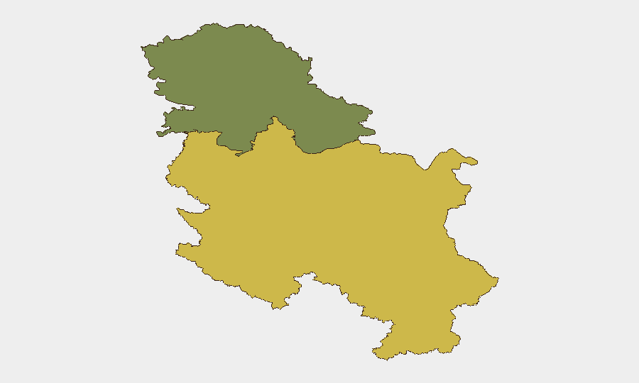
Central Serbia drives the composite risk profile at a score of 65, substantially above the national average and Vojvodina's score of 35. The concentration of recent violence against civilians—particularly incidents linked to electoral monitoring, student activism, and campaign activity—clusters in this region and reflects political competition intensity during the election period. Vojvodina, while notably lower-risk, remains on the watch list. Corporate and NGO personnel engaged in monitoring, advocacy, or campaign work in Central Serbia face the highest exposure to confrontation or harassment.
How GeoBit Would Assist
Security teams should deploy AOI Monitoring & Early Warning on Central Serbia's urban centers (Belgrade, Niš, Kragujevac) to track protest, rally, and campaign activity in near-real time, with alert triggers for violence keywords or escalation signals. OSINT fusion across X/Twitter, Telegram, and local media—combined with election monitoring capabilities—will provide advance visibility into planned political events, rival activist movements, and emerging tensions. Network & Actor Analysis can map relationships between SNS, Student List, Anti-Corruption Agency, and other key stakeholders to anticipate friction points and inform duty-of-care decisions for personnel in contested zones.
7-Day Outlook
No imminent spike in security incidents is signaled by available data. The school bomb threats appear isolated and likely hoax-related; investigation outcomes should clarify intent. Assuming the election cycle progresses without major triggering events, violence frequency is expected to remain low but sporadic confrontations between rival political and student groups will likely persist through the campaign period. Continued monitoring of Central Serbia's political calendar and activist movements is advisable to maintain early warning capability.
Highest-Risk Areas — Ranked
| # | State / Region | Risk |
|---|---|---|
| 1 | Central Serbia | 65 |
| 2 | Vojvodina | 35 |
Sources
Previous Weekly Briefs
A new Serbia brief is written every Monday, covering the week — each with its own risk map and downloadable CSV. Use the calendar to go further back.
- October 6, 2026
- September 29, 2026
- September 22, 2026
- September 15, 2026
- September 8, 2026
- September 2, 2026
- August 31, 2026
📅 Browse past briefs by calendar →
Highlighted days have a brief. Tap a day for that day's map & analysis, or “csv” for that day's dataset ($5).
Atlas — our AI intelligence desk — emails them this snapshot personally. Nothing else, no list.