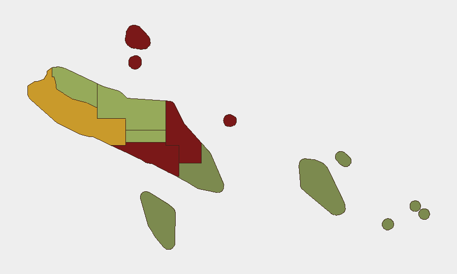
Situation Summary
Solomon Islands remains a low-threat environment globally (rank #147, composite threat score 7) with no corroborated major incidents of civil unrest, armed conflict, or large-scale crime reported in the last 24–48 hours. The country faces chronic governance and law-enforcement challenges concentrated in Honiara and surrounding provinces, but the current security posture shows no acute deterioration. A 5.3-magnitude offshore earthquake in Temotu Province on 24 August produced no reported casualties or infrastructure damage. Recent political and judicial developments reflect institutional activity rather than destabilizing events.
Key Developments
- Honiara – Opposition Shadow Ministerial Team (26 August 2026). Parliamentary opposition announced formation of a Shadow Ministerial Team to strengthen legislative scrutiny of government spending and policy. This is a political-process event with no immediate security implications.
- Honiara – High Court ruling on Pacific Games spending (26 August 2026). The Solomon Islands High Court found the National Hosting Authority acted without lawful authority in spending public funds on the 2023 Pacific Games. No associated protests or public unrest reported as of 26 August.
- Regional police cooperation agreement highlighted (25 August 2026). Vanuatu's Minister of Internal Affairs publicized a new Memorandum of Understanding between Vanuatu and Solomon Islands police on transnational crime (drugs, illegal fishing, people smuggling, cybercrime). This signals regional institutional cooperation; no incident or disturbance follows.
- Temotu Province earthquake (24 August 2026). A 5.3-magnitude earthquake at 10 km depth was recorded offshore Temotu Province. No tsunami warnings, casualties, or infrastructure failures confirmed.
- No acute unrest or conflict incidents reported (24–26 August 2026). Available open-source reporting confirms a low-incident security environment with routine law-enforcement activity and political process developments only.
Highest-Risk Areas
Honiara (risk 92) and Guadalcanal (risk 88) drive the country's threat profile, driven by gang activity, illicit-drug markets, and organized property crime. Malaita Province (risk 85) follows, reflecting similar organized-crime and inter-communal tension patterns. These three zones account for the majority of Solomon Islands' security incidents and represent the primary operational and duty-of-care concern for corporate assets and personnel. Western Province (risk 72) and Choiseul (risk 58) present moderate risk; eastern and southern provinces (Temotu, Rennell and Bellona) remain significantly lower-risk.
How GeoBit Would Assist
Security teams operating in Solomon Islands should employ AOI Monitoring & Early Warning on Honiara, Guadalcanal, and Malaita to detect escalations in gang activity, crime spikes, or political unrest with real-time alerting. Intel Sweep and X/Twitter OSINT capabilities enable continuous tracking of opposition movements, police operations, and community sentiment across provincial capitals. Routing & Network Analysis supports safer movement planning for personnel in high-risk urban zones, while multi-language search and sentiment analysis provide early indicators of political or social instability before they crystallize into unrest.
7-Day Outlook
No significant change in the current low-threat environment is anticipated. Governance tensions and court rulings may continue to occupy political space, but the absence of corroborated escalation or mass mobilization suggests institutional management of dissent. Routine crime and provincial gang activity will remain the primary operational security concern in Honiara and Guadalcanal.
Highest-Risk Areas — Ranked
| # | State / Region | Risk |
|---|---|---|
| 1 | Honiara | 92 |
| 2 | Guadalcanal | 88 |
| 3 | Malaita | 85 |
| 4 | Western | 72 |
| 5 | Choiseul | 58 |
| 6 | Isabel | 52 |
| 7 | Central Province | 48 |
| 8 | Makira-Ulawa | 38 |
| 9 | Rennell and Bellona | 22 |
| 10 | Temotu | 18 |
Sources
Previous Daily Briefs
A new Solomon Islands brief is written every day — each with its own risk map and downloadable CSV. Here's the last week; use the calendar to go further back.
- August 24, 2026
- August 22, 2026
- August 20, 2026
- August 18, 2026
- August 16, 2026
- August 14, 2026
- August 12, 2026
📅 Browse every day by calendar →
Highlighted days have a brief. Tap a day for that day's map & analysis, or “csv” for that day's dataset ($5).
Atlas — our AI intelligence desk — emails them this snapshot personally. Nothing else, no list.