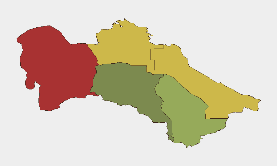
Situation Summary
Turkmenistan remains a low-transparency, tightly controlled environment with minimal public reporting of security incidents. No verifiable security, political-instability, crime, or infrastructure events have been documented in open sources for the past 24–48 hours; however, this absence of reporting reflects systemic constraints on independent journalism and civil disclosure rather than absence of underlying risk. The national composite threat score of 5 (ranked #162 globally) reflects the country's political stability at the state level, though significant regional variation persists. Overall trajectory remains stable under current governance conditions, with no indicators of imminent destabilization.
Key Developments
No discrete security, conflict, crime, political-unrest, or infrastructure incidents have been verifiably reported in Turkmenistan within the last 24–48 hours. Open-source intelligence collection (web search, social media, news feeds, and third-party reporting) has returned no credible, date-stamped incident reports for this timeframe. This is consistent with Turkmenistan's characterization as a data-poor operating environment due to restricted media freedom and limited international coverage, rather than an indicator of zero-risk conditions.
Analysts should note that operational security assessment in Turkmenistan typically depends on slower-moving consular advisories, NGO reporting, energy-sector infrastructure bulletins, and cross-border intelligence from neighboring states (Uzbekistan, Iran, Afghanistan) rather than real-time public incident feeds.
Highest-Risk Areas
The Balkan Region (risk 78) and Lebap Region (risk 68) drive the country's highest composite threat scores, substantially outpacing the capital and southern regions. Balkan's elevation reflects its geographic position as a transit corridor and energy-infrastructure hub; Lebap's risk profile is linked to proximity to the Aral Sea crisis zone and cross-border dynamics with Uzbekistan and Kazakhstan. By contrast, Ashgabat City (risk 18) and Ahal Region (risk 35) are assessed as significantly lower-risk, reflecting capital-based state control and relative geographic isolation. Organizations with personnel or assets in Balkan and Lebap should prioritize enhanced situational awareness and contingency planning; those in Ashgabat face lower operational friction.
How GeoBit Would Assist
Security teams operating in or monitoring Turkmenistan would use AOI Monitoring & Early Warning to establish persistent surveillance of Balkan and Lebap regions, alerting on emerging protests, border incidents, or infrastructure disruptions before they appear in mainstream reporting. OSINT Fusion & Corroboration (X/Twitter, Telegram, YouTube, and multi-language web search) provides continuous assessment of political statements, civil unrest indicators, and cross-border spillover from adjacent conflict zones in Afghanistan and the Caspian region. Routing & Network Analysis supports contingency planning for travel and supply-chain rerouting if regional instability escalates.
7-Day Outlook
No significant changes to the national security posture are anticipated in the near term. Regional risk (particularly in Balkan and Lebap) remains elevated relative to the capital but stable absent external shocks (e.g., major border incidents, energy-infrastructure failure, or spillover from Afghanistan). Duty-of-care teams should maintain standard monitoring protocols and ensure evacuation plans remain current for higher-risk regions.
Highest-Risk Areas — Ranked
| # | State / Region | Risk |
|---|---|---|
| 1 | Balkan Region | 78 |
| 2 | Lebap Region | 68 |
| 3 | Dashoguz Region | 62 |
| 4 | Mary Region | 42 |
| 5 | Ahal Region | 35 |
| 6 | Ashgabat City | 18 |
Sources
Previous Daily Briefs
A new Turkmenistan brief is written every day — each with its own risk map and downloadable CSV. Here's the last week; use the calendar to go further back.
📅 Browse every day by calendar →
Highlighted days have a brief. Tap a day for that day's map & analysis, or “csv” for that day's dataset ($5).
Atlas — our AI intelligence desk — emails them this snapshot personally. Nothing else, no list.