Situation Summary
Ukraine remains the seventh-highest-threat country globally, with 1,692 tracked security events as of 1 July 2026. Recent signals indicate sustained conventional military operations along multiple fronts, diplomatic tensions with Russia, and elevated threat to civilian infrastructure in major urban centers. The threat environment shows no signs of de-escalation; kinetic activity and cross-border military posturing continue at operational tempo.
Key Developments
- Dubna, Moscow Region (2026-06-30 to 2026-07-01): Ukrainian forces conducted a second strike on the Dubna satellite communications facility in Moscow region, according to statements by President Zelenskyy and corroborated by Sky News reporting. This represents a shift in targeting pattern toward Russian rear-area communications infrastructure.
- Kharkiv City, Kholodnohirskyi Raion (2026-06-29): Russian glide-bomb strikes killed at least one civilian and injured twelve others, with damage to civilian infrastructure reported. Kharkiv remains under sustained aerial pressure.
- Northern Border / Bryansk Sector (2026-06-30): Commander-in-Chief Oleksandr Syrskyi indicated Ukrainian intelligence assessments of a potential Russian offensive staging in Bryansk Oblast directed at northern Ukraine. This reflects heightened Russian activity in that sector but no imminent kinetic event as of reporting time.
- Conventional Military Operations (2026-06-29): Multiple signals confirm active Ukrainian military operations and counter-operations, including engagement with Russian forces. Specific unit designations (Yaroslavl) and geographic vectors remain under analysis.
- Diplomatic Escalation (2026-07-01): Ukraine issued a formal threat statement toward Russia, consistent with recent patterns of public warning and position-hardening on military and strategic matters.
- International Investigation (2026-06-30): Parisian authorities initiated an investigation into Ukrainian-related matters, suggesting international legal or diplomatic scrutiny of Ukrainian operations or actors—details remain limited.
Highest-Risk Areas
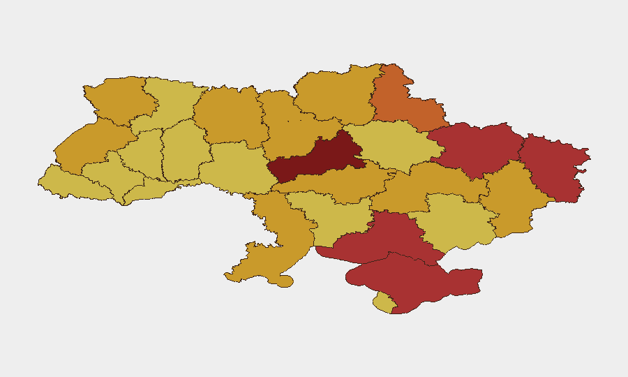
Kyiv (risk 100) and Cherkasy Oblast (89.9) dominate the risk profile, reflecting both capital-city concentration of national infrastructure and proximity to active military operations. The eastern and southern oblasts—Luhansk, Kherson, Kharkiv, and the Autonomous Republic of Crimea (all scoring 76–79)—sustain the highest physical threat from conventional military activity, aerial bombardment, and occupation-related instability. Mid-tier risk across Sumy, Chernihiv, Odesa, Dnipropetrovsk, Donetsk, and Kirovohrad oblasts (72–73) reflects distributed military engagement and civilian exposure across a wide geographic band. Risk is not concentrated but systemic across Ukraine's north, east, and south.
How GeoBit Would Assist
Security teams should deploy AOI Monitoring & Early Warning on corporate facilities and personnel locations in high-risk oblasts to track kinetic activity and receive real-time alerts. Conflict & Military battle mapping and force-structure tracking provide granular situational awareness of unit positions and operational tempo to inform movement decisions. Satellite & Imagery analysis combined with GIS & Spatial analysis enable assessment of infrastructure damage, route viability, and safe havens for personnel evacuation or shelter-in-place protocols.
7-Day Outlook
Conventional military operations are expected to continue at current intensity with no imminent ceasefire signals. Aerial bombardment of urban centers and critical infrastructure will remain a persistent threat to civilian populations and corporate assets in Kyiv, Kharkiv, and regional hubs. Border and rear-area targeting (as evidenced by the Dubna strike) may expand, increasing risk to supply chains and communications-dependent operations across broader geographic areas.
Highest-Risk Areas — Ranked
| # | State / Region | Risk |
|---|---|---|
| 1 | Kyiv | 100 |
| 2 | Cherkasy Oblast | 89.9 |
| 3 | Luhansk Oblast | 79.1 |
| 4 | Kherson Oblast | 79 |
| 5 | Kharkiv Oblast | 76.9 |
| 6 | Autonomous Republic of Crimea | 76.7 |
| 7 | Sumy Oblast | 73.1 |
| 8 | Chernihiv Oblast | 72.9 |
| 9 | Odesa Oblast | 72.5 |
| 10 | Dnipropetrovsk Oblast | 72.4 |
| 11 | Donetsk Oblast | 72.4 |
| 12 | Kirovohrad Oblast | 72.2 |
Sources
Previous Daily Briefs
A new Ukraine brief is written every day — each with its own risk map and downloadable CSV. Here's the last week; use the calendar to go further back.
📅 Browse every day by calendar →
Highlighted days have a brief. Tap a day for that day's map & analysis, or “csv” for that day's dataset ($5).