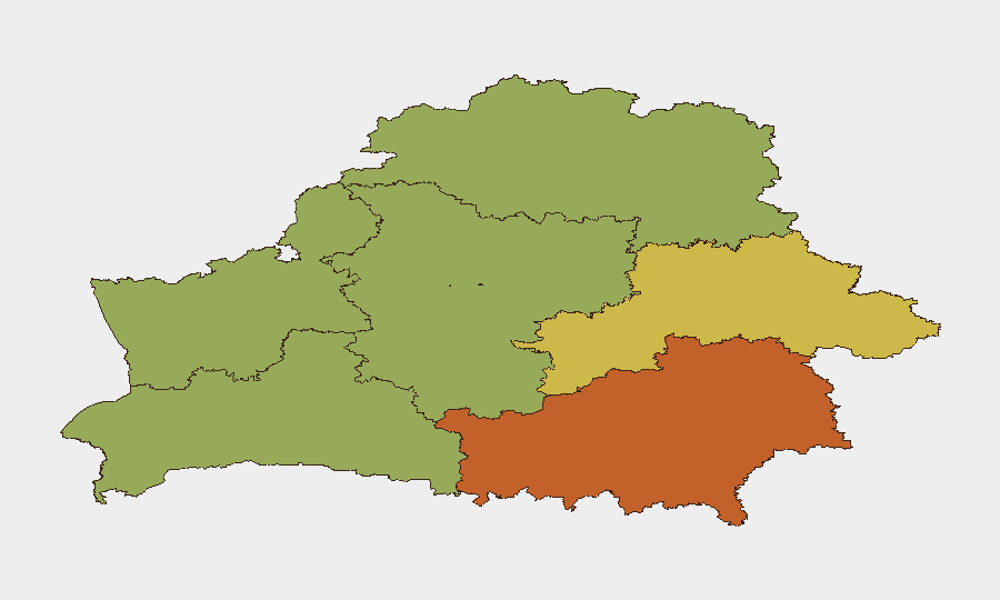
Situation Summary
Belarus remains a low–threat environment globally (rank #132, composite score 10) but presents localized and sector-specific risks concentrated in border regions and the capital. No major security incidents were recorded in the past 24–48 hours, but evolving developments—including Russian military use of Belarusian airspace, enhanced domestic surveillance measures, and elevated cyber-crime activity—warrant continued monitoring. The security posture reflects both external military transit risks and internal regulatory tightening, with greatest concern in Homyel Region and Minsk.
Key Developments
- Homyel Region airspace – Night of 31 August 2026 – A Russian combat drone transited Belarusian airspace near Tserukha, Rechytsa, Vasilevichy, and Naroulia, exiting toward Ukraine around 03:00. No strike in Belarus reported, but the event signals continued military use of Belarusian territory in Russia's Ukraine campaign.
- Belarus (nationwide) – 1 September 2026 – Interior Ministry reported over 400 telephone fraud complaints in a single 24-hour period, with 36 cyber-crimes recorded nationally. Police blocked 11 phishing websites, suspended 28 foreign payment requisites, and froze 57 bank accounts; two cash couriers were arrested with approximately 40,000 Belarusian rubles. This reflects elevated financial fraud and cyber-crime risk for residents and business transactions.
- Belarus (national rail system) – Reports dated 30–31 August 2026 – Opposition railway worker reports indicate a shortage of flatbed cars due to military allocation, coinciding with a joint Russian–Belarusian air-defense exercise (25 August–10 September). This signals ongoing military logistics activity via Belarus's infrastructure.
- All Belarusian schools – Effective 1 September 2026 – New government resolution permits police and private security to conduct selective searches of hand luggage at school entry points for all visitors and students, without parental presence required during minors' searches. This represents significant tightening of internal security procedures.
- Soligorsk District, Minsk Region – 1 September 2026 – Forest visiting restrictions expanded to 65 districts nationwide, with a complete ban in Soligorsk District. Enforcement and penalty risks apply to unauthorized entry.
- Brest Airport vicinity, Brest Region – 1 September 2026 – Aircraft spotters reported entering landing-approach zones, creating flight-safety risks. Authorities are escalating scrutiny of airport perimeter activity.
- Minsk and Brest (real-estate sector) – 1 September 2026 – Ministry of Justice suspended licenses of "Expert" agency (Minsk) and "Tvoy Dom" agency (Brest). License suspensions signal regulatory tightening relevant to property-market and foreign-investment risk.
Highest-Risk Areas
Homyel Region (risk 75) and Minsk (risk 68) drive the sub-national threat profile, reflecting proximity to the Ukrainian border and concentration of commercial/diplomatic activity respectively. Homyel's elevated score reflects both military transit exposure (demonstrated by the 31 August drone passage) and historical volatility along the Russia–Ukraine conflict corridor. Minsk's score reflects cyber-crime density, regulatory enforcement activity, and the capital's role as a commercial and administrative hub. Secondary concern areas—Mahilyow, Brest, and Hrodna Regions—all lie along or near Belarus's western and southern borders, maintaining persistent baseline risk from cross-border activity.
How GeoBit Would Assist
Security teams should employ AOI Monitoring & Early Warning to track Homyel Region airspace and border crossings for military transit recurrence, paired with OSINT fusion & corroboration of opposition and official sources to detect supply-chain disruptions (rail, freight) affecting operations. Network & Actor Analysis and cyber intelligence capabilities would provide early warning of fraud schemes, phishing campaigns, and financial-system targeting affecting employees and corporate assets. Routing & Network Analysis assists in flight-safety and ground-movement planning around airports and restricted zones.
7-Day Outlook
No major escalation of physical conflict or civil unrest is anticipated in the immediate term. Continued low-level military transit through Belarusian airspace toward Ukraine should be expected, with corresponding air-raid alerts affecting neighboring regions. Cyber-crime and financial fraud activity will likely remain elevated; regulatory enforcement and internal security measures (school searches, forest bans, license suspensions) are expected to continue as routine administrative policy.
Highest-Risk Areas — Ranked
| # | State / Region | Risk |
|---|---|---|
| 1 | Homyel Region | 75 |
| 2 | Minsk | 68 |
| 3 | Mahilyow Region | 62 |
| 4 | Brest Region | 55 |
| 5 | Hrodna Region | 52 |
| 6 | Minsk Region | 48 |
| 7 | Vitsebsk Region | 45 |
Sources
Previous Daily Briefs
A new Belarus brief is written every day — each with its own risk map and downloadable CSV. Here's the last week; use the calendar to go further back.
- August 30, 2026
- August 28, 2026
- August 26, 2026
- August 24, 2026
- August 22, 2026
- August 20, 2026
- August 18, 2026
📅 Browse every day by calendar →
Highlighted days have a brief. Tap a day for that day's map & analysis, or “csv” for that day's dataset ($5).
Atlas — our AI intelligence desk — emails them this snapshot personally. Nothing else, no list.