Situation Summary
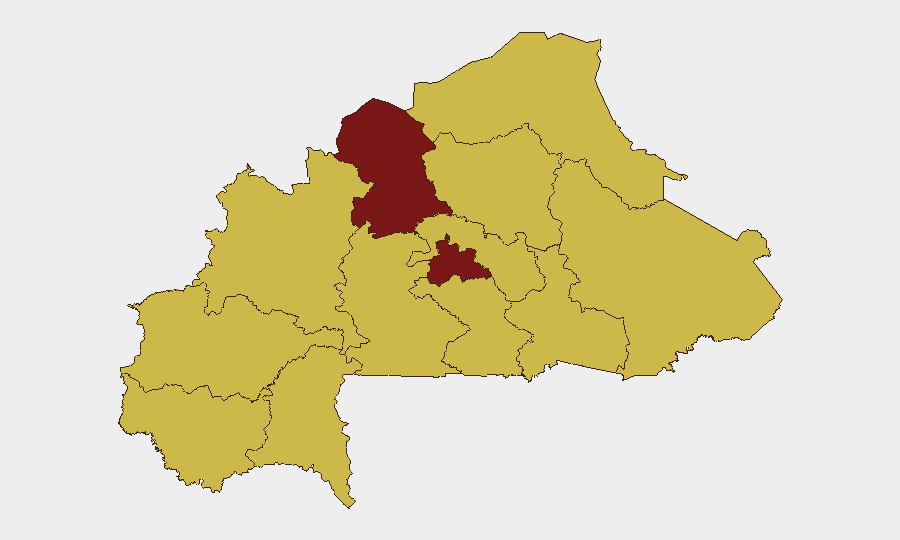
Burkina Faso remains the 15th highest-threat country globally (composite score 98/100) with 32 tracked security events. The North region dominates risk assessment (98.3), while the Centre is secondary (83.3); all other regions cluster at 68.3. Recent diplomatic friction—particularly EU–Burkina Faso tensions over internal governance (22 June) and bilateral Ghana–Burkina Faso border statements (22 June)—signals rising state-level fragility alongside persistent sub-state militant pressure concentrated in the North and Centre. The security trajectory remains volatile but contained to specific high-threat corridors.
Key Developments
- Ouagadougou — 22 June 2026 — Burkina Faso's foreign ministry summoned the EU representative and publicly rejected EU criticism of domestic governance, marking a fresh diplomatic rupture with a major economic and development partner.
- Burkina Faso–Ghana frontier — 22 June 2026 — Both governments issued public statements signaling renewed bilateral tension linked to border movement and cross-border security coordination; underlying operational triggers remain unconfirmed.
- Border sectors (nationwide) — 22–23 June 2026 — Expansion of border-surveillance infrastructure and deployment of modern surveillance towers reported, indicating active physical border hardening.
- National judicial apparatus — 24 June 2026 — Two detention/arrest events involving magistrate authority were recorded; specific locations and operational significance not yet clarified in available summaries.
- Ouagadougou and nationwide — 23–24 June 2026 — Rights-focused reporting highlighted continued pressure on journalists and civic actors, including reports of journalist disappearance; primarily human-rights concern rather than new tactical incident.
- Military positions (location unconfirmed) — 22–23 June 2026 — Social-media reports described attacks on Burkina Faso military installations, but no independent corroboration, precise locations, or casualty figures available; treat as preliminary signal only.
Highest-Risk Areas
The North region (98.3) is the dominant threat driver, reflecting sustained militant activity and minimal state administrative reach. The Centre (83.3) remains the secondary flashpoint, likely reflecting both spillover from the North and urban pressure-point vulnerabilities in and around Ouagadougou. The remaining ten regions, clustered at 68.3, indicate either lower-intensity insurgent activity or reduced reporting density; however, the uniformity of that score suggests data-collection gaps rather than genuine parity of risk. Border zones and the Sahel corridor warrant continuous monitoring given recent diplomatic friction and surveillance-infrastructure deployments.
How GeoBit Would Assist
Security teams should deploy AOI Monitoring & Early Warning on the North region and Centre—particularly Ouagadougou, border crossings, and key military installations—to catch tactical escalation before it propagates. Conflict & Military force-structure and weapons-capability tracking, combined with Intel Sweep and X/Twitter & Telegram OSINT, will detect militant operational tempo and cross-border support flows. Routing & Network Analysis supports alternative journey planning for personnel transiting high-risk areas, while GIS & Spatial Analysis and satellite monitoring can validate border-hardening activities and flag new checkpoint or access restrictions.
7-Day Outlook
Diplomatic tension with the EU and Ghana is unlikely to produce immediate security de-escalation; expect continued public positioning and possible further restrictions on international engagement. Militant activity in the North and Centre will likely persist at current operational tempo. Border-surveillance expansion may tighten movement corridors and increase detention risk at crossing points; personnel and supply-chain routing should be reviewed for contingency.
Highest-Risk Areas — Ranked
| # | State / Region | Risk |
|---|---|---|
| 1 | North | 98.3 |
| 2 | Centre | 83.3 |
| 3 | Upper-Basins | 68.3 |
| 4 | Boucle du Mouhoun | 68.3 |
| 5 | Central-West | 68.3 |
| 6 | Central-South | 68.3 |
| 7 | Central-East | 68.3 |
| 8 | Waterfalls | 68.3 |
| 9 | Southwest | 68.3 |
| 10 | Sahel | 68.3 |
| 11 | Central-North | 68.3 |
| 12 | East | 68.3 |
Sources
Previous Daily Briefs
A new Burkina Faso brief is written every day — each with its own risk map and downloadable CSV. Here's the last week; use the calendar to go further back.
📅 Browse every day by calendar →
Highlighted days have a brief. Tap a day for that day's map & analysis, or “csv” for that day's dataset ($5).