Situation Summary
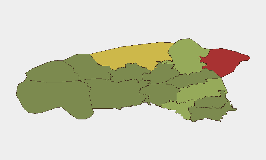
Estonia remains a low-threat environment globally (composite score 2; no tracked discrete events in the current reporting window), but sub-national risk concentration in the north—particularly Ida-Viru County (risk 78)—reflects ongoing proximity to Russian territory, cross-border infrastructure vulnerabilities, and periodic airspace incursions. Recent weather-related infrastructure disruptions (power loss in Hiiumaa) and border-security policy shifts underscore the operational fragility of critical systems in peripheral regions. The threat trajectory is stable but contingent on maintaining border vigilance and infrastructure resilience.
Key Developments
- Hiiumaa Island – Late July 2026 – Severe thunderstorms caused widespread power outages across the island, disrupting critical infrastructure and communications; restoration status remains unclear.
- Põltsamaa / Tallinn–Tartu Road (110 km mark) – Late July 2026 – A multi-vehicle collision caused significant traffic paralysis on Estonia's primary north–south transport corridor; incident highlights vulnerability of key road networks to both human error and cascading delays.
- Narva-1, Koidula & Luhamaa Border Checkpoints – 28 July 2026 – Estonia's Interior Ministry proposed making 12-hour operating windows permanent; stated rationale was border-security and customs control strengthening, though border-crossing volume has declined.
- Police Operations (nationwide) – Late July 2026 – Estonian police reported a spike in calls related to potential bomb threats; specifics on locations, verification status, or response outcomes are not yet public.
- South Estonia Airspace & Border – 22 June 2026 (background context: part of ongoing pattern since May) – An attack drone carrying 5 kg of explosives was recovered; authorities assessed it likely originated from Ukraine as a strike on Russian targets. Combined with a confirmed UAV incursion detected by Estonian Defence Forces on 19 May, this reflects continued risk of unmanned systems entering Estonian airspace from the Russian–Ukrainian theatre.
Highest-Risk Areas
Ida-Viru County (78) and Harju County (68) drive the national risk profile, both concentrated in the northeast and northwest respectively. Ida-Viru's elevated score reflects its direct adjacency to the Russian border, infrastructure density in Narva, and documented airspace and border-crossing activity. Harju, encompassing Tallinn and the capital's port and logistics hub, faces dual exposure: critical national infrastructure concentration and transit-route vulnerability. Tartu County (58) ranks third, reflecting road-network centrality and population density. Southern and western counties show markedly lower risk, suggesting threat concentration correlates directly with Russian proximity and critical asset density.
How GeoBit Would Assist
Corporate security teams should deploy AOI Monitoring & Early Warning on Ida-Viru and Harju counties to detect border-crossing anomalies, airspace incursions, and infrastructure disruptions in real time. Intel Sweep (OSINT fusion, multi-language Telegram/X monitoring, and radio SIGINT) would provide 24-hour visibility into police operations, border policy changes, and cross-border actor movement. Routing & Network Analysis capabilities enable alternative journey planning around the Tallinn–Tartu corridor and border checkpoints, reducing exposure to traffic and congestion during high-risk windows.
7-Day Outlook
Border-security posture will likely remain elevated following the permanent checkpoint-window proposal; no immediate escalation expected. Weather-related infrastructure disruptions in peripheral regions (Hiiumaa model) remain seasonal risk. Airspace incursions and bomb-threat reporting volumes should be monitored for trend shifts indicating shifts in broader regional tensions; no near-term de-escalation signals visible.
Highest-Risk Areas — Ranked
| # | State / Region | Risk |
|---|---|---|
| 1 | Ida-Viru County | 78 |
| 2 | Harju County | 68 |
| 3 | Tartu County | 58 |
| 4 | Valga County | 55 |
| 5 | Lääne-Viru County | 52 |
| 6 | Pärnu County | 35 |
| 7 | Rapla County | 32 |
| 8 | Jõgeva County | 30 |
| 9 | Järva County | 28 |
| 10 | Viljandi County | 25 |
| 11 | Põlva County | 22 |
| 12 | Võru County | 18 |
Sources
Previous Daily Briefs
A new Estonia brief is written every day — each with its own risk map and downloadable CSV. Here's the last week; use the calendar to go further back.
📅 Browse every day by calendar →
Highlighted days have a brief. Tap a day for that day's map & analysis, or “csv” for that day's dataset ($5).
Atlas — our AI intelligence desk — emails them this snapshot personally. Nothing else, no list.