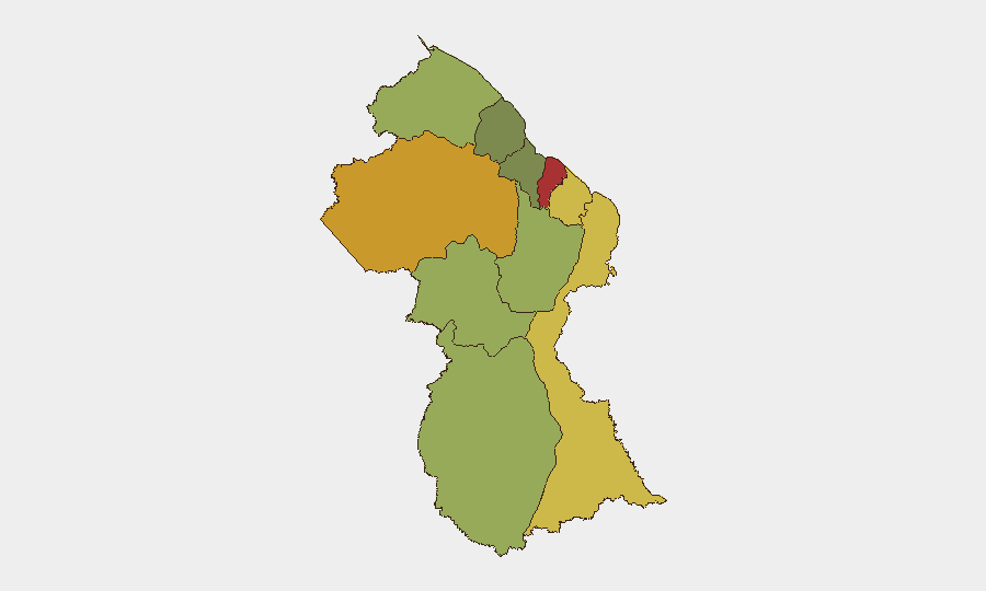
Situation Summary
Guyana remains a moderate-risk environment (global rank #66, composite threat score 18) with concentrated vulnerabilities in its coastal regions and interior mining zones. The country's security posture is shaped by resource-driven crime, transnational trafficking networks, and jurisdictional disputes that span from maritime boundaries to inland territories. Recent diplomatic signals (noted in 24-hour event feeds) suggest ongoing U.S.–Guyana friction, though the operational security impact on the ground remains unconfirmed at present. The trajectory is stable but fragile, dependent on enforcement capacity and regional actor behavior.
Key Developments
- 2026-07-12 · Public Statement · GUYANA – A statement from Guyana's government was issued on 12 July; specific content and operational significance require source verification and cannot be confirmed from available open feeds at this time.
- 2026-07-11 · Public Statement · UNITED STATES vs GUYANA – A diplomatic communication was logged on 11 July; the nature of the dispute (trade, security, maritime, or other) is not yet clarified in available reporting.
- 2026-07-11 · Arrest/Detain · MAGISTRATE vs UNITED STATES – A detention or legal action involving a U.S. national was recorded on 11 July; details (location, charge, individual identity) are pending confirmation.
Note: No verified, time-sensitive security incidents (crime, unrest, infrastructure failure, or trafficking event) could be confirmed in the 24–48-hour window from available open-source research. Diplomatic and legal events are noted but lack operational context for direct asset or personnel risk assessment.
Highest-Risk Areas
Demerara-Mahaica (risk 78) and Cuyuni-Mazaruni (risk 72) dominate the threat landscape. Demerara-Mahaica, which includes Georgetown and the primary commercial corridor, faces drug-trafficking competition, gang activity, and smuggling networks that exploit port and border infrastructure. Cuyuni-Mazaruni, an interior mining region bordering Venezuela, is a nexus for illegal gold extraction, armed group presence, and trafficking of persons and weapons. Mahaica-Berbice (risk 65) and East Berbice-Corentyne (risk 62) follow, with similar drivers—remote locations, porous borders, and limited law-enforcement reach. The interior and eastern regions (Potaro-Siparuni through Essequibo Islands, risk 48–35) present lower but persistent risks tied to resource extraction and maritime crime.
How GeoBit Would Assist
Intel Sweep and OSINT Fusion would triangulate the 11–12 July diplomatic and legal signals with local reporting, Telegram networks, and social media sentiment to determine whether the U.S.–Guyana friction signals broader enforcement actions or asset-seizures affecting corporate operations. AOI Monitoring & Early Warning on Demerara-Mahaica and Cuyuni-Mazaruni would provide persistent alerting for trafficking incidents, gang violence escalations, or border security shifts that could delay logistics or restrict travel. Network & Actor Analysis would map trafficking and smuggling organizations operating in high-risk zones to inform personnel routing, supply-chain resilience, and liaison protocols with local authorities.
7-Day Outlook
No major security deterioration is forecast in the immediate term, but the recent diplomatic activity and legal action merit close monitoring. Resource-sector operations (particularly mining and hydrocarbon) remain vulnerable to supply-chain disruption, border friction, and transnational criminal pressure. Corporate security teams should refresh situational awareness through multi-source feeds and stress-test evacuation and contingency protocols for their highest-risk locations.
Highest-Risk Areas — Ranked
| # | State / Region | Risk |
|---|---|---|
| 1 | Demerara-Mahaica | 78 |
| 2 | Cuyuni-Mazaruni | 72 |
| 3 | Mahaica-Berbice | 65 |
| 4 | East Berbice-Corentyne | 62 |
| 5 | Upper Demerara-Berbice | 58 |
| 6 | Potaro-Siparuni | 48 |
| 7 | Barima-Waini | 45 |
| 8 | Upper Takutu-Upper Essequibo | 42 |
| 9 | Pomeroon-Supenaam | 38 |
| 10 | Essequibo Islands | 35 |
Sources
Previous Daily Briefs
A new Guyana brief is written every day — each with its own risk map and downloadable CSV. Here's the last week; use the calendar to go further back.
📅 Browse every day by calendar →
Highlighted days have a brief. Tap a day for that day's map & analysis, or “csv” for that day's dataset ($5).
Atlas — our AI intelligence desk — emails them this snapshot personally. Nothing else, no list.