Situation Summary
Ivory Coast remains a low-to-moderate security concern globally (rank #68, composite threat score 25), with civil unrest as the primary driver. No confirmed security incidents have been verified in the last 24–48 hours; the most recent corroborated event is intercommunal violence in Kossandji (Alépé district) on 2026-08-05, which resulted in at least 3 deaths and multiple injuries. Northern and northeastern districts continue to pose elevated risk due to proximity to Mali and Burkina Faso border instability, though activity remains below critical thresholds. The overall trajectory is stable but fragile, with latent terrorism risk and communal tensions requiring sustained monitoring.
Key Developments
- No confirmed incidents in last 24–48 hours. Web research and monitored sources have not surfaced corroborated security events, crime spikes, infrastructure disruption, or political instability within the reporting window (2026-08-07 to 2026-08-09).
- Kossandji intercommunal violence (2026-08-05, outside current window). Violent clashes between autochthonous Akyé youth and allochthonous Mossi and Lobi communities in Alépé district (Gôh-Djiboua region) resulted in at least 3 deaths, multiple injuries, and damage to property. This remains the most recent verified incident and underscores ongoing communal tension in southern-central regions.
- Unverified militant-camp claim near Tingréla. A single social-media post claims discovery of a major militant camp in Tingréla (Savanes district) but lacks independent corroboration. This should not be treated as confirmed until validated by a second credible source.
- Static border-terrorism context. German and other international travel advisories maintain warnings against non-essential travel in Mali and Burkina Faso border zones due to latent terrorism risk and armed-group activity, with potential spillover into northern Ivory Coast. No new border incident has been confirmed in the last 48 hours.
Highest-Risk Areas
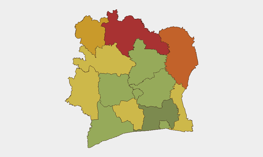
Savanes, Zanzan, Denguélé, and Comoé districts (composite risk scores 78–70) drive the country's elevated subnational threat profile, all located in the north and northeast along the Mali–Burkina Faso frontier. Risk in these zones stems primarily from armed-group presence in neighboring countries, cross-border militant activity, and weak state control. Montagnes district (risk 68) and Woroba district (risk 65) extend this band westward, reflecting porous borders and limited security-force density. Gôh-Djiboua and Sassandra-Marahoué districts (risk 60 and 58) show elevated communal-violence risk, as evidenced by the Kossandji incident; Abidjan (risk 45) remains the lowest-risk major center but warrants standard urban-crime vigilance.
How GeoBit Would Assist
Security teams should use AOI Monitoring & Early Warning on the northern border districts (Savanes, Zanzan, Denguélé, Comoé) and Gôh-Djiboua to detect emerging communal tensions or cross-border militant incursions in near-real time. Intel Sweep and multi-language OSINT fusion across local and regional sources would verify unconfirmed claims (e.g., Tingréla) and surface intercommunal disputes before they escalate. Routing & Network Analysis supports duty-of-care planning for personnel in or transiting high-risk districts by identifying alternative routes and safe zones.
7-Day Outlook
No significant escalation is anticipated in the next seven days based on current intelligence and trend analysis. Communal tensions in the south-center and cross-border dynamics in the north remain the primary vectors for disruption; continued monitoring of intercommunal flashpoints (Alépé, Gôh-Djiboua) and border-adjacent districts is warranted. Staff movement and asset exposure in northern districts should remain subject to heightened access controls and real-time situational awareness.
Highest-Risk Areas — Ranked
| # | State / Region | Risk |
|---|---|---|
| 1 | Savanes District | 78 |
| 2 | Zanzan District | 75 |
| 3 | Denguélé District | 72 |
| 4 | Comoé District | 70 |
| 5 | Montagnes District | 68 |
| 6 | Woroba District | 65 |
| 7 | Gôh-Djiboua District | 60 |
| 8 | Sassandra-Marahoué District | 58 |
| 9 | Vallée du Bandama District | 55 |
| 10 | Bas-Sassandra District | 52 |
| 11 | Lacs District | 48 |
| 12 | Abidjan | 45 |
Sources
Previous Daily Briefs
A new Ivory Coast brief is written every day — each with its own risk map and downloadable CSV. Here's the last week; use the calendar to go further back.
📅 Browse every day by calendar →
Highlighted days have a brief. Tap a day for that day's map & analysis, or “csv” for that day's dataset ($5).
Atlas — our AI intelligence desk — emails them this snapshot personally. Nothing else, no list.