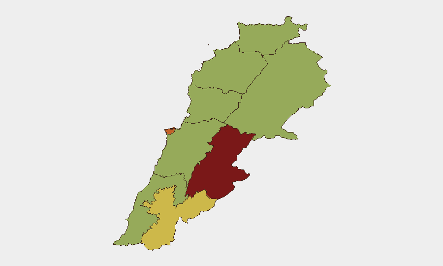
Situation Summary
Lebanon is experiencing a sharp escalation in cross-border military operations following a breakdown in ceasefire frameworks between Israeli forces and Hezbollah-affiliated units. Over the past 24–48 hours, approximately 80 Israeli airstrikes have struck southern Lebanon and parts of the Beqaa Valley, resulting in at least 28 confirmed deaths and 139 wounded, alongside reported ground operations involving home demolitions and new checkpoints in occupied southern areas. The Beqaa Governorate (risk score 83.9) and Beirut Governorate (74.7) remain the highest-risk zones, while southern border towns in Nabatieh Governorate (66) face active kinetic operations. The situation shows no signs of de-escalation, with both Israeli military claims of anti-Hezbollah strikes and Lebanese civilian casualty reports suggesting sustained operational intensity.
Key Developments
- Nabatieh al-Fawqa, Nabatieh Governorate (13 July, 2026): Israeli airstrike killed four civilians; described as ceasefire violation by Lebanese health and media sources.
- Hadata/Haddatha security zone, South Lebanon (13–14 July, 2026): Israeli forces reported establishing operational control and destroying over 90 Hezbollah-linked infrastructure sites; Lebanese outlets simultaneously reported house detonations, fires, and massive explosions in nearby Bint Jbeil.
- Mansouri and Houla towns, South Lebanon (14 July, 2026): Two Israeli air raids with four missiles struck Mansouri; additional bombing operations reported around Houla, with fresh casualties documented.
- Nabatieh–Kfartebnit region, Nabatieh Governorate (14 July, early hours): Israeli artillery shelling reported in dawn operations following overnight explosions in Bint Jbeil; no detailed casualty figures released.
- Qabrikha and Ali al-Taher hill area, South Lebanon (13 July, 2026): Israeli artillery and drone strikes reported; no immediate casualties confirmed but both described as ceasefire breaches by Lebanese and regional outlets.
- Aqidah area, South Lebanon (13 July, 2026): Israeli military stated it struck a Hezbollah cell; Lebanese security briefs recorded the incident as part of the ongoing 24-hour escalation cycle.
- Countrywide southern border belt and Beqaa Valley (13–14 July, rolling 24 hours): Approximately 80 Israeli airstrikes documented; at least 28 deaths and 139 wounded reported alongside ground operations including home demolitions and checkpoint establishment in occupied southern areas.
Highest-Risk Areas
The Beqaa Governorate (83.9) drives the composite risk ranking due to documented Iranian military mobilization, small-arms combat involving the Lebanese Army, and Shiite faction tensions—all recorded in the past 72 hours. Beirut Governorate (74.7) ranks second, reflecting public statements of disapproval toward Israel and rejection of ceasefire frameworks by Shiite political actors, alongside criminal unconventional violence. Nabatieh Governorate (66) faces the most active kinetic threat, with confirmed Israeli airstrikes, artillery shelling, and ground operations in multiple towns over the past 24 hours. Mount Lebanon, North, Akkar, South, and Baalbek-Hermel Governorates (all 53.9) are secondary concern zones but remain stable relative to the top three.
How GeoBit Would Assist
Security teams with personnel or assets in Lebanon should prioritize AOI Monitoring & Early Warning for Beqaa and Beirut Governorates to detect military mobilization and political statements signaling further escalation, paired with Battle Mapping and Force Structure tracking to monitor Israeli and Hezbollah operational deployments. Satellite & Imagery Analysis and GIS & Spatial Analysis enable real-time identification of newly occupied zones, checkpoints, and infrastructure damage in southern border areas, informing evacuation and movement decisions. Intel Sweep and multi-language OSINT Fusion corroborate Lebanese, Israeli, and international casualty and operational claims, reducing misinformation exposure during high-stress decision-making.
7-Day Outlook
Sustained Israeli air and ground operations are expected to continue through at least mid-week, with Nabatieh and southern border zones remaining primary targets. Hezbollah and Iranian-backed militia responses are probable, potentially expanding kinetic activity into the Beqaa Valley and triggering secondary strikes on Beirut infrastructure or civilian areas. De-escalation prospects remain low absent international diplomatic intervention; corporate duty-of-care teams should assume 7–14 day operational continuity of current threat levels.
Highest-Risk Areas — Ranked
| # | State / Region | Risk |
|---|---|---|
| 1 | Beqaa Governorate | 83.9 |
| 2 | Beirut Governorate | 74.7 |
| 3 | Nabatieh Governorate | 66 |
| 4 | Keserwan-Jbeil Governorate | 54.2 |
| 5 | North Governorate | 53.9 |
| 6 | Akkar Governorate | 53.9 |
| 7 | Mount Lebanon Governorate | 53.9 |
| 8 | South Governorate | 53.9 |
| 9 | Baalbek-Hermel Governorate | 53.9 |
Sources
Previous Daily Briefs
A new Lebanon brief is written every day — each with its own risk map and downloadable CSV. Here's the last week; use the calendar to go further back.
📅 Browse every day by calendar →
Highlighted days have a brief. Tap a day for that day's map & analysis, or “csv” for that day's dataset ($5).
Atlas — our AI intelligence desk — emails them this snapshot personally. Nothing else, no list.