Situation Summary
Lesotho remains at low acute risk (global rank #153, composite threat score 6) with no verified security incidents, civil unrest, or infrastructure disruptions reported in open sources for 21–22 August 2026. The security environment is stable relative to regional comparators, though underlying vulnerabilities in governance, informal-sector crime, and cross-border smuggling persist. No travel restrictions or significant operational disruptions affecting corporate personnel or assets are indicated at present.
Key Developments
No discrete security incidents, protests, armed clashes, or major crime events affecting travel or operations in Lesotho were confirmed in open-source reporting for the last 24–48 hours (21–22 August 2026). While this absence of reported activity indicates relative stability, it does not preclude lower-level criminality or local disturbances below the threshold of global media coverage. Organizations with personnel or assets in Lesotho should note that absence of reporting does not equal zero risk; localized incidents in rural or peripheral districts may not surface in international feeds.
Highest-Risk Areas
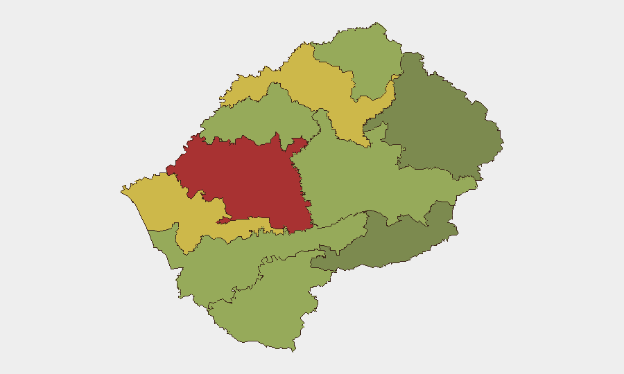
Maseru District (risk 78) dominates the country's threat landscape, driven by concentration of commercial activity, cross-border transit through South Africa, informal-sector crime, and administrative friction. Mafeteng (65), Leribe (62), and Berea (58) districts show elevated composite scores, likely reflecting secondary urban centers, smuggling corridors, and inter-communal tensions. Southern and eastern districts (Qacha's Nek, Mokhotlong) register lower indices, suggesting less organized crime and fewer major population nodes. Organizations operating in or transiting Maseru should apply heightened duty-of-care protocols; rural postings in Thaba-Tseka, Butha-Buthe, and Mokhotlong carry different exposure (isolation, limited emergency services) rather than acute violence risk.
How GeoBit Would Assist
Security teams should employ AOI Monitoring & Early Warning on Maseru District and secondary urban centers to detect protests, roadblocks, or crime spikes in real time. Multi-language OSINT (Sesotho and English social media, local news aggregation) and X/Twitter & Telegram OSINT will flag emerging incidents faster than international wires. Routing & Network Analysis can identify alternative travel routes and transit corridors if primary roads or border crossings become congested or unsafe. For longer-term resilience, Risk & Threat Assessment and Network & Actor Analysis help map informal power structures and smuggling networks that may affect supply chains or staff movement.
7-Day Outlook
No acute developments are forecast for the coming week absent new political or economic shocks. Seasonal cross-border traffic and informal trade will continue; monitoring for any disruptions to road access toward South Africa remains standard practice. Organizations should maintain baseline duty-of-care posture for Maseru and transit corridors while treating peripheral districts as lower-priority for acute-incident planning.
Highest-Risk Areas — Ranked
| # | State / Region | Risk |
|---|---|---|
| 1 | Maseru District | 78 |
| 2 | Mafeteng District | 65 |
| 3 | Leribe District | 62 |
| 4 | Berea District | 58 |
| 5 | Mohale's Hoek District | 52 |
| 6 | Butha-Buthe District | 48 |
| 7 | Thaba-Tseka District | 45 |
| 8 | Quthing District | 42 |
| 9 | Mokhotlong District | 38 |
| 10 | Qacha's Nek District | 28 |
Sources
Previous Daily Briefs
A new Lesotho brief is written every day — each with its own risk map and downloadable CSV. Here's the last week; use the calendar to go further back.
- August 20, 2026
- August 18, 2026
- August 15, 2026
- August 13, 2026
- August 11, 2026
- August 9, 2026
- August 7, 2026
📅 Browse every day by calendar →
Highlighted days have a brief. Tap a day for that day's map & analysis, or “csv” for that day's dataset ($5).
Atlas — our AI intelligence desk — emails them this snapshot personally. Nothing else, no list.