Situation Summary
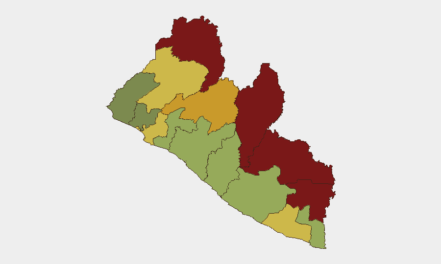
Liberia remains a lower-tier global security risk (ranked #152 globally) with limited major incidents reported in the past week. However, underlying governance and law-enforcement challenges—including prison overcrowding, informal justice mechanisms, and localized administrative breakdowns—create persistent vulnerability to escalation. The southeastern and northeastern border counties (Nimba, Lofa, Grand Gedeh, River Gee) carry substantially elevated risk profiles and warrant differentiated monitoring.
Key Developments
- Monrovia, October 5: The Ministry of Gender, Children and Social Protection condemned circulation of a video involving an alleged sexual encounter between a teenager and a 29-year-old man; police engagement initiated.
- Monrovia, October 5: The Monrovia City Government continued enforcement of sanitation ordinances, with multiple arrests reported for illegal dumping and littering.
- Nimba County, October 1: Traditional leaders reportedly agreed to remove roadblocks previously established in the county; limited detail available on scope, locations, or underlying grievances.
- Sinoe County, October 1: The county attorney was reportedly assaulted by an aide to the superintendent; details on injuries and police response remain incomplete.
- Liberia-wide, September 30–October 6: No change in U.S. travel advisory level; Liberia remains classified as Level 2: Exercise Increased Caution, consistent with prior advisories.
- Liberia-wide, October 6: Policy review flagged concerns regarding illegal mining operations and enforcement gaps within the government's Protect Our Resources Taskforce, reflecting structural governance weakness rather than a discrete incident.
Historical context (not current developments): September 20 saw more than 100 inmates escape Kakata Central Prison following an inmate death attributed to overcrowding, and September 24 saw police arrest an individual over alleged distribution of AI-generated imagery involving the Vice President; these prior-week incidents underscore institutional fragility.
Highest-Risk Areas
Nimba (92), Lofa (88), and Grand Gedeh (85) counties—all in the northeastern and eastern border regions—carry risk scores nearly 10 times the national average, driven by limited state presence, informal dispute resolution, cross-border movement, and weak law-enforcement infrastructure. River Gee and Bong counties follow, while Montserrado (which includes Monrovia) scores lower despite population concentration, reflecting somewhat stronger government capacity in the capital. The risk gradient suggests that organizations with field presence in the interior should prioritize intelligence and early-warning focus on the northeastern quadrant.
How GeoBit Would Assist
Security teams should deploy Area-of-Interest (AOI) Monitoring & Early Warning on high-risk counties (particularly Nimba, Lofa, and Grand Gedeh) to flag localized unrest, roadblocks, or administrative breakdowns before they affect staff movement. Multi-language OSINT and X/Telegram monitoring would capture early signals of informal justice actions, community grievances, or security force responses that wire-service coverage may miss. Routing & Network Analysis can provide real-time alternative journey planning when primary road corridors are compromised by roadblocks or unrest, and conflict and crime pattern search can contextualize emerging incidents against longer-term trends to distinguish isolated events from escalating patterns.
7-Day Outlook
No major escalation is forecast for the immediate week; however, the combination of prison overcrowding, informal roadblocking in the interior, and localized administrative friction suggests continued potential for small-scale flare-ups in Nimba and Lofa counties. Organizations should monitor Monrovia's enforcement actions (sanitation, gender-based violence response) as indicators of government capacity and community tension. Routine vigilance and passive monitoring remain appropriate; reactive escalation is not currently anticipated.
Highest-Risk Areas — Ranked
| # | State / Region | Risk |
|---|---|---|
| 1 | Nimba County | 92 |
| 2 | Lofa County | 88 |
| 3 | Grand Gedeh County | 85 |
| 4 | River Gee County | 83 |
| 5 | Bong County | 72 |
| 6 | Gbarpolu County | 68 |
| 7 | Grand Kru County | 65 |
| 8 | Montserrado County | 64 |
| 9 | Rivercess County | 58 |
| 10 | Sinoe County | 55 |
| 11 | Margibi County | 52 |
| 12 | Grand Bassa County | 48 |
Sources
Previous Weekly Briefs
A new Liberia brief is written every Monday, covering the week — each with its own risk map and downloadable CSV. Use the calendar to go further back.
- September 29, 2026
- September 22, 2026
- September 15, 2026
- September 8, 2026
- September 2, 2026
- August 31, 2026
- August 28, 2026
📅 Browse past briefs by calendar →
Highlighted days have a brief. Tap a day for that day's map & analysis, or “csv” for that day's dataset ($5).
Atlas — our AI intelligence desk — emails them this snapshot personally. Nothing else, no list.