Situation Summary
Namibia remains a stable, low-threat environment globally (#102 overall; composite score 14), with no organized armed conflict or state-level instability. However, interpersonal violence—including homicide, sexual assault, and domestic violence—continues at a steady baseline, with five verified incidents recorded in the past 48 hours across multiple regions. Road-safety fatalities and occupational hazards (toxic exposure) also feature in the current reporting window. Risk is heavily concentrated in the northern and northeastern border regions.
Key Developments
- Oniimwandi village, Onayena – Friday, 2026-08-07 – Police arrested a suspect following an alleged domestic-violence-related attempted murder involving three victims; all victims treated at Onandjokwe Hospital.
- Etalaleko location, Iipandahangano village, Outapi – Friday, 2026-08-07 – Man fatally stabbed in chest with Okapi knife during altercation; suspect arrested and weapon recovered.
- Ubib Reserve, Karasburg – Saturday, 2026-08-08 – Fatal stabbing during interpersonal conflict; victim died after transport to Karasburg State Hospital.
- Gammams Water Care Works, Windhoek – Thursday, 2026-08-07 – Two Cape Advanced Engineering Namibia employees died following suspected toxic gas exposure during occupational activity.
- Unconfirmed road-traffic fatality – Friday/Saturday, 2026-08-08 – Fatal multi-vehicle collision resulting in two child fatalities; recent documented road-safety incident in current window.
All incidents involve interpersonal or occupational hazards rather than organized criminal activity, civil unrest, or political instability. No credible threat to corporate or expatriate populations detected in reporting period.
Highest-Risk Areas
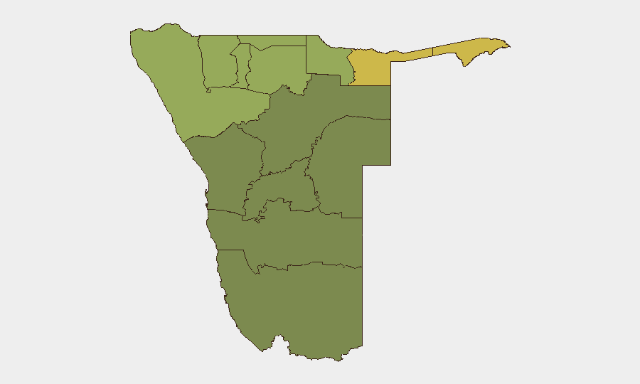
Zambezi Region (score 68) and the two Kavango regions (East 62, West 58) drive sub-national risk rankings, reflecting border-proximity vulnerabilities, limited state capacity, and historical patterns of cross-border movement and informal-economy activity. Kunene Region (52) and Oshikoto (48) similarly reflect northern-border characteristics. In contrast, central and southern regions (Hardap 28, Omaheke 25) and the coastal Erongo (32) register lower composite scores, correlating with higher urbanization, police presence, and economic formality. Risk concentration in the north is consistent with Namibia's geographic and institutional footprint but does not translate to active conflict or organized-crime dominance in any region.
How GeoBit Would Assist
Security teams with personnel or assets in Namibia should leverage AOI Monitoring & Early Warning to track the highest-risk northern regions (Zambezi, Kavango East/West) for emerging patterns in cross-border movement, informal settlements, or labor-sector incidents. Intel Sweep and multi-language OSINT (via social media, local radio, and community sources) enable real-time alerting on localized interpersonal violence, occupational safety failures, and road-traffic incidents affecting supply chains or staff movement. Routing & Network Analysis supports alternative-route planning for field teams, particularly in Kunene and Oshikoto, to avoid high-incident corridors during night hours or periods of elevated tension.
7-Day Outlook
Namibia's security profile is expected to remain stable over the next seven days, with baseline-level interpersonal violence and occupational incidents continuing but no escalation in organized crime, civil unrest, or cross-border instability anticipated. Northern regions will remain the primary focus for duty-of-care monitoring; no specific threats to corporate or expatriate operations are identified in the current reporting window.
Highest-Risk Areas — Ranked
| # | State / Region | Risk |
|---|---|---|
| 1 | Zambezi | 68 |
| 2 | Kavango East | 62 |
| 3 | Kavango West | 58 |
| 4 | Kunene Region | 52 |
| 5 | Oshikoto | 48 |
| 6 | Ohangwena | 45 |
| 7 | Omusati | 42 |
| 8 | Oshana | 40 |
| 9 | Otjozondjupa | 35 |
| 10 | Erongo Region | 32 |
| 11 | Hardap | 28 |
| 12 | Omaheke | 25 |
Sources
Previous Daily Briefs
A new Namibia brief is written every day — each with its own risk map and downloadable CSV. Here's the last week; use the calendar to go further back.
📅 Browse every day by calendar →
Highlighted days have a brief. Tap a day for that day's map & analysis, or “csv” for that day's dataset ($5).
Atlas — our AI intelligence desk — emails them this snapshot personally. Nothing else, no list.