Situation Summary
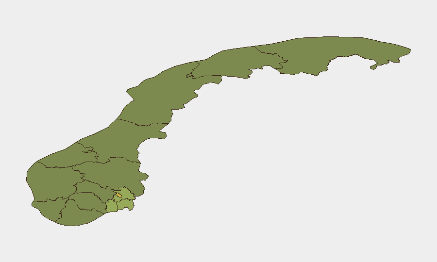
Norway remains a low-threat environment (global rank #44, composite score 35) with no tracked major incidents or organized instability. Recent activity consists of isolated urban crime, routine police operations, and two fatal transport accidents; no terrorism, civil unrest, or political violence has been confirmed in the last 48 hours. The security picture is stable, with localized crime clusters in Oslo and Agder reflecting normal urban patterns rather than escalating risk.
Key Developments
- E16 Aurland, Vestland – fatal head-on collision, 5 August 01:42. A 21-year-old male died in a collision with a heavy truck between Gudvangen and Flenja tunnels; truck driver unharmed and not suspected of wrongdoing. Impact: local traffic disruption on a key east–west corridor.
- Breheimen and Jotunheimen mountain regions, Innlandet/Vestland – three rescue operations over 4 days, latest within 48 hours. Multiple distressed hikers extracted from difficult alpine terrain; no wider security implications but elevated wilderness-travel risk.
- Fløysbonn secondary school, Nordre Follo – arrest of male teacher, 5 August. Police arrested and remanded a man in his 40s on suspicion of sexual abuse; school-specific safeguarding concern.
- Jæren, Agder – death treated as criminal case, 4 August. Woman in her 30s found dead; suspect in custody. National police cited incident as part of recent violent-crime cluster.
- Bergen/Haakonsvern naval base, Vestland – KNM Fridtjof Nansen return from NATO exercise, 5 August. Frigate returned to home base after large-scale NATO operation; routine military movement with no incident.
- Lillestrøm and Ringsaker – serious assault and armed robbery, 4 August. Two violent incidents (one assault in Lillestrøm, one violent theft in Ringsaker) contributing to noted national pattern of serious crime per police leadership.
- Kristiansand city centre – violent assault and public-order arrests, 29 July. Man in his 20s arrested for assault on man in his 30s (victim hospitalized); two additional men arrested for public-order disturbance same night.
Highest-Risk Areas
Oslo (risk 68) and Akershus (risk 52) dominate the sub-national ranking and account for the majority of recent violent-crime incidents, including assaults, custodial disturbances, and weapons-related police responses. Agder emerges as a secondary concern (risk 26) with recent homicide and serious assault, while southern corridor regions (Østfold, Vestfold, Rogaland) maintain moderate elevated scores driven by urban crime clusters. Northern and rural areas (Innlandet, Møre og Romsdal, Trøndelag) show lower composite risk, though wilderness-travel hazards currently elevated in mountain zones.
How GeoBit Would Assist
Teams with personnel or assets in Oslo, Akershus, or Agder should deploy AOI Monitoring & Early Warning (persistent watch on these high-risk zones with alerting) paired with Intel Sweep and OSINT (daily event-feed synthesis and social-media sentiment monitoring to detect escalation patterns early). For mobile or traveling staff, Routing & Network Analysis enables real-time alternative-journey planning to avoid clusters; cross-referenced with conflict and crime search to build situational awareness before deployment.
7-Day Outlook
No major escalation expected; the current pattern reflects routine urban crime and transport-safety risk rather than systemic instability. Monitoring should remain routine but persistent in Oslo and Agder. Weather and mountain conditions will likely sustain elevated wilderness-rescue activity through August.
Highest-Risk Areas — Ranked
| # | State / Region | Risk |
|---|---|---|
| 1 | Oslo | 68 |
| 2 | Akershus | 52 |
| 3 | Østfold | 48 |
| 4 | Vestfold | 42 |
| 5 | Rogaland | 38 |
| 6 | Buskerud | 35 |
| 7 | Trøndelag | 32 |
| 8 | Telemark | 28 |
| 9 | Vestland | 27 |
| 10 | Agder | 26 |
| 11 | Møre og Romsdal | 22 |
| 12 | Innlandet | 20 |
Sources
Previous Daily Briefs
A new Norway brief is written every day — each with its own risk map and downloadable CSV. Here's the last week; use the calendar to go further back.
📅 Browse every day by calendar →
Highlighted days have a brief. Tap a day for that day's map & analysis, or “csv” for that day's dataset ($5).
Atlas — our AI intelligence desk — emails them this snapshot personally. Nothing else, no list.