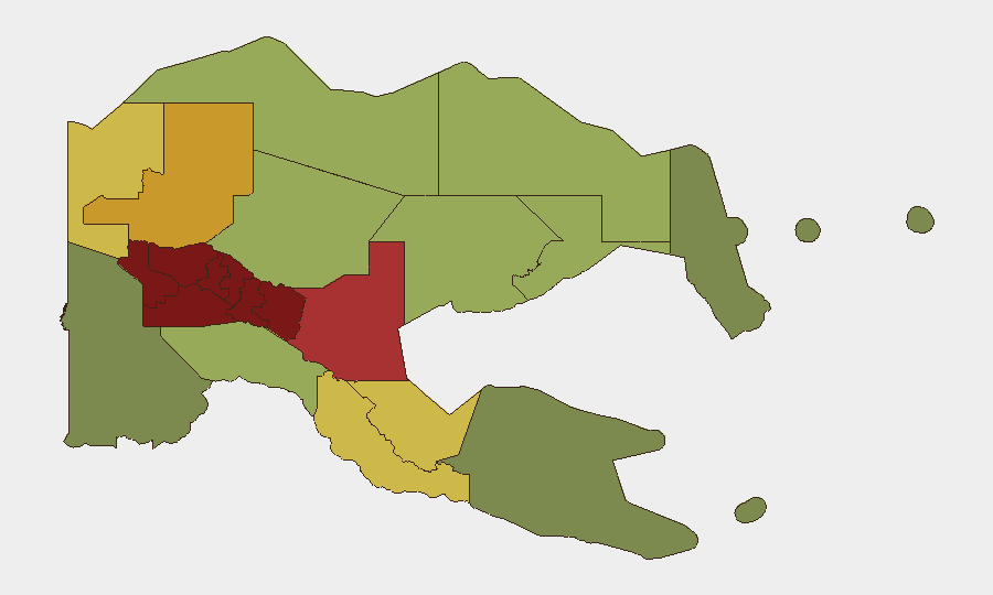
Situation Summary
Papua New Guinea remains at composite threat rank #81 globally with an elevated risk profile driven by persistent violent crime, civil disorder, and limited state capacity in highland and urban zones. A 14-day State of Emergency declared on 8 August 2026 following widespread rioting and looting in the National Capital District reflects acute instability in Port Moresby; simultaneously, highland provinces (Southern Highlands, Enga, Hela, Eastern Highlands) continue to experience chronic armed violence and tribal conflict. No major escalation has been reported in the last 24–48 hours, but the operating environment remains volatile and fragmented by subnational geography.
Key Developments
- National Capital District, 6–8 August 2026: Widespread rioting and looting triggered declaration of a 14-day State of Emergency on 8 August; extent of damage and displacement still being assessed; heightened police and military presence expected through mid-August.
- Grand Eden Estate (Port Moresby vicinity), 8 August 2026: Armed public fight resulted in 14 arrests; detainees held at Six Mile Police Station; no confirmed deaths reported but incident reflects ongoing urban violence clustering.
- Port Moresby, 7 August 2026: Death of Richmond Aaron following serious wounding in early hours of 7 August; circumstances under police investigation; incident type consistent with escalating interpersonal/gang violence in NCD.
- East Sepik Province, recent (exact date not pinned): Police arrested four suspects in connection with the murder of four people from Haripmo village; operation ongoing and suggests organized or mass-casualty crime activity in outlying regions.
- Wewak–Maprik route, East Sepik Province, recent: Two armed men apprehended on a PMV (public minibus) traveling between Wewak and Maprik; indicates armed movement and transport-corridor vulnerability in provincial zones.
- Wabag, Enga Province, 29 July 2026 (background context): Sixteen remandees escaped from Wabag Police Station; recapture operation underway; reflects institutional weakness and detention-security risk in highland areas.
Highest-Risk Areas
Southern Highlands, Enga, Hela, and Eastern Highlands provinces dominate the risk ranking (composite scores 94–98), driven by endemic tribal and land-dispute violence, limited police presence, and weak infrastructure. The National Capital District (rank 7, score 85) has recently risen to acute concern following the 6–8 August riots and State of Emergency declaration, with secondary cities and transport corridors (Wewak, Maprik, Morobe) showing elevated crime and armed-group activity. Corporate and NGO presence in these zones faces compounded exposure to civil unrest, armed assault, supply-chain disruption, and state-capacity gaps.
How GeoBit Would Assist
Security and risk teams should employ AOI Monitoring & Early Warning to track flashpoints in the NCD, highlands, and provincial transport corridors with real-time alerting on riot, armed-group, and crime signals; Intel Sweep and multi-language OSINT (including X/Twitter and local news feeds) to detect emerging tribal disputes, police actions, and civil-order shifts; and Routing & Network Analysis to identify safe alternative transport and supply routes during periods of elevated unrest. Satellite & Imagery analysis can confirm damage extent and displacement in Port Moresby and monitor state-capacity deployment.
7-Day Outlook
The State of Emergency is expected to persist through mid-August with police and military enforcement focused on Port Moresby; secondary urban areas may experience brief spillover unrest or copy-cat incidents. Highland violence is likely to remain chronic and subnational; no major escalation is currently signaled, but institutional weakness and fragmented governance create persistent risk of rapid localized flare-ups.
Highest-Risk Areas — Ranked
| # | State / Region | Risk |
|---|---|---|
| 1 | Southern Highlands | 98 |
| 2 | Enga | 96 |
| 3 | Hela | 94 |
| 4 | Eastern Highlands | 92 |
| 5 | Western Highlands | 90 |
| 6 | Jiwaka | 88 |
| 7 | National Capital District | 85 |
| 8 | Simbu | 82 |
| 9 | Morobe | 78 |
| 10 | East Sepik | 72 |
| 11 | Sandaun | 68 |
| 12 | Oro | 66 |
Sources
Previous Daily Briefs
A new Papua New Guinea brief is written every day — each with its own risk map and downloadable CSV. Here's the last week; use the calendar to go further back.
📅 Browse every day by calendar →
Highlighted days have a brief. Tap a day for that day's map & analysis, or “csv” for that day's dataset ($5).
Atlas — our AI intelligence desk — emails them this snapshot personally. Nothing else, no list.