Situation Summary
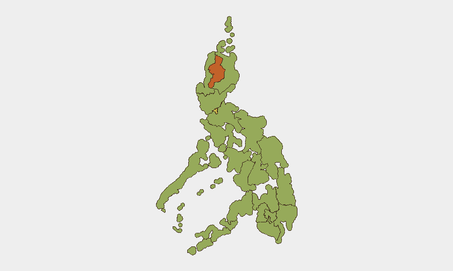
Philippines remains at composite threat level #32 globally (score 66/100) with 69 tracked events, reflecting a mixed security landscape dominated by regional volatility, political friction, and environmental hazards. The past 48 hours have seen a high-profile corruption prosecution, volcanic activity requiring evacuation monitoring, and localized flooding in already-sensitive areas, while a major religious rally concluded without incident. The country's risk profile is heavily concentrated in the Cordillera Administrative Region (75.9) and Metro Manila (64.4), with secondary hotspots across Mindanao and Visayas regions; trajectory remains volatile but not acutely destabilizing at the national level.
Key Developments
- Metro Manila, July 3: National Capital Region Police Office downgraded alert status to "heightened alert" following the conclusion of a large Iglesia Ni Cristo rally with no reported security incidents, indicating improved near-term conditions in the capital region.
- Manila, July 3: Ombudsman filed a plunder case before the Sandiganbayan against Congressman Rodante Marcoleta involving approximately ₱75 million, signaling continued high-level anti-corruption enforcement with potential political reverberations.
- Mayon Volcano area (Albay Province, Bicol Region), July 3: Philippine Institute of Volcanology and Seismology (PHIVOLCS) reported active lava flow from the crater, necessitating continued monitoring for escalation and potential evacuation disruptions in surrounding communities.
- Iligan City (Lanao del Norte), July 3: Heavy rainfall triggered flooding across multiple barangays, disrupting local transport and creating immediate access and mobility risks in the Mindanao region.
- Maguindanao del Sur (Bangsamoro Autonomous Region), July 3: Concurrent heavy rains caused flooding in barangays, compounding displacement and transport disruption in an area already subject to elevated security and conflict sensitivities.
- Manila, July 3: Ateneo de Manila University announced assistance to individuals named in a Criminal Investigation and Detection Group (CIDG) recommendation, reflecting ongoing law-enforcement investigations with potential institutional and reputational implications.
Highest-Risk Areas
Cordillera Administrative Region (75.9) and Metro Manila (64.4) account for the largest composite risk concentrations, driven by historical armed-group activity, mining-sector tensions, and urban crime/protest density respectively. Mimaropa (58.2) and Eastern Visayas (50.6) present secondary risk clusters linked to maritime piracy, armed communist activity, and infrastructure vulnerability. The Bangsamoro Autonomous Region and broader Mindanao provinces (Maguindanao del Sur, Caraga, Northern Mindanao, Davao, Soccsksargen all at 45.9) remain structurally vulnerable to extremist operations, clan-based violence, and environmental disruption; recent flooding in Maguindanao del Sur illustrates how weather hazards intersect with pre-existing governance and security deficits.
How GeoBit Would Assist
GeoBit's AOI Monitoring & Early Warning capability would enable continuous watch on Cordillera, Bangsamoro, and Eastern Visayas regions to detect upticks in armed activity or protest mobilization. OSINT Fusion across social media (X, Telegram) and news feeds would provide real-time intelligence on political prosecutions, volcanic escalation, and law-enforcement operations, allowing duty-of-care teams to anticipate restricted movements or curfews. GIS & Satellite Imagery Analysis would track Mayon Volcano activity and flood extent to support evacuation planning and route diversification for personnel in affected provinces.
7-Day Outlook
No acute national-level destabilization is forecast, but the convergence of environmental hazards (Mayon, flooding), political friction (corruption cases, presidential tensions), and persistent regional armed activity in Mindanao will likely sustain operational friction and localized mobility challenges. Organizations with personnel in Cordillera, Metro Manila, or Bangsamoro should maintain heightened situational awareness and contingency logistics through mid-July.
Highest-Risk Areas — Ranked
| # | State / Region | Risk |
|---|---|---|
| 1 | Cordillera Administrative Region | 75.9 |
| 2 | Metro Manila | 64.4 |
| 3 | Mimaropa | 58.2 |
| 4 | Eastern Visayas | 50.6 |
| 5 | Ilocos Region | 46.8 |
| 6 | Central Luzon | 46.3 |
| 7 | Bangsamoro | 45.9 |
| 8 | Caraga | 45.9 |
| 9 | Northern Mindanao | 45.9 |
| 10 | Soccsksargen | 45.9 |
| 11 | Davao Region | 45.9 |
| 12 | Cagayan Valley | 45.9 |
Sources
Previous Daily Briefs
A new Philippines brief is written every day — each with its own risk map and downloadable CSV. Here's the last week; use the calendar to go further back.
📅 Browse every day by calendar →
Highlighted days have a brief. Tap a day for that day's map & analysis, or “csv” for that day's dataset ($5).