Situation Summary
Solomon Islands remains in a low-incident security environment as of 28 August 2026, with no corroborated discrete security events, civil unrest, or infrastructure disruptions reported in the past 24–48 hours. The country's composite threat score of 7 (ranked #148 globally) reflects endemic structural risks—urban crime, legacy conflict artifacts, and natural hazards—rather than acute political instability or armed activity. Honiara and Guadalcanal Province continue to carry elevated risk profiles relative to outer islands, but baseline conditions show no escalation from recent weeks.
Key Developments
- No corroborated incidents in the last 24–48 hours (27–28 August 2026) across security, crime, unrest, infrastructure, or political domains meet multi-source verification thresholds. Open-source reporting and regional security briefs characterize the current window as incident-free.
- Honiara remains highest-risk urban center (risk score 92), driven by persistent street crime, gang activity, and historical protest volatility in central business and Chinatown zones; no new incidents flagged in the past two days.
- Baseline advisory posture unchanged: Travel-risk assessments updated in August 2026 maintain "low overall risk" rating with "travel with caution" guidance. No new curfews, movement restrictions, or emergency directives have been announced.
- Chronic hazard exposure persists: Unexploded ordnance from WWII remains a threat in specific rural and coastal areas; cyclone and tsunami risk remains seasonal and permanent, unrelated to recent events.
- No political triggering events in the immediate window; regional and national political calendar does not show imminent elections, constitutional votes, or foreign-policy crises scheduled for late August 2026.
Highest-Risk Areas
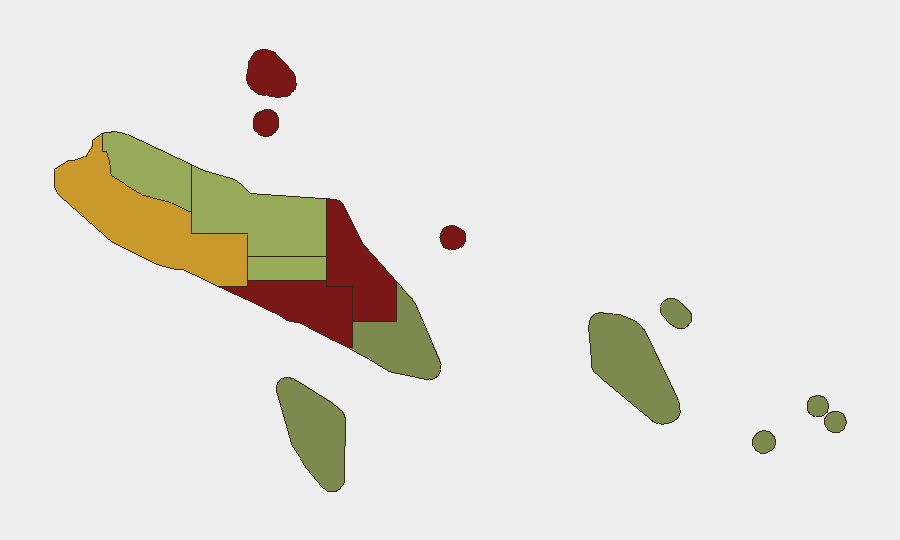
Honiara (risk 92) and Guadalcanal Province (risk 88) drive the national risk profile, reflecting concentrated urban crime, social fragmentation, and a history of rapid unrest escalation (notably the 2021 riots). Malaita Province (risk 85) follows, reflecting communal tensions and resource competition rooted in inter-provincial dynamics. Risk gradients decline sharply beyond these three provinces, with Temotu and Rennell and Bellona (scores 18 and 22, respectively) representing minimal acute threat. The concentration of risk in Honiara and its hinterland means that corporate and NGO personnel should apply differentiated posture: heightened situational awareness and contingency planning for urban centers; standard precautions for outer islands.
How GeoBit Would Assist
Security teams with personnel or assets in Solomon Islands should use AOI (Area-of-Interest) Monitoring & Early Warning to track Honiara and Guadalcanal with persistent alerting for protest activity, roadblocks, or curfew announcements. Intel Sweep and multi-source OSINT fusion (X/Twitter, Telegram, local media, and radio SIGINT) would provide 24-hour coverage of political messaging, social unrest signals, and community sentiment shifts that precede escalation. Routing & Network Analysis should be applied to pre-plan alternative transport corridors and safe havens in case central Honiara becomes inaccessible.
7-Day Outlook
Conditions are forecast to remain stable through early September, with no identified political or economic triggers scheduled to drive acute unrest in the next 7 days. Seasonal cyclone and seismic hazard monitoring should remain active as routine precaution. Continued passive OSINT and AOI monitoring are warranted to detect any shift in political rhetoric or community mobilization that could signal emerging civil disturbance.
Highest-Risk Areas — Ranked
| # | State / Region | Risk |
|---|---|---|
| 1 | Honiara | 92 |
| 2 | Guadalcanal | 88 |
| 3 | Malaita | 85 |
| 4 | Western | 72 |
| 5 | Choiseul | 58 |
| 6 | Isabel | 52 |
| 7 | Central Province | 48 |
| 8 | Makira-Ulawa | 38 |
| 9 | Rennell and Bellona | 22 |
| 10 | Temotu | 18 |
Sources
Previous Daily Briefs
A new Solomon Islands brief is written every day — each with its own risk map and downloadable CSV. Here's the last week; use the calendar to go further back.
- August 26, 2026
- August 24, 2026
- August 22, 2026
- August 20, 2026
- August 18, 2026
- August 16, 2026
- August 14, 2026
📅 Browse every day by calendar →
Highlighted days have a brief. Tap a day for that day's map & analysis, or “csv” for that day's dataset ($5).
Atlas — our AI intelligence desk — emails them this snapshot personally. Nothing else, no list.