Situation Summary
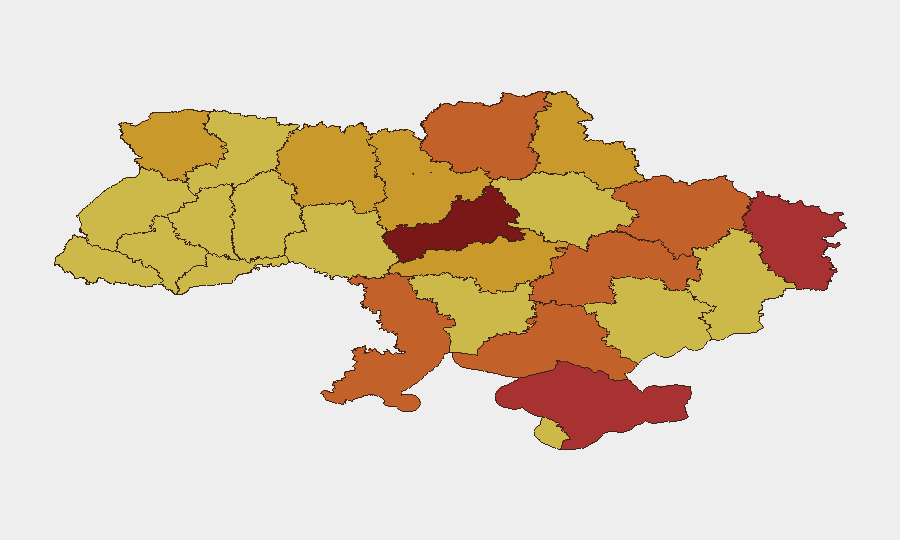
Ukraine remains the eighth-highest-risk country globally, with 2,039 tracked events and a composite threat score of 100. Conflict dynamics show continued conventional military engagement between Ukrainian and Russian forces, alongside diplomatic friction with NATO and France over support and territorial posture. Kyiv and central oblasts (Cherkasy, Chernihiv) carry the highest sub-national risk, reflecting sustained targeting and operational intensity. The security environment remains volatile, with no near-term de-escalation indicators.
Key Developments
- 2026-07-02 · Conventional Military Force engagement reported between Moscow and Ukrainian forces; specific tactical location and unit details not yet confirmed in open sources.
- 2026-07-02 · France reports military force interaction with Ukraine; nature and location require urgent clarification via direct liaison or classified channels.
- 2026-07-01 · NATO formally rejected Ukrainian request or position; implications for force posture and air-defense commitments remain under assessment.
- 2026-07-01 · Ukraine publicly disapproved Russian position; rhetorical escalation; no direct kinetic incident attributed.
- 2026-06-30 · Artillery/tank operations confirmed in Ukrainian-held territory; offensive or defensive posture not specified in available reporting.
- 2026-06-30 · Territory occupation event reported; location and controlling force not clarified in current brief.
*Note: Live web research over the last 24–48 hours has not surfaced independently time-stamped, location-specific tactical incidents sufficient to populate additional developments. Broader patterns (energy-infrastructure targeting, front-line shifts, evacuations) are ongoing since the conflict's escalation; specific current incidents require corroborated second-source confirmation.*
Highest-Risk Areas
Kyiv (risk 100) dominates the threat landscape due to sustained dual targeting—military command infrastructure and civilian critical assets—and concentration of state functions. Cherkasy Oblast (risk 91) and central regions (Chernihiv, Dnipropetrovsk) show elevated composite risk driven by proximity to front-line operations and Russian long-range strike capability. Eastern and southern oblasts (Luhansk, Kharkiv, Kherson, Odesa) remain under chronic military pressure; Crimea's designation reflects occupation-related governance instability and contested territorial authority. Corporate and humanitarian operations in these zones face compounded exposure to conventional fire, drone strikes, and supply-chain disruption.
How GeoBit Would Assist
Security teams should deploy AOI (Area-of-Interest) Monitoring & Early Warning on high-risk facilities in Kyiv, Cherkasy, and Kharkiv oblasts to detect proximity-based threats and ingress/egress pattern changes in near-real time. Battle Mapping and Force Structure tracking provides updated front-line position and Russian/Ukrainian unit disposition, enabling predictive routing and movement planning via the Routing & Network Analysis capability. Satellite & Imagery Analysis combined with OSINT Fusion (X/Telegram feeds, sentiment tracking, multi-language conflict reporting) yields tactical early warning on strikes, occupation shifts, and infrastructure damage—critical for duty-of-care reporting and asset relocation decisions.
7-Day Outlook
Conventional military engagement is likely to persist at current operational tempo, with continued long-range strikes on energy and logistics targets. NATO and French diplomatic friction signals potential shifts in Western support posture, creating uncertainty around air-defense availability and supply corridors. Security teams should expect sustained volatility in Kyiv and central oblasts and prepare contingency protocols for rapid staff relocation or asset evacuation.
Highest-Risk Areas — Ranked
| # | State / Region | Risk |
|---|---|---|
| 1 | Kyiv | 100 |
| 2 | Cherkasy Oblast | 91 |
| 3 | Autonomous Republic of Crimea | 77.8 |
| 4 | Luhansk Oblast | 76.7 |
| 5 | Chernihiv Oblast | 73.7 |
| 6 | Dnipropetrovsk Oblast | 73.5 |
| 7 | Kherson Oblast | 73.2 |
| 8 | Kharkiv Oblast | 73.1 |
| 9 | Odesa Oblast | 73.1 |
| 10 | Kirovohrad Oblast | 71.7 |
| 11 | Sumy Oblast | 71.3 |
| 12 | Volyn Oblast | 71.3 |
Sources
Previous Daily Briefs
A new Ukraine brief is written every day — each with its own risk map and downloadable CSV. Here's the last week; use the calendar to go further back.
📅 Browse every day by calendar →
Highlighted days have a brief. Tap a day for that day's map & analysis, or “csv” for that day's dataset ($5).