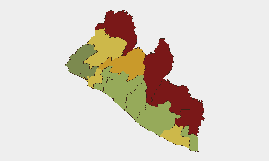
Situation Summary
Liberia remains a low-threat environment globally (rank #153), but faces persistent localized criminal activity and institutional vulnerabilities. The past week has seen high-profile arrests related to cybercrime, counterfeiting, and transnational drug trafficking—including allegations involving senior political figures—signaling both investigative momentum and potential organized-crime networks operating in the capital. The eastern border counties (Nimba, Lofa, Grand Gedeh) continue to carry elevated risk profiles, though no acute security incidents have been reported in those areas this week.
Key Developments
- October 6 — Paynesville (Rehab, SKD, Baptist Seminary): Liberia National Police executed joint search-and-seizure warrants targeting suspected cybercrime, forgery, counterfeiting, and economic sabotage. Operations resulted in arrest of 67 foreign nationals and seizure of over 200 mobile phones, 50+ computers, and suspected counterfeit currency.
- October 7 — Monrovia (Criminal Court "C"): Grand jury indictment named 20 individuals in an alleged transnational drug-trafficking and money-laundering conspiracy, reportedly including former Vice President Jewel Howard-Taylor and current or former security officials.
- October 8 — Monrovia: Police Inspector General publicly confirmed the October 6 raids and announced ongoing investigative examination of cybercrime, counterfeiting, forgery, and economic-sabotage charges.
- September 29 — Monrovia (market, unspecified location): Women's-rights organization condemned reported mob violence, including assaults and public stripping/humiliation of women; underlying cause and perpetrators remain unclear.
- September 29 — Monrovia (sanitation enforcement): Monrovia City Corporation arrests continued in littering and illegal dumping operations; routine law-enforcement activity.
Highest-Risk Areas
Nimba, Lofa, and Grand Gedeh counties occupy the top three risk positions (scores 92, 88, 85 respectively), reflecting a concentration of threat drivers in Liberia's eastern border region. These counties have historically faced cross-border trafficking, informal armed groups, and weak state capacity; no acute incident reporting this week suggests the risk profile is structural rather than driven by immediate escalation. Montserrado County (rank 8, score 64)—which includes Monrovia—registers moderate risk, consistent with urban-crime activity (cybercrime networks, trafficking) observed this week but below the border-region baseline.
How GeoBit Would Assist
Organizations with personnel or assets in Liberia should employ Intel Sweep and global event feeds for real-time incident monitoring across Monrovia and eastern counties, combined with Network & Actor Analysis to map the transnational cybercrime and trafficking networks now visible to Liberian law enforcement. AOI Monitoring & Early Warning on Nimba, Lofa, and Grand Gedeh counties would provide persistent watch for cross-border activity, trafficking movements, or armed-group activity that might escalate beyond current background levels.
7-Day Outlook
The indictment of senior political figures and ongoing arrests suggest intensifying law-enforcement operations against organized crime and financial fraud, which may produce additional high-profile developments over the coming week. No imminent surge in street violence, civil unrest, or border-area instability is indicated; risk remains localized to criminal networks and urban centers. Eastern counties should continue to be monitored for cross-border trafficking or informal armed-group activity, though no specific threat signal has emerged this reporting period.
Highest-Risk Areas — Ranked
| # | State / Region | Risk |
|---|---|---|
| 1 | Nimba County | 92 |
| 2 | Lofa County | 88 |
| 3 | Grand Gedeh County | 85 |
| 4 | River Gee County | 83 |
| 5 | Bong County | 72 |
| 6 | Gbarpolu County | 68 |
| 7 | Grand Kru County | 65 |
| 8 | Montserrado County | 64 |
| 9 | Rivercess County | 58 |
| 10 | Sinoe County | 55 |
| 11 | Margibi County | 52 |
| 12 | Grand Bassa County | 48 |
Sources
Previous Weekly Briefs
A new Liberia brief is written every Monday, covering the week — each with its own risk map and downloadable CSV. Use the calendar to go further back.
- October 6, 2026
- September 29, 2026
- September 22, 2026
- September 15, 2026
- September 8, 2026
- September 2, 2026
- August 31, 2026
📅 Browse past briefs by calendar →
Highlighted days have a brief. Tap a day for that day's map & analysis, or “csv” for that day's dataset ($5).
Atlas — our AI intelligence desk — emails them this snapshot personally. Nothing else, no list.