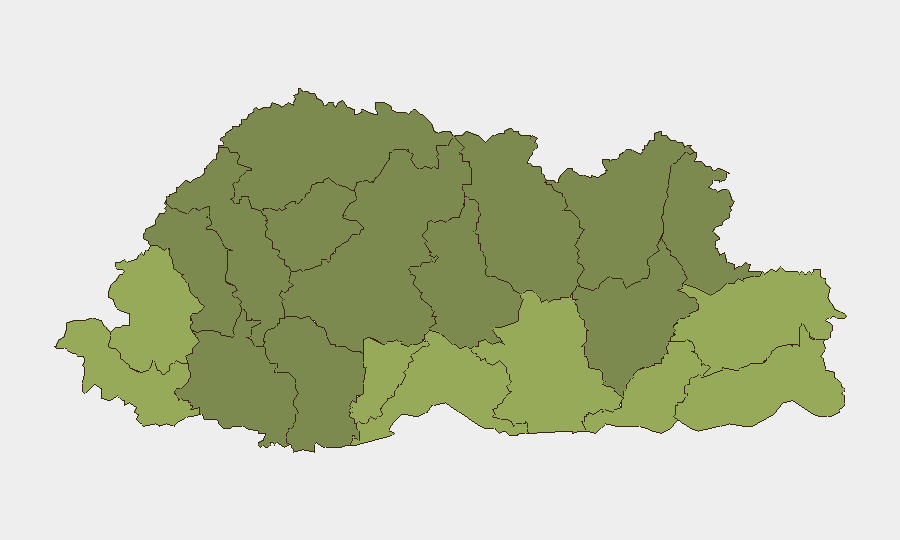
Situation Summary
Bhutan remains one of the world's lowest-threat operating environments, with a composite national threat score of 3 and zero tracked security incidents in the current monitoring window. No discrete civil unrest, armed conflict, organized crime escalations, infrastructure disruptions, or political instability events were confirmed in the last 24–48 hours. Risk concentration is sub-national and concentrated in southern border districts; the country's overall security posture remains stable.
Key Developments
- Nationwide, 21–22 July 2026: Multi-source monitoring confirmed zero security incidents, civil unrest, crime events, or infrastructure disruptions across Bhutan in the 24–48 hour window.
- Thimphu, 20 July 2026: Thromde (municipal) elections recorded 33.92% voter turnout; classified as electoral/administrative activity, not a security event.
- Samtse District, 22 July 2026: Highest sub-national risk area (score 58) remained under routine border monitoring; no new escalations or specific incidents confirmed in the current period.
- Sarpang District, 22 July 2026: Second-highest sub-national risk area (score 55) continued elevated monitoring; no newly reported security incidents in the window.
- Haa, Pemagatshel Districts, 22 July 2026: Both elevated-risk border regions maintained routine watch status; no confirmed disruptions or incidents reported.
Highest-Risk Areas
Samtse, Sarpang, and Haa districts in southern and southwestern Bhutan drive the country's sub-national risk profile (scores 58, 55, and 52 respectively). These districts sit along Bhutan's international borders and experience elevated monitoring for cross-border movement, smuggling, and irregular migration—baseline friction points common to border zones globally. None currently show active escalation. The remaining high-risk districts (Pemagatshel, Samdrup Jongkhar, Tsirang) follow similar geographic and functional profiles. Central and northern districts (Lhuntse, Gasa, Wangdue Phodrang) score significantly lower and remain low-friction.
How GeoBit Would Assist
Organizations with personnel or assets in Bhutan, particularly in southern border districts, should employ AOI Monitoring & Early Warning on Samtse, Sarpang, and Haa to detect any cross-border movement, irregular activity, or infrastructure disruption in real time. OSINT Sweep and multi-language search (Dzongkha, English, regional outlets) provide continuous intelligence fusion on border-watch developments and local administrative activity. GIS & Spatial Analysis and Routing & Network Analysis enable alternative-route planning and asset-location risk mapping should conditions change rapidly.
7-Day Outlook
Bhutan's security trajectory remains flat and low-risk over the next seven days. No intelligence signals suggest imminent escalation in border districts or nationwide political, economic, or infrastructure stress. Routine border monitoring will continue in southern districts; the country's stable governance environment and low crime baseline are expected to persist.
Next Update: 30 July 2026 | Data Cutoff: 29 July 2026, 06:00 UTC
Highest-Risk Areas — Ranked
| # | State / Region | Risk |
|---|---|---|
| 1 | Samtse District | 58 |
| 2 | Sarpang District | 55 |
| 3 | Haa District | 52 |
| 4 | Pemagatshel District | 50 |
| 5 | Samdrup Jongkhar District | 48 |
| 6 | Tsirang District | 45 |
| 7 | Zhemgang District | 42 |
| 8 | Trashigang District | 40 |
| 9 | Mongar District | 38 |
| 10 | Gasa District | 35 |
| 11 | Lhuntse District | 32 |
| 12 | Wangdue Phodrang District | 30 |
Sources
Previous Daily Briefs
A new Bhutan brief is written every day — each with its own risk map and downloadable CSV. Here's the last week; use the calendar to go further back.
📅 Browse every day by calendar →
Highlighted days have a brief. Tap a day for that day's map & analysis, or “csv” for that day's dataset ($5).
Atlas — our AI intelligence desk — emails them this snapshot personally. Nothing else, no list.