Situation Summary
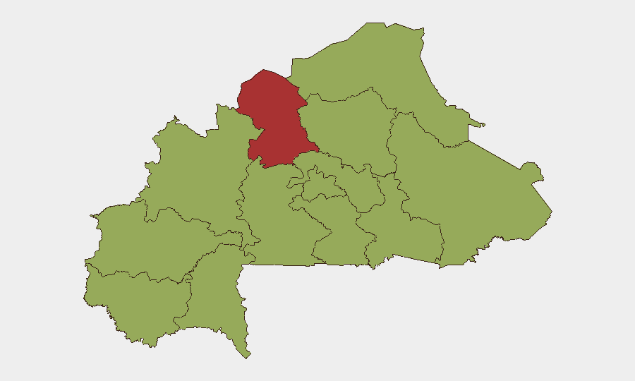
Burkina Faso remains a high-priority security environment (global rank #22) driven by persistent jihadist activity, ethnic tensions, and now acute diplomatic volatility. The military government severed diplomatic relations with France on 26 June, a major political rupture that signals deepening isolation from Western security partners and potential shifts in defense relationships. No major armed clashes or attacks were reliably confirmed in the past 24–48 hours, but the governance tightening and foreign-policy break create elevated political risk for international personnel and operations. The North region accounts for the largest concentration of active threat drivers; Centre region remains secondary but material.
Key Developments
- Ouagadougou, 26 June: Military government formally severed diplomatic relations with France effective immediately, citing "neo-colonial ambitions" and alleged French support for "subversive networks" and "terrorists." Statement delivered via national television and confirmed by Prime Minister's Office communiqué.
- Ouagadougou, 26 June: Government adopted ministerial decree requiring all students seeking higher education abroad to obtain prior authorization from the Ministry of Higher Education, following Council of Ministers meeting. Authorities link measure to control over overseas training; coincides with May suspension of main student union for alleged "glorifying terrorism."
- National, 24–48 hours ending 26 June: No reliably confirmed attack, clash, or infrastructure incidents reported across mainstream and vetted OSINT feeds. Unverified social-media claims of attacks around 22–23 June lack independent corroboration and remain excluded from operational summaries.
- National, 23–26 June: Continuing pressure on journalists and civic actors documented nationwide, including unresolved secret detention cases; no new specific incidents in the 24–48h window but human-rights monitoring advisories remain active.
- Regional context: ECOWAS issued public statement 25 June regarding Burkina Faso; diplomatic isolation appears to be accelerating regional tension.
Highest-Risk Areas
The North region (composite risk 79.8) remains the primary driver of threat activity, reflecting ongoing jihadist-group operations, IED activity, and intercommunal violence. Centre region (52.1) encompasses the capital and administrative apparatus; while lower in absolute threat intensity, it carries disproportionate political-stability implications. The remaining regions cluster at 49.8, indicating a broad but secondary dispersal of risk outside the North–Centre corridor. The diplomatic rupture with France may reduce foreign-military presence and intelligence-sharing in these regions, potentially degrading early-warning capacity for armed groups.
How GeoBit Would Assist
Security teams should deploy AOI Monitoring & Early Warning tools across the North and Centre regions to track armed-group movement, checkpoint activity, and population displacement in real time. Intel Sweep and multi-language OSINT fusion (X/Twitter, Telegram, local news, and radio SIGINT) will capture political messaging, recruitment rhetoric, and human-rights violations faster than daily briefs. Network & Actor Analysis should map changes in French military/intelligence footprint and monitor whether rival powers (Russia, Turkey, Gulf states) increase engagement, signaling shifts in operational environment and threat posture.
7-Day Outlook
The diplomatic rupture with France will likely prompt French military and intelligence personnel withdrawals within days, creating a potential security vacuum in the North that armed groups may seek to exploit. Expect heightened nationalist rhetoric from the military government and possible further restrictions on civil society, foreign media, and international NGO movement. The governance tightening around student travel and civil freedoms may accelerate emigration of skilled personnel and reduce international corporate staffing, particularly among French nationals.
Highest-Risk Areas — Ranked
| # | State / Region | Risk |
|---|---|---|
| 1 | North | 79.8 |
| 2 | Centre | 52.1 |
| 3 | Upper-Basins | 49.8 |
| 4 | Boucle du Mouhoun | 49.8 |
| 5 | Central-West | 49.8 |
| 6 | Central-South | 49.8 |
| 7 | Central-East | 49.8 |
| 8 | Waterfalls | 49.8 |
| 9 | Southwest | 49.8 |
| 10 | Sahel | 49.8 |
| 11 | Central-North | 49.8 |
| 12 | East | 49.8 |
Sources
Previous Daily Briefs
A new Burkina Faso brief is written every day — each with its own risk map and downloadable CSV. Here's the last week; use the calendar to go further back.
📅 Browse every day by calendar →
Highlighted days have a brief. Tap a day for that day's map & analysis, or “csv” for that day's dataset ($5).