Situation Summary
East Timor remains in a stable security posture with no reportable acute incidents or civil unrest in the last 24–48 hours. The country's composite threat score of 3 reflects a historically low-risk environment with no tracked active security events. Baseline vulnerabilities persist in urban centers (particularly Dili) and western border regions, but these reflect structural rather than emergent risks at present.
Key Developments
No discrete security, civil-unrest, conflict, crime, or infrastructure incidents were identified in open-source reporting for 2–3 August 2026 meeting verification standards. Recent media coverage from national outlets (Tatoli, The Dili Weekly, Timor-Leste Government portal) and regional feeds carries no time-stamped reports of acute incidents within the last 24–48 hours. Routine law-enforcement and governance activity (including transnational crime cooperation frameworks and defense agreements) continues but does not constitute emergent risk developments. The absence of reportable incidents aligns with East Timor's broader stability profile over the preceding month. No alerts or early warnings from OSINT feeds or regional news wires indicate deterioration in the near term.
Highest-Risk Areas
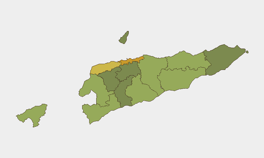
Dili (risk score 72) dominates the sub-national threat ranking, reflecting its status as the capital, primary commercial hub, and highest concentration of personnel and infrastructure. Liquiçá (62) and Baucau (58) follow, with Liquiçá's proximity to volatile border regions and Baucau's role as a regional transit node contributing to elevated scores. Western border municipalities (Cova Lima, Bobonaro, Oecussi-Ambeno) maintain elevated risk profiles linked to historical cross-border movement, informal trade, and limited state administrative capacity. Central and eastern regions (Aileu, Ermera) show substantially lower risk, reflecting lower population density and reduced incident history. Corporate security teams with Dili-based operations should prioritize monitoring of capital-region mobility corridors and port/airport security; those operating in Baucau or border zones should apply heightened situational awareness protocols for supply-chain and personnel movement.
How GeoBit Would Assist
Security teams monitoring East Timor should deploy AOI Monitoring & Early Warning on Dili's central business district, port facilities, and primary transit routes to detect emerging protests, infrastructure disruption, or security incidents in real time. Intel Sweep, OSINT fusion, and multi-language search across national media, social platforms, and regional feeds provide continuous baseline monitoring at lower cost than field presence, with sentiment and temporal analysis flagging anomalies in political or civil-unrest discourse. Routing & Network Analysis can pre-plan personnel evacuation or alternative supply-chain corridors should conditions deteriorate in primary transit zones (Dili–Baucau corridor, western border crossings).
7-Day Outlook
No indicators suggest near-term deterioration in East Timor's security environment over the coming seven days. Political and diplomatic activity remains routine; no protest mobilization, labor action, or ethnic/political tensions are visible in current open-source signals. Monitoring should continue at baseline levels unless regional developments (e.g., maritime incidents, Indonesian border friction) or domestic political announcements alter the current posture.
Highest-Risk Areas — Ranked
| # | State / Region | Risk |
|---|---|---|
| 1 | Dili | 72 |
| 2 | Liquiçá | 62 |
| 3 | Baucau | 58 |
| 4 | Cova Lima | 55 |
| 5 | Bobonaro | 53 |
| 6 | Oecussi-Ambeno | 48 |
| 7 | Manufahi | 45 |
| 8 | Viqueque | 42 |
| 9 | Manatuto | 40 |
| 10 | Ainaro | 38 |
| 11 | Ermera | 36 |
| 12 | Aileu | 32 |
Sources
Previous Daily Briefs
A new East Timor brief is written every day — each with its own risk map and downloadable CSV. Here's the last week; use the calendar to go further back.
📅 Browse every day by calendar →
Highlighted days have a brief. Tap a day for that day's map & analysis, or “csv” for that day's dataset ($5).
Atlas — our AI intelligence desk — emails them this snapshot personally. Nothing else, no list.